Saturday, September 30, 2017

road tripping: day 3

Checking out the Goosenecks 

Our final day of road tripping found us back on the road around 8 a.m.  We made several stops in Capitol Reef: walking into the Goosenecks, to peek 800 feet over the edge at the river below; checking out the orchards and the historic schoolhouse; and gazing at the numerous Fremont petroglyphs carved into the cliffs along Route 24.

The Goosenecks in the morning sun

Desert landscaping

We kept going east on 24, out of the park and through the desolate moonscape of cliffs and rolling pale rock to Hanksville.  There, we headed north for Goblin Valley State Park.  H's parents didn't know anything about Goblin Valley ahead of time and were delighted with all the goblins.  We walked through the rock formations for a bit; under the clear skies it was warm among the goblins but a nice breeze was blowing through off the valley floor.

Parade of petroglyphs

To wrap up our road trip, H and I decided we should finish things off the way we usually finish trips off in that part of the state: with lunch at Ray's Tavern in Green River.  Ray's was decently busy, as it always is whenever we find ourselves there, whether it's a Sunday or a Wednesday, with construction workers, locals, tourists and outfitters.  Burgers, beers and recapping favorite parts of the road trip were on the menu.  It's always a bit of a letdown when a trip ends but we think H's parents had fun, seeing parts of Utah that they've only heard about before.  I know we had fun and are just counting the days until the next road trip.

Goblin Valley

Among the goblins

Wednesday, September 27, 2017

road tripping: day 2

In the morning, H went for a run under a gorgeous pink and orange sunrise before we all had a tailgate breakfast of fruit and bagels, accompanied by pretty good coffee from the motel's breakfast room.  We got ourselves organized and were on the road back to Bryce by 8:15 a.m.  Once at the park, we checked out the awesome views at Sunrise Point and recycled a used propane cylinder (Bryce seems to be the only Utah national park that collects those cylinders for recycling).

The Amphitheater in the morning

We then headed out, stopping at Kodachrome State Park, and then continuing along scenic Route 12 through Henrieville.  H and I had only traveled short pieces of Route 12 before - from Bryce to Kodachrome; and then on the other end from Torrey up to our campsite at Single Tree - so this portion of the road trip was new to us.  Scenic Byway 12 is said to be one of the most gorgeous roads in the country and I can believe it.  We followed the river for a while, past high, pale cliffs, and stopped to check out a Native American granary high in the rock above us.

H's folks

The road passes through the funky little town of Escalante (population around 800, with the Shooting Star RV Resort, where you can rent vintage Airstreams, and a wonderful visitors' center).  After Escalante, we came around a corner and the vistas just opened opened up in front of us.  We could see forever, it seemed, and we could also see our road twisting and turning below us, winding in and out of the colorful rock formations.  We continued down past those rock walls and then up and over the Hogsback - a high and very narrow stretch where there were impressive drop-offs on both sides, and no guardrails - before descending into little Boulder (population: approximately 200).

Road trip!

Ancient granaries

We paused for a snack on the picnic tables in front of the Anasazi State Park Museum, then kept going, up and over Boulder Mountain.  For a while, our surroundings were green and forested, and we passed by our former campground, then it turned back to red desert as we descended to Torrey and Capitol Reef National Park.  Capitol Reef is more of a hikers' park as most of the park is only accessible on foot or rough 4WD roads.  To enable H's folks to see as much as possible, we did the paved part of the scenic drive, stopping at the picnic area under the red cliffs when the road changed to dirt to continue through Capitol Gorge.

Scenic Byway 12

After retracing the route through the desert and then the old Mormon pioneer-planted orchards, we returned to Torrey, checked into our motel and then figured out what to do for dinner.  We checked out a couple places before deciding on Red Cliff Pizza (yes, pizza for two nights in a row) at Red Cliffs Pizza which a work friend had recommended.  As we filled our bellies, the restaurant filled up around us with both tourists and local cowboys.  When we were done, we headed back to the room for an evening in.

Scenic Capitol Reef

Saturday, September 23, 2017

road tripping: day 1

As I mentioned, H's parents came for a visit recently.  Usually when they come, they only stay for three or four days; this time, H convinced them to stay long enough for a road trip.  H's mom had mentioned that she wanted to see Bryce Canyon National Park and we figured that we could put together a quick loop that included Cedar Breaks National Monument and Capitol Reef National Park as well.

The Cedar Break Amphitheater

H and me at Cedar Breaks National Monument

To facilitate scenery viewing and ease of toting people and luggage, we rented a minivan, picking it up at 7:30 Monday morning and heading south on I-15 by 8.  Once we got past Provo, the traffic thinned out and it was smooth sailing all the way to Cedar City.  We drove up the scenic road to Cedar Breaks National Monument, arriving midday.  It was much nicer weather than when H and I had been there last, clear and cool this time up at an altitude of 10,350 feet above sea level.  The monument's amphitheater glowed a soft orange, pink and white under the sun.

H and his folks at Bryce Canyon National Park

We continued down Route 143 to Panguitch, then turned before hitting town (no sense in getting to Panguitch too soon) and going straight up to Bryce Canyon National Park.  It was clear and breezy, warm in the sun but cool in the shade.  For a late September Monday, it seemed pretty busy and as we headed out the scenic drive towards Rainbow Point, we were a little worried about finding parking.

Along the BCNP scenic drive

The crowds weren't really a problem, however, as we were able to stop at nearly every overlook as we worked our way back.  The only places we couldn't get into were Bryce Point and Sunrise Point where there were "PARKING FULL" signs and park rangers turning cars away.  Figuring we'd come back in the morning for Sunrise Point, we opted for beers and snacks at the Fairyland trail head to finish the afternoon.  Fairyland is great: since it is technically outside the park gates, it doesn't get nearly as many people and we had the picnic table all to ourselves.

The Amphitheater at BCNP

Even though H and I had done that scenic drive when we were at Bryce before, it was totally different this time: last time it was raining and cloudy and we couldn't see anything our first day.  This time, there were no clouds at all and the views stretched on forever.

An arch at BCNP

We drove back to Panguitch and checked in at the Adobe Sands Motel.  This is another tiny independent motel, one of about a dozen that line the town's main street.  The Adobe Sands was not fancy, big or particularly modern but the kid checking us in was super-friendly, the rooms were clean and the bed was much more comfortable than it looked.  (And in the morning, we would discover that the showers were very hot.)

Fairyland TH picnic

We had beers outside the room then went in search of dinner.  Dining options in Panguitch are still limited and our first choice, the Cowboy Smokehouse, continues to be closed on Mondays.  So we ended up a few blocks out of town at the C-Stop for "artisan" pizza.  The place was packed but the frazzled (but still very nice) waitress said we could sit at the tables outside if we didn't want to wait.  It was still pretty warm so that's what we did, patting puppies and talking with hippies until our very good pizza arrived.

The whole room, not including bathroom

After dinner it was back to the motel for a couple more beers out front as the stars came out.  Despite our being in town, Panguitch is small enough that there wasn't much light pollution.  We could see the Milky Way glittering above us and it was beautiful.

Awesome motel sign

Thursday, September 21, 2017

placeholder

We just had H's parents in town for a visit and were out and about doing stuff and seeing things.  I'm getting the photos organized now and will have actual posts up soon but in the meantime, here's a taste of what's to come:


Wednesday, September 13, 2017

why yes, i will ride 3+ hours uphill for a beer

Last year around this time, we did a long MTB ride on the rail trail from Echo Reservoir to Park City and back again.  It was on my list to do again this summer: although it isn't a difficult ride from a technical standpoint, the challenge is the distance.  I am not the cyclist H is and never ride much more than twenty miles at a go, so 54.4 miles would be a long day in the saddle.  When we looked back at last year's post, we were reminded that we got to Squatter's over an hour before beer was allowed to be served.  We didn't intend to make that mistake this time and reorganized our schedule accordingly.  We left the house at 7 a.m., driving through Parleys Canyon and continuing east on I-80 past Park City.

We didn't see any of these

We were on the rail trail around 8 a.m. and although it was still cool, it was noticeably warmer than last year.  I had remembered how cold I was before and this time brought a pair of hand-warmers that I stuffed into my long-fingered biking gloves.  As we pedaled past the reservoir, my fingertips still got cold but it never got so bad that I had to stop to warm them up.  Things were quiet at that hour, a few fishermen on the reservoir; people just stirring in the campgrounds.  We got past the end of the reservoir and rode through farms, where the various critters either ignored us entirely when we called to them or looked at us with mild curiosity before getting back to grazing.

We did see these: sandhill cranes

Wildlife spotted:  hawks, eagles, pelicans, cottontail rabbits, goats, sheep, pigs, cows, horses, geese, alpacas, dogs, cats, sandhill cranes, squirrels, lots of songbirds, a frog and a cowboy who tipped his hat to us when we pulled off the rail trail to let him ride by as his horse eyed us suspiciously.

The low clouds stuck to the foothills for a while and it wasn't until we got to Wanship to start the climb to Park City.  "Climb" is a relative term: we were definitely going up but it was never steep since the rail trail used to be the Union Pacific railroad and trains can't do steep.  It was here that we started to see a few people - a trail runner and two or three cyclists, all heading down/east - but the trail was never very busy.

Hooray for beer!

We got to Squatter's a little after 11 a.m., making the inbound trip in only 3 hours and 15 minutes.  This time we didn't have to wait for beers so we split a pitcher of Full Suspension with our food (chips and salsa, veggie burger, fry bread and raspberry sauce).  We had stopped a couple of times en route for snacks as an anti-bonk plan but we were still hungry and the food went down fast.  As Squatter's filled up around us with brunchers, we finished up, reapplying sunscreen and hopping back on our MTBs by 12:30 p.m.

As before, the first part of the return trip flew by.  Since we were going at a steady (but not fast) pace, my legs were holding up fine; our backs and "sit-bones" were starting to get uncomfortable, however, because this was a long time in the saddle, even for H.  And I continued my recent trend of being kind of dumb: I was not drinking nearly enough water and got a bit dehydrated, which resulted in pretty painful cramps (no lasting damage done and completely remedied by the application of GatorAde on the ride home).

Done! Where's the beer?

By the time we got back to the truck, at about 2:45 p.m., I was ready to be done cycling and open a celebratory beer.  Because I feel like completing this ride is reason to celebrate.  It's not technical but it's long, and it's really fun to ride along with so much to look at.  We really like riding it and I suspect that this won't be the last time we do it.  And next time I'll drink more water.

This looks much steeper than it is - keep in mind it's
stretched out over 54+ miles, with not even 1,500 of elevation


Friday, September 8, 2017

american fork twin peaks: 2, h&a: 0

I really wanted to hike on Monday but hadn't managed to come up with any ideas other than an attempt on American Fork Twin Peaks from the other side.  Knowing that I had a bit of a blister from trying to break in my new boots, I didn't think an attempt from Red Pine/White Pine was advisable - those hikes are 7-10 miles round trip even without climbing up to the summits.  So our best bet was going to be back at Snowbird, via Gad Valley.  We've sure been up at Snowbird for hiking a lot lately!  We got up there before they started charging for Oktoberfest parking and were on the trail around 8:30 a.m.  I had moleskin on my blister and slightly thicker socks and hoped for the best.

View of Superior from under Gad 2

The first part of the hike was the same as last time: from Snowbird center, up the Dick Bass Highway to the Gad Valley trail.  Before we reached the mid-Gad lodge, however, the trail split and we bore right/west on the Gad 2 trail, which was really a rough dirt road leading up to the Gad 2 lift.  It was very pretty, with streams and nice trees and with all the greenery, not to mention being less traveled than the Gad Valley trail, we were sure we would see moose, or at least deer.  We didn't.  We climbed steadily and gained a good amount of elevation but it never seemed like we were working very hard, which was a nice change from that super-steep Gad Valley trail.

Across the boulders 

And up the slope to the ridge

We paused at the top of the Gad 2 lift to reconnoiter because this was where the trail/road ended.  From what we had researched, we needed to scramble up the bowl to the ridge - which formed the boundary between Snowbird and Red Pine/White Pine - and then follow the ridge to the summits.  We waded through a small late summer flower meadow before working our way over a boulder field.  I love that sort of rock-hopping and moved pretty quickly, despite starting to favor my right foot; H moved steadily but more slowly, concerned about shifting rocks and twisting knees.  At the upper edge of the boulder field, the rocks grew smaller in size, a talus slope with lots of grass that swooped steeply up to the ridge line.  Picking our footing carefully, and being on hands and feet half the time due to the grade, we made our way up the slope as pikas scolded us.

White Pine Lake from the ridge

The views were fantastic from the ridge, where we were seeing familiar scenery from a brand new vantage point.  A faint usage trail faded in and out along the ridge for us to follow and we could see how much more we had to do as the ridge to the summits curved overhead.  The ridge seemed to be alternately easy walking and scrambling with route-finding where you didn't want to lose your footing, so we took our time - and I found myself going slower and slower as the pain in my heel grew sharper and sharper.

That's the way up the ridge

We had gotten to a rocky knob that we would have to sortie around when I had to throw in the towel.  I took off my boot to check my right heel and was a bit dismayed to find that the generic moleskin had slid away and that the blister I had been trying to protect had ripped off.  We'd already come four miles, with another mile or so to the summit; I knew I was going to struggle with the return trip from where we were, much less adding another couple of miles to our round trip.  I replaced the moleskin and added some duct tape as reinforcement, apologizing to H for wussing out.  I couldn't believe that this was our second unsuccessful attempt at the same mountain.  Then we headed down.

H on the ridge 

Instead of retracing our steps exactly, we followed the ridge down a little further and picked up another faint trail, complete with some loose scree switchbacks.  It was slow going - made even slower when H got a work phone call that he had to take for twenty minutes - but we safely made our way back down the slope and across the boulder field.  We paused for snacks and for me to add more duct tape to my heel, and then it was just a plod out and down the road.  On the plus side, we did finally see some moose, just as we started down from the top of the lift.  A cow and calf were browsing in some small trees, and a young bull was feeding just across the meadow from them.  They were completely unconcerned by us, which is as it should be.

Duct tape fixes everything, right?

The moose is loose

Despite my ministrations, my heel hurt a lot.  I started walking with a funny foot position to try to relieve the pressure, which started a sharp pain flaring up my shin.  By the time we got back to the car, I was in a fair amount of pain - which was immediately relieved when I took my boot off, revealing a bloody mess.  H didn't even have to scold me for attempting an 8+ mile hike in brand new boots with an existing blister - I had been scolding myself for being a dumbass the whole way down the mountain.  A cold beer went a long way towards making things better, however.  And the funny thing is, my left boot performed great, leaving me without even a hot spot on that foot.

First sighting of golden aspen leaves - fall is here

Clearly, I will need to work on breaking those boots in, once my foot heals enough that I can wear shoes with closed heels.  Until then, I will be anticipating our next try for American Fork Twin Peaks because despite all my whingeing about my heel, this was a very fun hike.  Both H and I are sure we can do it.  It was not particularly taxing, at least the 8+ round trip miles we did.  From what we could tell, the ridge line is not nearly as vertiginous as the approach from Hidden Peak, and with new (broken in) boots with good treads, I'm less nervous about scree.  The third time will be the charm.

Post-hike carnage

Hike stats: 8.10 miles; 3:15 hours moving/2.5 m.p.h. moving average; 4:13 total time/1.5 m.p.h. average speed (lots of stoppage); 2,800 feet of elevation.

Tuesday, September 5, 2017

backwards

After not having enough tread to finish American Fork Twin Peaks the weekend before, I went right to REI and got myself a new pair of hiking boots.  I've been wearing Merrell light hikers but went with Keens this time because the toe box was so much wider.  The Keens are higher (above my ankles) and quite a bit stiffer (more leather) so I knew I'd need to break them in a bit.  We didn't make plans for Saturday - other than chores, ugh - so I took my new boots on a 3.5 mile walk right from the house.  The left foot was perfect but my right heel rubbed a bit, leaving me with a dime-sized blister. Knowing I'd need to coddle that blister to keep from ripping it right off, I suggested that we MTB on Sunday.  A patch of moleskin later, we were in Park City for our Round Valley usual ride around 9 a.m. Sunday morning.  I had been musing about trying some different trails but H up and suggested that we do our regular route but BACKWARDS.  (Not actually riding backwards.  Riding the circuit in reverse direction.  Just to be clear.)

Coming UP the Sagebrush Switchbacks

It was so weird.  I know those trails so well but they seemed completely new.  First, we started out immediately on single-track which meant that I didn't have any time to get the wobbles out on the double-track per usual.  Second, I had to focus extra hard because my brain would recognize the stretch of trail we were on and would try to remind me what was coming around the corner, but in reverse - very disconcerting.

And third, that circuit is much easier backwards than our regular way: we rode down the Staircase; the climb up the Sagebrush Switchbacks is easy; we rode down the Sweet Sixteen; we [walked our MTBs] down Hammerhead; and the one stretch I was concerned about - the rocky descent to the bottom of My Nemesis - was fine and I rode all of it.  I wasn't crazy about going down the Sweet Sixteen because downhill switchbacks are not my strength - clearly I prefer climbing to descending.  But the very last stretch was a treat, cruising back down to Quinn's Trailhead on that double-track.  I think I prefer our usual route but I think it is really good to do it the other way, just to shake up the muscle memory.  Maybe next time we'll incorporate some new trails!

Friday, September 1, 2017

back to the 'bird

After our Round Valley ride on Saturday, we drove home, got cleaned up, threw some gear in a bag and headed back up to Snowbird.  We had booked a room at the Inn at Snowbird for one night, as a little mini-getaway.  Although we got up there early (around 1 p.m.), our room was ready for us: approximately 430 square feet with a Murphy bed, sitting area, kitchenette and good-sized bathroom, as well as a private balcony.  Since it was on the north side of the property, we had a view of the canyon road instead of the ski mountain, but even that "reduced" view gave us blue skies and cliffs far overhead.  The Inn does not have air-conditioning but since it was a private balcony, we just opened the slider wide and left it that way.

That's still a darn good view

Snowbird has Oktoberfest going on now (mid-August through mid-October, to take advantage of the lovely late summer/early fall weather).  We had remembered to bring our mugs this time so we spent the afternoon sipping overpriced beers - H actually got one for free when a drunk guy bought one for him after they bonded in line, talking about visiting the Guinness brewery and Jameson distillery in Dublin - listening to oompah music and people-watching.  And let me just say that there is world-class people-watching at Oktoberfest.

That's our little blue Subaru way down there

Water pouring out of the mountain through this crack

We hadn't had a lot to eat all day so after much traipsing through the Cliff Lodge, we finally found El Chanate (seriously, a couple more signs would be helpful).  We got seats on the deck, with a view of the tram going up and down, and munched on good chips and salsa while perusing the menu.  We each had margaritas, which were strong enough but not that flavorful; H had a veggie burrito; and I had the portobello fajitas.  The service was good and the food was fine although you can get much better Mexican down in the valley.  After dinner, we stopped by the Inn's swimming pool, floating around until it was invaded by other guests, and then called it a night.

That's where we're heading, knife edge (partial) on the left

Frickin' steep Gad Valley trail (I'm the dot in the middle)

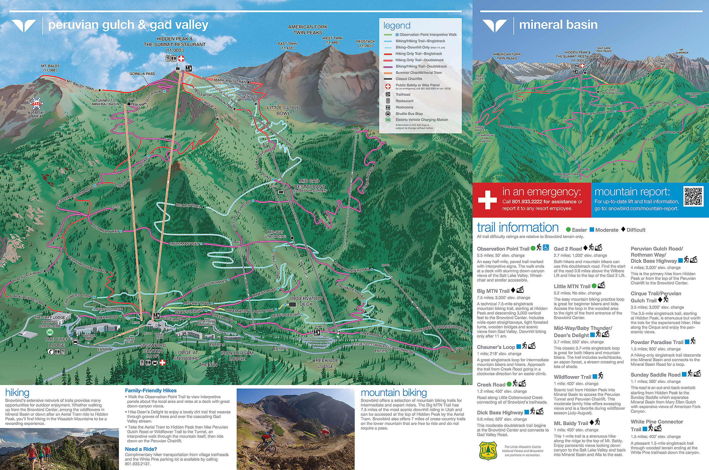
After breakfast at the Forklift, we checked out, moved the car to the main parking lot and started our hike.  The plan was to go up the front face of the resort, then attempt bagging the summits of American Fork Twin Peaks.  We saw a couple of other people on the trails as we headed out on Dick Bass Highway, but once we crossed under the Wilbere Lift folks got scarce.  We turned onto the Gad Valley Trail, which is actually an access road, which just got steeper and looser the further up we went.  It was a slog, to be honest.  When we had hiked up Snowbird last October, we were on the Big Mountain trail, which is downhill MTB only in the summertime, and that was much more enjoyable.  Once we reached the upper bowl of Gad Valley, we got on the Regulator Johnson trail for the final push.

On the Regulator Johnson trail

We didn't linger at the top of Hidden Peak, instead going down the saddle past the top of the Little Cloud lift.  This is where you can pick up the unofficial "use" trail to American Fork Twin Peaks.  The research we did varied wildly, with the route being described as intermediate to not-for-the-faint-of-heart as you have to cross a narrow knife edge that drops off precipitously, do some scrambling and then make your way up a steep, exposed, loose-rock trail, with some light route-finding along the way.  Just before the knife edge began, we were able to stash our hiking poles under a tree, knowing we'd want both hands free.

A boulder portion of the knife edge

I'm just going to cut to the chase: we didn't make it.  My boots, which I've had since 2013, have no tread left.  They do okay on slick rock or dry boulders but are terrible on gravel.  Much of the first portion of the knife edge was boulder or slab but it also had a fair amount of sand and gravel on top of the rock and that made me very, very nervous.  For his part, H isn't a huge fan of heights and the drop-offs falling straight down on either side of the knife edge were intimidating.  The "trail" faded in and out but that wasn't a huge deal since the ridge was so very narrow that there wasn't much choice as to where we could even walk.  We got about halfway across before we decide to turn around, our unease overtaking our desire for the summit. (Here's a good description of the hike, although I do wish she'd talked a little about the descent with all that loose rock.)  We were a little disappointed that we hadn't finished what we'd set out to do - but we're already collecting alternate routes (from the Gad 2 chair here and here and from White Pine Lake here) and are determined to get those summits someday.  After I buy new boots.

That's the knife edge stretching across to the first Twin

Hike stats: 6.14 miles; 3 hours 11 minutes (2:04 moving); 3,000 feet of elevation