Since the end of July (I can't believe it's already the end of July!) means the Wasatch Wildflower Festival - and more on that later - we again switched up our routine to MTB on Saturday. We planned ahead and got everything ready Friday night so that we could just roll out of bed and be on our way at 7 a.m. Again, we parked at the in-town rail trail lot to allow me some extra miles on the bike, and the initial downhill brought goosebumps to my arms since the air was nice and cool. Five hot air balloons floated overhead and it was another gorgeous day.
Up, up and away
The first thing we noticed was that there were a lot more people out walking their dogs than there had been the prior Saturday. We had been surprised by the relative lack of people on the trails then; now we realized that it was because of the long, Utah-only holiday weekend and folks that would regularly be out on the Round Valley trails had likely gone out of town. Still, everyone was very cordial and the earlier hour meant that we were ahead of most of the other MTBers.
Other than having to put my foot down on the Sweet Sixteen climb when a downhilling dude didn't yield (uphill traffic has the right-of-way, dude), I rode pretty well. I seem to be gaining some confidence back and am slightly less squirrelly in my bike handling. Slightly. I've decided that my new favorite part of the whole ride is that Staircase climb: because it isn't rocky, I can climb it even though it is still a challenge and once at the top, it's basically all downhill from there.
Upright, smiling
After we got home, H went for a road ride and cut the lawn while I did laundry and made up stuff for dinner. We headed up to Snowbird for a fantastic show, the Sweet Lillies, then returned home and crashed. Summer is almost over - got to squeeze every bit out that we can.
Monday was a state holiday for Utah: Pioneer Day, celebrating the arrival of the Mormon settlers in the Salt Lake valley. Neither H nor I are much for parades so we thought we'd come up with something else to do. He really wanted to do a bike ride early before it got too hot, while I really wanted to hike and knew that it would have to be early to get ahead of the holiday crowds. So we went our separate ways. Mine took me up Millcreek Canyon to do the Lambs Canyon up-and-down-and-up-again-and-down-again.
So green!
We did this exact hike just over a year ago: that post has the hike stats and hike profile; I did it in almost the exact same time this go-around. When I got to the trailhead (shared with Mt. Aire), there were already a bunch of cars but I had a feeling that those hikers were all on the Mt. Aire trail. I was right as I saw very few people. On my way up the Millcreek side, I saw two high school trail runners; on my way down the Lambs Canyon side, I saw two hikers heading up; going back up Lambs Canyon, I passed one trail runner who was walking up and then those two hikers, plus another trail runner, coming back down; and going down the Millcreek side I saw two hikers on their way up, and a trail runner caught me right at the very end. That's only eight people on a holiday hike in the Wasatch - amazing.
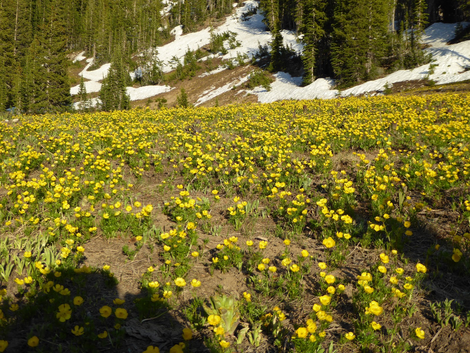
The flowers are pretty nice at the top of the pass
There are good reasons for this trail being less well-traveled than many others in the area. There aren't really any views since the high point is on a tree-covered pass so you don't get the satisfaction of a summit. It's a fairly long trail if you do what I (and all the trail runners) did: eight miles for front to back to front. More importantly, the Millcreek side is really quite steep. The footing for the whole thing is pretty good, though, almost all packed dirt with just a couple of brief rocky sections on the Millcreek side. I can see why trail runners like it, especially the Lambs Canyon side (although that side tends to be very humid).
I kept a consistent pace, finishing the whole thing in about three hours, including just a little bit of stoppage time. Things were picking up along the Millcreek Canyon road as I got out of my boots, pounded a beer and snarfed down a sandwich: road cyclists working their way up, MTBers cruising down, hikers and dog walkers hitting the trails and holiday-going picnickers setting up for their Pioneer Day lunch al fresco. I was glad to be getting away from the hubub, but equally glad that I'd gotten the chance to have a bonus day to get some dirt under my boots.
Here's the thing: I really, really dislike the current [catchphrase/saying/???], "Sunday Funday." It makes me twitch, like the word "moist" or fingernails on a chalkboard. And yet this past Sunday was so much fun! Here's what went down.
Looking waaaay down from the Needles trail
On summer Sundays, Snowbasin has "Blues, Brews & BBQ" which is pretty much what it sounds like - live music, beer and cooking out on the lawn at the base area. We hadn't gone up for any yet because Snowbasin is a bit of a drive from our house but this time we didn't want to miss it since Andy Frasco & the U.N. were playing. We'd seen them a few years ago at Snowbird and knew it would be a party; we thought we'd go up a little early and get a hike in first.
There really are a bunch of switchbacks in there
We got up to the resort and on the trail around 1:00 p.m. The crowd was already gathering on the lawn for the opening acts but we had to put some miles on our legs before joining them. The hike was the same one we did back in September 2015: about six miles of uphill and then a welcome ride down on the tram. It seemed pretty hot as we started out, grinding our way up the Needles trail. The ambient temperature was mid- to high 80s but the sun was strong and it didn't take long to get sweated up.
The scenery is pretty nice up at Snowbasin
The Needles trail (MTB/hiking) parallels an access road for a ways so we stayed on the road. It was exposed (actually, pretty much the whole hike is exposed) but by staying off the singletrack, we were able to avoid some MTBers. When the road faded away, Needles continued on (and up) as dusty singletrack, quite steep in some sections and also fairly rocky underfoot. I always forget how rocky the Snowbasin trails are until I'm back on them. We started to encounter more MTBers at this point: the long Needles trail is popular with folks who have taken the tram up with their bikes. Since we were walking uphill and the bikers were all coming downhill, we were able to see them coming and step off the trail for them with no surprises.
View to the east down the cirque
We came off the Needles trail for a number of switchbacks on the Becker and Diamond trails, which gained us quite a bit of elevation before we rejoined the Needles trail for the final push to the top. When we got to the lodge, we ducked inside to get more water and then did the quick (twelve minutes) push to the top of the cirque for 360-degree views. We had seen very few people on our hike up so sharing the cirque trail with people - clean people, some wearing sundresses and sandals, who had ridden up on the tram - was a bit of a shock.
H, atop the ridge
After that, the only thing left to do was walk back down to the Needles lodge and hop on the tram for a quick ride down to the base. The party was in full swing but we went straight to the car to change out of our very sweaty hiking duds and pound sandwiches and a couple of beers. It was a good thing we did - because you could go broke at this shindig buying beer! Lots of people had prepurchased giant steins which apparently gave you a bit of a break on the price of the beers. We didn't have those steins, however, and were shocked to learn that a tiny cup of IPA was $6.00! You could get large cans of crap beer (PBR, Budweiser, etc.) for a mere $7.00 too. I didn't even bother to check out what the food prices were but I can't imagine they were any more reasonable.
Xena keeps H's foot warm
One fantastic thing about Snowbasin is that dogs are allowed since it isn't a watershed. And there were dogs everywhere! Mutts, chihuahuas, golden retrievers, labs, standard poodles, basset hounds, beagles, a massive Great Dane, Rhodesian ridgebacks, Boston terriers ... it was wonderful to be around - and get to pat - all these good dogs. We struck up a conversation with a guy because of his beautiful young German shepherd; he and H ended up talking for quite some time about skiing, mostly.
Terrible picture of the massive crowd - there were tons of people there
The show itself was fantastic and so much fun, especially once Andy Frasco and his band came up on stage. Frasco is a talented showman who is skilled at working the crowd, plus he is very generous with his musicians and kept inviting guys from the prior acts to join them on stage. At one point, there were over sixteen musicians up there, jamming away: drummers, pianists, three guitarists, a bassist, two trumpeters, two saxophone players. They all just looked like they were having a great time too, as Andy Frasco kept crowd-surfing and passing beers around. After playing for nearly three hours, they closed with the Beastie Boys' "(You Gotta) Fight for Your Right (to Party)" with a crowd of kids on stage and the whole crowd shouting every lyric along with the band. So fun. We will make a point of seeing them again if they come back next summer.
The map of the hike can be found at this earlier post. It took us about three hours and was right around six miles, plus the two on the tram ride down. (That hike would be much less pleasant if you were to have to walk downhill too.) Wicked fun day.
Since we had specific plans for hiking on Sunday, we did our MTBing on Saturday instead. We don't often go to Park City on Saturdays and so don't have a good sense about how crowded things might be. That, coupled with the fact that it was going to be around 100 F in the valleys later, encouraged us to get an earlier start than usual: leaving the house in time to get on the trails by 8 a.m. We went back to our former, usual parking lot - in-town, along the bike path - in order to get me on the bike for longer. Then, with five hot-air balloons silently floating overhead, we started rolling.
The bike path adds another 2.7 miles or so (each way) to our regular ride: downhill for the outbound, and a long slog of an uphill on the return. At that early hour, there weren't many other people out there with us - a couple of runners and one gentleman who was encouraging a snake, that had curled up on the path to soak in the sun, to move out of the way so it didn't get squished. The parking lot at Quinn's Trailhead was pretty busy but that was because of a youth baseball tournament; once out on the dirt, the population got pretty sparse. We saw a couple of desert cottontails and lots of songbirds; I did my best to ignore the ominous circling of buzzards overhead.
Sure doesn't look like it rained yesterday
The earlier morning temperatures were quite pleasant. We got hot and sweaty on the uphills (it has been a little humid lately, being monsoon season and all) but the flats and downhills were lovely. A big storm had moved through on Friday - the lightning for our morning commute in SLC had been impressive - and apparently Park City had gotten a fair amount of rain in a very short time as the system came through. Several places on the jeep roads were washed out; the hardpack singletrack had a lot of loose rock on it; and there were one or two damp spots. The trails were in good shape otherwise, proof that it's been so hot as to dry things up quickly.
I am still squirrelly with loose rock (and sand, I hate sand) but I had a better day. My legs weren't tired, for one, so I climbed pretty well, except for one spin-out on the Sweet Sixteen where I had to put my foot down. We didn't encounter anybody on either the uphill OR the downhill of Rambler - and neither of us can remember a time when that happened. And I forwent the paved path for the stretch back to Quinn's Trailhead, staying on the dirt and climbing the Staircase really well. After that, there was nothing but the long bike path return to the truck and since there wasn't a headwind for once, I was able to cruise that quickly. I even passed some people!
The best part was that since I didn't overdo it, we went up to Snowbird that evening to see Eilen Jewell for the Snowbird Cool Air Concert Series. (H, who did a road ride in the heat after we got home, may have taken a short nap beforehand.)
It is entirely possible that I overdid it on our Brighton ridge run hike. By Saturday early evening, my quads and calves were tightening up, due to the steep sections that I was under-fit for. And I ended up having to take a nap - due to the heat and extra mileage - which meant we skipped the Snowbird Cool Air Concert. By the time Sunday morning rolled around, my quads were very sore and I was avoiding going down any stairs at all cost.
But MTBing seemed like something we should do, to shake off the cobwebs and loosen things up. We managed to get over to Round Valley and on the trails by 9 a.m. There were enough cars in the parking lot that I ended up being surprised when we didn't see more than a couple of dog-walkers on the front half of our ride. We did have to stop for a few minutes to encourage a tiny baby desert cottontail off the trail and into the sagebrush; while H shooed him away, I drank a lot of water and was grateful to rest my legs.
Grimace? Smile? Hard to say exactly
I have not had enough time on the MTB this summer to get my groove back entirely, continuing to be skittish on rocky downhills. I'm working on it and H and I have decided to go back to parking at the in-town lot to give me another four-ish miles on the bike. This day, I did manage to ride a couple of sections pretty well and surprised myself by riding all but two of the Sweet Sixteen switchbacks, those two being the ones I have never ridden. I did spew an impressive string of obscenities while wrestling my MTB up one rocky switchback - but I rode it without putting my foot down, and if high volume swearing is what it takes, then that's what I'll do.
By the time we'd gotten to the far side, however, my legs were toast. H took the newer portion of our dirt trail back while I cruised the paved bike path. He beat me back to the truck although only by 30 seconds or so - he'd clearly been held up by other trail users because I was s l o w. Moral of the story: do your MTBing the day before you do a big hike or suffer the consequences. (Said suffering was alleviated somewhat by judicious application of G&Ts at home Sunday evening.)
Three years ago, we did a great hike up at Brighton, running around the ridge and picking off six peaks all above 10,000 feet. Last year, we climbed Clayton Peak (a/k/a Mt. Majestic). This year, we hadn't been hiking all that much and I was really jonesing for a decent hike. I thought we could link the two together and really make a good walk out of the so-called Brighton Ridge Run.
Unnamed peak; hiker name: H
We were on the trail at 7 a.m., enjoying the cool air and the almost-but-not-quite-at-peak wildflowers on the lower ski runs under the Majestic and Crest Express lifts. We encountered just a couple people before the Dog Lake turn-off and then no one (other than a fair number of unwelcome but slow-moving mosquitoes) as we made our way up. That trail through Brighton's bowls is just wonderful. It climbs steadily but is smooth and gentle underfoot, hard-packed dirt and pine needles - super-cushy. The last bit to the summit is steep with small boulders to scramble; cross-sounding pikas scolded us as we made our way up. Then it was summit #1, Clayton Peak, at 10,750 feet above sea level.
Lakes Mary and Martha from Pioneer Peak
There was no time for lingering, however, because this summit had taken us longer than I thought it would (failure to adequately research falls on me). We also weren't sure how to get to our next summit and had to descend much further than I had hoped before finding a dirt access road which would take us up. This "ridge run" does have a trail but it is faint and fades in and out; a recurring theme for the hike would be losing and re-finding the path. We made our way up through the wildflowers to the ridge behind the top of the Crest Express lift and started around.
Catherine's Pass/Lake Catherine and Tuscarora
That first summit is apparently unnamed (elevation 10,315 ft.) and the trail is barely there either. It's easy to know where you're going on a ridge, however, so we picked our way through the boulders until we found the trail again. There is a fair amount of up and down on this hike, as we descended to the low point and then scrambled up to Pioneer Peak (10,447 ft.). From here, on our left a gorgeous green drainage fell away towards the Heber Valley, and to our right, the Brighton lakes were as full as we've ever seen them, compliments of all the wonderful snow we got this past winter.
Last summit: Mt. Wolverine
From Pioneer Peak to the popular Sunset Peak is probably the sketchiest part of the ridge run. We lost (and found) the trail several times; the footing is extremely sandy and loose; and the ground falls away very steeply, so that whole section is absolutely a "no-fall" zone. It is also a no-other-hikers zone, which is always a treat in the increasingly busy Wasatch.
Wolverine Cirque
There were, however, scads of people atop Sunset Peak 10,648 ft.), as we knew they would be. Lots of hikers will nab that summit as it is an easy extension from Catherine's Pass, whether you've come up from the Alta side or the Brighton side. We left the crowds behind us as quickly as we could, pausing for snacks at Catherine's Pass (where we grievously disappointed the resident chipmunk who had been hoping for dropped goodies) before continuing on. Again, there was a bit of route-finding as the trail faded in and out, but we eventually found ourselves at the summit of Mt. Tuscarora (10,654 ft.), a popular winter summit for backcountry skiers. We had to cross a bit of snow on our way down and back up to Mt. Wolverine (the high point at 10,795 ft.), and then the footing was a bit precarious in spots - narrow, rocky, loose - as we skirted Wolverine Cirque. We even encountered a skier, resting a bit before his second run down the cirque. When asked how it was, he said, "It's a little wavy. But it's good for July," and then grinned at us. Wish we'd gotten to see him ski.
I love this map
We continued around the ridge, picked our way down the boulder field to Twin Lakes Pass. Here, two things were evident: the wildflowers are truly on the verge of peak gorgeousness; and there is so much water in the reservoir that Twin Lakes is just one lake right now. It's great to see. From there, it was basically a long slog out via the ski resort's access roads. It was hot and the gravel footing is looser than I like since my hiking boots tend to slip on the loose stuff. But cold beer and sandwiches were waiting for us at the car and that's good motivation.
Pretty sexy profile there
When the stats were pulled together, we ended up doing 10.64 miles with 4,100 feet of climbing (4:37 hiking and 1:19 stoppage time meant about six hours on the trail all told). That was a longer hike than I had envisioned [see above re poor research skills] but it is such a beautiful hike, and manages to avoid the teeming hordes even located where it is. Totally worth it, every time.
The day of the Crusher in the Tushar itself, all the cyclists in town were up and about early, milling around the staging area before 7:30 a.m. All shapes and sizes of riders were in attendance but it was clear that most of them were riding gravel bikes, although we did note a few more MTBs and hydration-pack wearers than we originally expected. H had waffled about wearing his hydration pack but the ability to carry more water (and tools/tubes) outweighed the weight of the pack.
Pre-race, clean and smiling
After announcements, the start was at 8 a.m., with this start order: pro men; all women (and there were more women than I thought there would be); 45-49 men; 60+ men; 40-44 men; single speed/tandem riders; 50-59 men; 29 and under men; 30-34 men; and last, 35-39 men. H looked very focused as he rode past and I spied our motel neighbor Dan in there too. It was still cool as it neared the start but the day would get much, much hotter.
When the final group left, the PA system played the Benny Hill theme and the William Tell Overture to see them off (which I thought hilarious). I walked to El Bambi for breakfast, sitting at the counter and eavesdropping on locals who were talking about the bike race: "Why would anyone want to do that?!?" I stopped by the room for a little while and then, around 11:30 a.m., drove to the finish line.
H's group starts
The Crusher in the Tushar has been described as "apocalyptic" and "a suffer-fest." Two-time Crusher winnerLevi Leipheimer ranks it up there with the Leadville 100 and the best (worst) climbing days in the Tour de France. Simply put, the 69+ mile pavement/gravel race is just brutal. Here's the course profile:
The first ten or so miles are not so bad, on pavement, climbing gently out of Beaver. Then first dirt starts, climbing aggressively and topping out at over 10,000 feet. (Elevation in town: 5,902 feet.) Next is a very steep, washboarded, switchback-filled, loose descent, losing nearly 4,000 feet of elevation. The pavement kicks back in at mile 31 and continues downhill to Junction, then mostly flat to Circleville.
Lonely road, final stretch (that's not H)
After that respite, the route gets dirty again at Doc Springs Road - which has been called the Sarlaac Pit due to its hellish steeps and loose sand and gravel. The grind continues up the Col d' Crush (most steep, more sand, more loose gravel), topping out at the KOM/QOM around 9,400 feet.
There's a bit of flat as the road goes by Puffer Lake and then it's back on the pavement for the final four miles to the finish at Eagle Point. The TOP of Eagle Point, mind you, with a finishing elevation just under 10,500 feet above sea level. There's really no way to explain just how difficult this route is. The dirt sections, although not technical singletrack, were loose gravel and sand, rarely nicely hard-packed dirt, with switchbacks, swooping curves and ruts. The grades ranged from the gentle-but-constant 2%, on the initial stretch up the canyon from Beaver, to a brutal 14% on the Col d' Crush. The temperature swing was mind-boggling as well, from the hot, dry, exposed 100 F sections down in the valley, to the cold, rainy 40s up in the mountains. The Crusher is as much a mental challenge as it is a physical one but boy, the physical bit is no joke.
When the weather rolled in at the top
H had some goals for this ride. The first one, the one he was most anxious about, was making the cutoff: if riders hadn't gotten to the second aid station (approx. mile 25.5) by 11:00 a.m., they would be yanked from the race and sent straight to the finish. Do not pass Go, do not collect $200. If he made it past the cutoff, he figured he could - at worst - do the ride in 9 hours with a 5:00 p.m. arrival. If he really pushed it, he thought his best possible time might be 7 hours 45 minutes. The plan was for him to text me at various intervals to let me know where he was along the route although I was skeptical that there would be enough cell signal to get through. He did send me a bunch of texts (15 miles to go at 12:54 p.m.; passing the KOM at 1:26 p.m., etc.) but I only got the first - and most important - one: he made it past the cutoff with thirty minutes to spare. For the record, I had always been sure that he would make the cutoff.
The Big Flat (cyclingtips.com)
Photo: Catherine Fegan-Kim.
Without any way of knowing where he was after that point, I didn't really know what to do with myself up at the finish line. The organizers had a great set up with tents and beer and food and volunteers and bathrooms; the ski lodge was open too. I had brought a book with me, thinking I could find a spot to sit overlooking the finish and keep one eye on the road while I read. Spectator parking was at the resort's lower lodge, with shuttle buses running back and forth on the 1+ mile between. I opted to walk and when I got up there, it was gorgeous, sunny and very pleasant. Then the clouds started building and the wind started picking up. It got dark and cold and started to sprinkle. (I had not bothered to bring a raincoat because it hasn't rained in about two months.) We spectators managed to ignore this until the organizers announced that there was lightning within one mile of our location. They shooed us all into the ski lodge while keeping a skeleton crew of volunteers outside to help the riders as they came in. There was lots of thunder and wind and it just poured rain for quite some time, the temperature plummeting. Unfortunately, I had left my additional layers in the truck since my backpack was full of dry clothes for H after he finished - they weren't doing me much good down there.
Descent to Junction (cyclingtips.com)
Photo: Catherine Fegan-Kim.
The storm finally/mostly blew through and we spectators moved back out to watch the riders struggling and/or charging up the final pitch. Where it had been around 100 F in the valley, it was now in the low 40s - more pleasant for the hard-working riders, less so for the chilled watchers. It was still sprinkling off and on so I found a place below the finish line, on the side of the road under some trees where I could see the riders from a distance as they approached. This turned out to be a great spot until a DNR truck drove up and parked right at the bend in the road. Now my view of the coming cyclists was blocked until they were right upon us.
ALMOST FINISHED
A little bit before 3:00 p.m., just when I was thinking of leaving my spot to go find a snack, I peeked around the truck. OMIGOSH! THERE'S H! HE'S ALREADY HERE! Pedaling steadily, face in a breathing and/or grimacing rictus, two hours early. I grabbed the camera and ran (sort of) up to the finish, pack bouncing, to get a photo of him as he came in. He looked so strong. As soon as he crossed the finish line - with a time of 6:56.03!!!! - volunteers came up, wrapping him in a space blanket against the chill and putting his bike in a rack for him. He sat in the riders' tent for a while, drinking a Coke and trying to wrap his head around the fact that he didn't have to pedal anymore. Some of the riders were animated, commiserating with each other about the hellacious ride they'd just finished; others just sat there in a daze.
Finished! Here comes the space blanket
Before H could get chilled, we went to the beer tent (free Epic cans for riders!) and went into the warm lodge. With some sugar, caffeine and beer in his system, H bounced back quickly, telling me highlights of the ride while he changed into dry clothes. He was pretty hungry - he can have a difficult time with nutrition on long rides because his stomach can get upset - so we went to the food truck (free veggies and rice and protein for riders!) and he wolfed his portion down. The organizers were getting the finishers' list up quickly so we kept scanning it for our new friend Dan. His name wasn't on there though, and by the time the very last rider came in, just a couple minutes under nine hours, we knew that Dan must have bailed out. We caught the shuttle bus down to the lower lodge and stopped in at the bar/grill for a beer. The Renegade Lounge bartender and her husband were working, so we were able to say hello to them both. As we sat at the bar, we talked with another rider and his wife for a bit before heading back down the canyon.
Post-race, not at all clean but still smiling
I was (and am) so proud of H's accomplishment. He beat his projected time by a substantial amount, even on a heavy MTB, carrying a pack. He never had to stop or put his foot down, other than at aid stations. [Note: a word about the aid stations. All the riders had nothing but effusive praise for the nutrition and hydration available, as well as the outstanding volunteers. People would fill their water bottles, hold their bikes if they need to use the portopotties, spritz them with cold water, crack open a PBR for them. Kudos and big thanks to all the Crusher volunteers!] He managed the heat, the steeps, the ruts and loose rocks and just didn't stop pedaling until he was done. The Crusher in the Tushar is a diabolical race and many people say never again once they're done. H didn't go so far as to say that and, what may be even more telling, was back on his bike half an hour after we got home midday on Sunday, saying, "No sense in stopping now."
Quick recovery
Summary: H finished 315 out of 682 total riders and 58 out of 140 in his age group (per the start list); 6 hours 56 minutes 3 seconds; 69+ miles and 10,400 feet of climbing.
As we weren't really sure what we would do for the entire day on Friday in scenic Beaver, Utah, while H went for a twenty-mile morning road ride before it got hot, I searched the internet/gazetteer for something for us to do. First off, we went for breakfast (oatmeal with raisins and brown sugar; and homemade cinnamon rolls) at El Bambi, as recommended by our bartender and her husband from the night before. El Bambi was just up the street aways, easily walkable. We noticed several other Crushers in the little truckstop/diner (breakfast all day, 6 a.m.-2 p.m., closed Sundays, open at 5 a.m. for the Crusher in the Tushar by special arrangement) and ended up talking with Dan from Phoenix, who turned out to be our next-door-neighbor at the motel. He had driven the course on Thursday so as to know exactly what he was up against; this was directly opposite H's approach where, in a departure from his usually wanting to know absolutely everything about anything he's getting into, H preferred to not know and just deal with things as they came up.
I love this sign
Since we had some time to kill before we could pick up H's race packet, and since I really had been unable to come up with anything better (there is definitely hiking in the area but (1) it was already getting hot and (2) H, wanting to focus on the race, hadn't brought hiking boots with him), we drove west on Utah Route 21 through Minersville and Milford. We were in search of a ghost mining town, Frisco, which from 1880-1885 had around 6,000 (!) people, hotels, a hospital, a weekly newspaper and schoolhouse, a red light district (!!) and some twenty-three saloons (!!!). We found it, in the middle of absolutely nowhere, about fifteen miles from Milford, carved into the side of the hill. We drove in a ways but the road was rough and our aging truck's suspension is not to be trifled with; we considered getting out and walking in further but ultimately decided not to since the temperature was flirting with 100 F.
We retraced our steps, pausing for a beer at a picnic spot alongside the Beaver River, then headed south on I-15 for a couple of exits before heading east on Utah Route 20, a pretty road through the mountains that goes through Bone Hollow and Bear Valley. This road ends at US 89 (which runs south to Panguitch, not far away, or north to Circleville and Junction, which H didn't want to go to because he'd be riding his bike there the next day). So we stopped at an RV park for drinks and to take a photo of the smoke from the still-lingering Brian Head fire, at this point 70%+ contained but still smoldering. The air was thick with smoke and we felt grateful that it was not finding its way up to Beaver.
Such a bummer
When we got back to town, the place was starting to get busy with cars/vans laden with bike racks. We hung out at the room for a little while, waiting for it to cool down a bit, then walked to the center of town to pick up H's race packet at the visitors' center, a really cool old log cabin. The packet pick-up was scheduled from 2 - 9:30 p.m., so while the influx of racers was constant, there was never a long line. Amazingly, I even knew one of the volunteers: my old massage therapist who left Salt Lake City about 1.5 years ago when her husband got a Forest Service job based out of Fillmore. The scene was super-chill with a couple of food trucks and a band, Mad Max and the Wild Ones. We went and picked up a pizza from Freestyle Pizza - which took an hour and seven minutes (!!!!) because they were getting slammed by all the Crushers - and ate it in the park while Mad Max et als. wrapped up their set.
Pizza al fresco
There really weren't that many cyclists hanging out (which is what we had expected), so when the band quit at 7:30 p.m., we walked back to the motel, stopping first at the grocery store to pick up a Gatorade for H. At this point the motel parking lot was full, with what were obviously Crushers' vehicles. The rest of the evening was organizing for the race and then, once that was done, out on the motel balcony, drinking beers and chatting with neighbor Dan. Early to bed, though, for tomorrow we would crush!
On Thursday, I worked just a half day so we could get on the road by 3 p.m. Once we were south of Spanish Fork, we got clear of the traffic and there was a whole lot of nothing - other than mountains, valleys, hayfields, cattle, horses and roadkill - all the way down to scenic Beaver, Utah, birthplace of Butch Cassidy. You might ask: why did you go to scenic Beaver, Utah? Because H had a momentary lapse in his sanity and signed up for this LUNATIC road and dirt bike race - the Crusher in the Tushar. You might ask: what is so crazy about this Crusher? It's seventy miles with a 40/60 paved/dirt split, with over 10,000 feet of climbing, starting in downtown Beaver and finishing up at the top of the local ski mountain, Eagle Point Resort. And H, for some reason known only to him, momentarily thought he wanted to do it ... and then regretted signing up for it ever since. But not enough to give up his entry. Nope, he was determined to ride it, good sense be damned.
So that is why we were checking into a motel in Beaver on a Thursday evening. I had thought going down a day early would be a good idea - give us a chance to explore, poke around, get our bearings. Of course, as I researched dining options, I grew a little fearful that we would be in a Panguitch situation. After we had checked in, we cruised Main Street to reconnoiter. Beaver is similar to Panguitch, having a short, historical Main Street with a number of funky old motels and a few restaurants. Beaver is bigger, however, with lots of surrounding farms, a big garden center/nursery and a mix of homes (new construction, trailers and very cool older brick places). More importantly, it also has one bar.
"Ugh - papparazzi"
We had a quick dinner at the Crazy Cow (salads, veggie burgers and beer - a bottle each of Corona and Budweiser, no I am not kidding), then left the truck at the motel and walked a few blocks to the center of town. We found a gorgeous old courthouse and an opera house - with falcons nesting in a vent; we also located where we thought the race packet pick-up would be on Friday. Then, thirsty from all that exploring, we went to the Renegade Lounge where we were the only ones there, until the bartender's husband stopped by after getting out of work. It was like having our own private club - with only Bud Light on tap. Not able to face that terrible excuse for "beer," I drank bottled Coronas and H had bottled Guinness. We talked with Keara and Jimmy all night, mostly about Eagle Point Resort (a/k/a "the mountain" per locals), where he is the executive chef and she is the pastry chef, but also small town stuff like having polygamist neighbors, open range cattle (if you hit one with your car, you have to pay the farmer for not only the dead animal, but any potential future progeny you have deprived him of), the Brian Head fire, etc.
One-bar town
After a couple of hours, we walked back to our motel. Although it had been close to 100 F during the day, it had cooled off nicely and was very pleasant. So far, we were much preferring Beaver to Panguitch ... but H was all, "What are we going to do all day tomorrow?" which was a good question, actually.
Ah, the scorching hot days of July are upon us - time to go out early or late and hunker down in the shade and/or air conditioning in the middle of the day! On Independence Day we followed that rule to the letter. In the morning, while the hoi polloi were out waving their flags at various valley parades, H did a road ride and I did my from-home loop on foot. It was already hot by 11 a.m., so we stayed inside for the afternoon, catching up on laundry and watching the Tour de France.
Moonrise above Sunnyside chair
But around 6:30 p.m. we threw on our hiking boots and went up to Alta. Where it was 97 F in the valley, it was in the 80s up there - still warm, for Alta, but definitely tolerable. We assume that earlier in the day it was super-busy up there but at that point, people had headed back down to the valley for cook-outs and fireworks. We parked at the upper Albion lot and started up the meadow trail.
Paintbrush just opening
It is VERY green up there right now and the wildflowers are about ready to burst into color. Some have already started: bluebells, pink geraniums, a few paintbrush and lupin, gentians spiking up but not yet in bloom, several columbine here and there, and alpine buttercups rampant up high. That may sound like a lot but trust me, the wildflowers are only just getting started at this point.
Alpine buttercups
We went up the meadow trail, stared dolefully at the replacing-Supreme-lift construction and then continued up towards Catherine's Pass. Although there were cars in the parking lots still, we only crossed paths with four people on our way up and one trail runner on our way back down - ideal crowds. The sun was getting low in the sky as we gained elevation. I could definitely feel it in my legs and my lungs that I haven't been doing much hiking; despite the struggle, it felt good to be out there.
I see a little silhouetto of a ... deer
After a brief stop at Catherine's Pass, we kept going up and across Catherine's Area towards the top of the [Supreme] lift. Although we didn't see any moose (which we had expected), we did see a whole bunch of individual mule deer, including one young male who, cautiously but curiously, followed us for a little ways, peeking at us through the trees.
Catherine's Area is high enough to still have some snow
The sun went down on our descent, first behind Superior and then behind the horizon. The nearly-full moon was out, however, and there was still light in the sky almost all the way down, through the campground (closed this summer due to the lift construction) and then again through the meadow.
H amongst the buttercups
We paused for a few minutes back at the truck, enjoying beers and the cool air, counting the stars as they popped into view and watching the headlights of an ATV trundling around in the trees below us. Then we headed back down to the heat of the city, marveling at the hundreds of glittering fireworks displays sprouting from the valley below.
There she goes
Hike stats: 6.99 miles, 2 hours 49 minutes (including stoppage time), 2.8 m.p.h moving average and 1.708' of climbinb
There's no doubt (judging from the number of posts that have gone up here recently) that I haven't gotten many miles on my legs this spring/summer. All for good reasons, mind you: it's not like I'm out shopping or playing video games or sitting around eating bonbons. First, there was so much more snow in the mountains this winter that it took much longer for the hiking trails to clear and dry out. Then I spent two full weekends back east with family. More recently, H has been training hard on his road bike and I like to be available by phone in case something goes wrong; reception is pretty spotty up in the canyons (at least with AT&T) so I have chosen to do short runs and walks down in the valley (early, before it gets hot) where phone reception is better. By midday, when he's back, it's too hot for MTBing and/or too crowded at the Big Cottonwood/Little Cottonwood/Millcreek hiking trails.
Most recently, we had an excellent reason for staying off the trails: we had visitors from back east, in town for just a couple days. For years we skied, canoed, had chili cookoffs and drank beer with Jim and Irene, some of the founding members with us of the "Quiet Dan Ski Club" in greater Bethel, Maine. Every winter weekend the QDSC would meet for first chair at the Barker lift at Sunday River. We (there was a small pack of us, including me, H, Jim, Irene, Kent, Andy, Jim C. and, of course, our fearless leader, Quiet Dan) would ski together and then, when done for the day, head to the Sunday River Brewing Company (a/k/a "the Brewpub," now under new management) where we were all mug club members. In the summers, the QDSC canoed on the Androscoggin River, had cook-outs and hung out at the brewpub.
Together again
H and I have not been able to get back up to Bethel on our few trips back to Maine and so it has been about eight years since we've seen Jim and Irene. When they proposed driving to SLC from Fort Collins, Colorado, where they were visiting family, we were thrilled that they would be willing to make that trip. They showed up at our house Saturday afternoon; we introduced them to Utah beers and went to the Porcupine for dinner; we packed a cooler and drove up to Snowbird's Cool Air Concert (Too Slim and the Taildraggers, southern blues/rock). Sunday morning we all breakfasted on the deck at the Silver Fork, then drove up to Brighton and over Guardsman Pass* to Park City. We couldn't linger since there were other local friends of theirs who were anxious to see them. So about twenty-four hours after they arrived, we hugged them goodbye and handed them off. Hopefully it won't be another eight years until we see them again.
* New this summer at Guardsman Pass: there are newly installed barriers right at the top of the pass, prohibiting people from parking on both sides of the road. It was MUCH easier to navigate two-way traffic when there were vehicles only parked on one side. Bravo to whoever did that - thank you!
If you're planning to visit SLC and find yourself here, specifically looking for information on restaurants, click on the labels below - "beer," "breakfast" and "non-breakfast eating" - and all my posts with those tags, and thus restaurant reviews and/or addresses, etc., will come up.
But since I'm supposed to say something: "We use cookies to personalise content and ads, to provide social media features and to analyse our traffic. We also share information about your use of our site with our social media, advertising and analytics partners who may combine it with other information you’ve provided to them or they’ve collected from your use of their services." Except I don't: I don't use ads, I don't analyze traffic, I don't have advertising/analytics/social media partners. Enjoy your time here.