Monday, October 30, 2017

desert trip, part 6

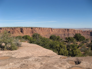
All desert trips must come to an end, it seems.  We slept in a little Tuesday morning, then walked to the Moab Diner for breakfast (oatmeal, hash browns, English muffin with peanut butter and fruit).  We cleared out of our motel room and drove up to Dead Horse Point State Park.  The skies were mostly clear, just some light, thin clouds, and it was cool but not cold at about 54 F.  There were a few other cars in the parking lot with MTBers getting ready to hit the trails. 


Once we got out there, however, we really didn't see more than a handful of other people - just the way we like it.  We did the Big Chief loop, which has a couple of hike-a-bike sections at first but then is rideable and fun for the rest, then across the sagebrush flats on Crossroad to cross the road to the newer trails.

Scenery for days

We were both riding better than we had been and I had my best ride ever on Whiptail and Twisted Tree, never even putting my foot down on Whiptail except to let another rider go by.  Maybe fresher legs (from not doing double sessions the day before) helped?  Regardless, we felt good and it was wonderful to be out there under those desert skies.

I mean, look at that

We finished up our ride and had snacks/beers while people-watching and putting our gear away.  Then it was time to say farewell to Moab once again and, with a stop in Green River at Ray's Tavern for veggie burgers and beers, our desert trip was done.  Until the next time!

Finis

Ride stats:  16.41 miles; 2:21 hours; 7.0 avg. m.p.h.; 16.9 max m.p.h.

Saturday, October 28, 2017

desert trip, part 5

Monday found us with the same routine as the day before, perhaps ten or so minutes later.  Armed with our weird little book, this time we drove into Arches National Park - not very busy yet - and out to Balanced Rock.  We turned left onto the dirt Willow Springs Road and went in about a mile to another intersection (Salt Flat Road) that had a wide turnout for parking.  The south rim of the Eye of the Whale mesa was our goal.

Heading up the wash

After another in-the-truck breakfast of bananas, bagels and peanut butter, we left a "just gone hiking" note on the truck's dash and started off down the Willow Springs Road around 9:30 a.m., noticing the tons of small critter tracks (lizards, mice, squirrels, rabbits and coyotes) in the undisturbed dust.  We walked down to where a wash crossed the road and found a flap pole with an arrow pointing up the wash, indicating foot traffic only.

At the old dam

So up the wash we went, past the remains of an old dam to the first of three cottonwood trees.  It may sound vague but this is verbatim how our book (this time, Forty More One-Day Hikes in the Moab Vicinity) describes this part of the hike: "... into the wash above the damn, then hike up it toward some cottonwood trees, to where it is feasible to climb out on the left to the higher sandstone slopes there.  Explore these at any level, continuing generally toward the northeast, finally ascending to the highest sandstone level."

This is, in fact, the "trail"

And that's what we did, scrambling up on the rock at the first tree.  Once up there we had to watch our step a bit to avoid dry potholes, crevasses, cryptobiotic soils and lichens; we also tried to minimize stepping in any sand to maximize "leave no trace."  There was plenty of sandstone to safely walk on, however, even if we did have to do some backtracking to get around gaps in the rock.

Big spaces in the desert

We worked our way up the terraces as high as we could to the northeast, finally stopping at sandstone domes where we had views of the Klonzo MTB trails, Routes 313 and 191, the LaSals, the Henry Mountains and various features at Arches - truly amazing panoramic views.  We poked around up there for a while, peeking into little oases and gullies among the domes and noting what we presumed were desert bighorn tracks in the sand.

An oasis among the domes

Having kept those cottonwood trees in sight, we were able to make our way back into the wash and out again.  A couple of jeeps passed us as we walked back on the Willow Springs Road, and a couple more went by as we had our post-hike beers.  But that was it: a whole half day in Arches National Park and only seeing a handful of people.  Awesome.

Nice spot for a snack

To be completely honest, we weren't feeling all that inspired to double-session it on the MTBs, so instead we drove out Route 128 and found a spot where we could sit and watch kayakers on the Colorado River and MTBers finishing up the Porcupine Rim trail.  It was a beautiful afternoon, sunny but not hot, and just pleasant to be outside, even if we weren't exerting ourselves all that much.

Our signal cottonwood tree

Our evening plans consisted of getting cleaned up, chatting with the motel staff about living in Moab and finding a place to eat.  We'd intended to go to 98 Center and were disappointed to find that they were closed for a private catering event.  Miguel's Baja Grill is always a good option (if you can get in) but they tend to be a little expensive, especially if margaritas are involved; Peace Tree Cafe was a bit pricier than we were looking for as well.  So back to the brewery which, while not fine dining, gets you a good amount of bang for your buck.  And you can't go wrong with their Johnny's IPA.

Awesome sign (even if "boundary" is spelled wrong)

Hike stats:  6.72 miles with a whopping 700 feet of elevation; 2:23 hours moving, 2.8 avg. speed. 

Great afternoon for a float

Thursday, October 26, 2017

desert trip, part 4

Up at sunrise in Moab: got organized for hiking and MTBing; stopped at the grocery store for bagels and bananas, coffee, etc.  We drove down the Potash Road (Utah 279) for about 10.5 miles and then parked, as our guidebook (Moab Country Day Hikes: Forty One-Day Hikes in the Moab Vicinity by Fran and Terby Barnes) directed, "at the open end of a huge culvert."  We breakfasted in the truck because it was 37 F in the sun and then, thus sustained, proceeded to get our hike on around 9 a.m.

"At the open end of a huge culvert" for reals

Colorado River view

This book that we've got was written in 1996.  Some things - like walking through the huge culvert to start - have not changed since then.  Other things have.  The book gives vague directions to our destination - Jeep Arch - by going up the Culvert Canyon wash.  Since then, a trail has been signed and cairned for this hike, following the sandstone terraces up looker's-left.  We opted to follow the trail up and then perhaps come back down via the wash; the canyon splits several times and we figured it would be easier to navigate on the way out.

Heading towards those sandstone features

As we made our way up the rock terraces, taking care to avoid cryptobiotic soils, dry potholes and lichens, we had the whole canyon to ourselves.  It was completely quiet, save for a few bird calls, and the views were staggering.  After walking for a while, a sign indicated a loop option, one heading up and one heading down.  We bore left, on the high side, going clockwise on the loop.  We climbed a couple of levels, scrambling a bit to get up between two looming sandstone features, then continued up a shallow wash.

Wide open, dizzying views

Jeep Arch is so named because it is a jeep-shaped cut-out in a massive stone fin.  It's quite big although the stone wall it is in is narrower than I expected, eventually flaring out down canyon.  The loop trail scrambles up one side so you can stand in the arch, and then continues down the other side.  We paused for a few minutes at the arch.  Again, all to ourselves.  Again, staggering views.

Sort of jeep-ish

We completed the rest of the loop and then, back at the sign, H noticed a definite trail coming out of the wash below us.  We figured that this was the old way up and, as such, could be our way down.  We carefully made our way down the drainage, with some route-finding whenever we reached an "impassable pouroff" (per our book).  There was a surprising amount of water still in some deep pools and we guessed that some of these grottoes were pretty popular with locals on hot summer days.

H in Jeep Arch

As we got closer to the mouth of the canyon, we met a few other people.  We also started seeing more birds, including one falcon who seemed indignant at our passing by.  We came back out through the culvert, getting back to the car around 11:30 a.m., just in time for lunch which consisted of beers and hike snacks.

Scrambling up to the arch

After re-organizing for MTBing and a quick trip down to the end of the road, we headed back towards town and up to the MOAB Brand trails for some MTBing.  We were there later than we usually are so the light seemed very different.  Luckily, we had cool temperatures (in the 50s, light breezes, bright sun - not even any clouds over the LaSals) and sparsely-populated trails.  We did our usual loop (Rusty Spur/Bar M loop) twice, then hung out in the parking lots for a bit for beers while H cleaned up the bike chains.  As we were getting ready to go, a family with a couple of little kids rode up to their car beside us.  One little boy exclaimed, "Whew - I did great!"  H asked him if he hit any big jumps.  The kid very seriously replied, "Oh no, I don't do that," and then launched into a full discussion of how they drove all the way from Colorado, while his mom rolled her eyes and we both grinned.

Jeep Arch is pretty big

After that, we returned to the motel, gave Frank the office dog some belly-rubs and were told that whenever we were ready for a new dog of our own, she [Katie, who owns the place and rescues dogs] could hook us up.  Keeping that in mind for the future, we got cleaned up, had a beer at Woody's and then devoured a veggie pizza at Zax to wrap up our day.

The way we came up

Hike stats: 4.36 miles; 1,000 feet of elevation; 2:36 hours total time; 1:58 hours moving, 2.0 avg. m.p.h.

The way we went down

Bike stats:  18.95 miles; 1:36 hours; 11.8 avg. m.p.h.; 20.9 m.p.h. top speed (H, of course)

How could you not smile with a sky like that?


Tuesday, October 24, 2017

desert trip, part 3

Another sunny and cool morning in Fruita found us breakfasting at Camilla's Kaffe (open 7 days/week, breakfast and lunch only), then packing up our room and heading a little way out of town to the Kokopelli trail system.  The trail head was very busy with lots of MTBers buzzing around but once we got out on our trail - we did the Rustler's Loop - we saw no-one.  The trail was great: flowy and mostly hardpack, with fantastic views over the Colorado River.

The Kokopelli trail signs were very funny

We did just one circuit (about six miles) and then moved on to the third major Fruita trail system, Rabbit Valley, not far from the Colorado/Utah border.  The Rabbit Valley trails are mixed-use, having originally been established for dirt bikes and OHVs but with the addition of MTB access with the rise of cycling's popularity.  The singletrack is for MTBs and dirt bikes; doubletrack is for everyone, including ATVs and jeeps.  This means that the trails are a little more chewed up than those that are MTB-only.

Rustler's Loop view (Kokopelli system)

We did a combination of Trail #2 and the Kokopelli Trail, getting out to the state line and back, and passing tons of primitive BLM campsites.  The ride had nice rolling hills but a real mix of surfaces - hardpack, red sand, gravel, loose rock and slickrock.  Sand usually freaks me out but at this point we were riding through so much of it that I started to figure it out: shift down and keep the revs high, relax the deathgrip on the handlebars, stop holding my breath.

Rabbit Valley singletrack

It was also terribly windy, like, crazy windy and the blowing sand got in our eyes and mouths.  By the time we got back on a firmer gravel road, however, I was so grateful to be off the sand that I refused to complain about the headwind, even when it almost stopped me cold.  We had quick beers and sandwiches back at the truck, huddled down beside the wheels to keep out of the wind, and then continued west.

Sandy section

To mix things up just a bit, we took the scenic Route 128 to Moab, past Fisher Towers, through Castle Valley and along the Colorado River.  At this point (midafternoon), all the riverside BLM campgrounds were full; Moab itself was jumping, with NO VACANCY signs at most of the hotels on Main Street.  Made me glad for our reservations.

In another wash, this one rideable

We checked in at the Kokopelli Lodge (we figured this was our tenth time staying there!) and did our usual clean-up/do laundry/put together a plan for the next day before walking to the Moab Brewery.  It was super-busy as usual but we scored seats at the bar pretty quickly.  The bartenders were outstanding, managing the crowds with finesse and good cheer.  We ate (veggie burger and veggie burrito) and enjoyed our beers (Johnny's IPAs) and had a good time people-watching.

Route 128 is scenic all right

The day finished up with us adjourning to the chairs outside our motel room for one more beer whilst wrapped in fleeces, warm hats and wool socks.  That night's forecast was for 30 F and the temperature was falling fast.

Ride stats:  14.9 miles total (both rides); 2:05 hours; 7.1 avg. m.p.h., 23.3 max. m.p.h.

Sunday, October 22, 2017

desert trip, part 2

It dawned bright, sunny and chilly in Fruita Friday morning and once we'd donned our fleeces and warm hats, we strolled back into town for bagels and coffee at the Aspen Street Coffee shop, located in a historic bank building.  By 9:30 a.m. we were at the southern entrance of the Colorado National Monument - a park H hadn't even known existed until I mentioned that I thought we should check it out.  Looming over Fruita and Grand Junction, this national monument is a quiet gem.  We had no idea that we would spend our whole day there, but we did.

Southern entrance to the CNM

First off, before we were even out of sight of the entrance station, we had parked at the Devil's Kitchen trail head to do some hiking.  We first did the Serpent Trail, the original monument road, twisty with switchbacks; then the out-and-back to Echo Canyon, which had a little bit of everything (sand, slickrock, a tree-shaded wash); and then the quickie up to Devil's Kitchen.  The Serpent Trail had a good number of people on it - it's so close to GJ neighborhoods that a lot of people come just for their morning exercise and then go home - but we amazingly had the other two trails to ourselves.

At the head of Echo Canyon

Echo Canyon trail

H at Devil's Kitchen

After getting our own exercise, we drove the monument's Rim Rock scenic drive (23 miles total) and stopped at almost every scenic turnout and trail head: Cold Shivers point, Red Canyon overlook, Ute Canyon view, Fallen Rock overlook, Upper Utah Canyon view, Highland view, Artists point, the Coke Ovens overlook (we did the one mile roundtrip out to the Coke Ovens features), Monument Canyon view, Grand View, Independence Monument view, Book Cliffs view, Balanced Rock view, etc.

Cold Shivers Point

Red Canyon

We also made note of several hikes, especially the Ute Canyon one, that we thought we might like to come back and do with more time. 

Looking up Ute Canyon

During our time around the drive, we found this sign (below) and were a little puzzled.  What's a half tunnel?  Wouldn't that just be a cave?  (And a zero tunnel would be a wall.) 


In actuality, the Half Tunnel is the site of a tragic construction accident in the 1930s, when nine men died during a collapse while building that portion of the road.  The NPS has a marker commemorating those lives lost.

Looking down Ute Canyon

The Coke Ovens from a distance

We didn't see many critters on our passage through the Colorado National Monument, lots of birds and one desert cottontail as we turned into the visitors' center.  We hit the jackpot, however, just as we went through the tunnels on our way out: a small herd of desert bighorn sheep, grazing roadside.  The park ranger indulgently allowed us to take some photos before politely urging us along - it was a bad place to be stopped on the road.  But, finally - bighorn sheep!

Desert bighorn sheep!

It was nearly 5 p.m. when we left the monument and we were in need of refreshment.  A quick stop at Kannah Creek West (a newer brewpub, somewhat awkwardly placed outside of downtown Fruita in a strip mall) for beers and chips and salsa tided us over.  We got back to the motel, cleaned up and then walked to the park in the center of town for Fruita's last Food Truck Friday.  It was after dark and many of the trucks had started to sell out of stuff but we managed to procure a hummus wrap and a batch of handcut fries to share while live music played up on stage.

Grand Junction from the scenic drive

After eating, we checked out the other "downtown" brewpub, Suds Brothers (originally from Evanston, Wyoming).  It was big and pretty busy but didn't seem to attract the locals that the smaller Copper Club did, just down the street.  So we went back to the Copper Club for a last beer: the bartender remembered us and said welcome back.  The place was hopping but a local couple sat with us and introduced us to about half the bar, including the head of the Fruita Chamber of Commerce and his wife.  When we got invited to a wedding the next day - to which our new friends thought they might bring a hot tub - we felt right at home.


Hike stats: 8.58 total miles; 3:11 moving time at 2.8 avg. m.p.h.; 1,600 feet of elevation.


Friday, October 20, 2017

desert trip, part 1

As any semi-regular reader of this blog knows, H and I try to get away to the Moab area a couple times a year, if we can manage it.  This fall, we managed it and even went a little further afield as well.  Fruita, Colorado, is becoming known as a mountain-biking destination - like Moab, before Moab became what it is today - so we thought we'd go check it out for a couple of days.  It's just across the Utah/Colorado border, about an hour from Moab, so it just seemed like a good idea.

18 Road Trails below the Book Cliffs

We got up early enough that we arrived in Fruita around 11:30 a.m. on Thursday morning.  We found our motel but since it was far too early to check in, stopped in at the Over the Edge Sports bike shop for trail maps.  This was a great bike shop, well-stocked and with super-friendly staff who seemed more than happy to give recommendations for trails, brewpubs and restaurants.  There are three main trail systems in Fruita: 18 Road, Kokopelli and Rabbit Valley.  We intended to give each at least a try to sample what was out there; 18 Road, the closest to town, seemed perfect to start.

On Prime Cut

It took about twenty minutes to get out to the 18 Road trails, first driving through tiny Fruita, then ranch land, then out on a washboarded dirt road through BLM land.  The MTB trailhead is just before the turn-off to the BLM campground (primitive sites with outhouses, no water and no shade) and when we got there, it was fairly busy for a Thursday midday.  There is ATV/dirt biking available on other nearby BLM trails but the 18 Road system is just for MTBs.

So windy that I thought I'd get blown off this ridge

Despite the activity in the parking lot, we scarcely saw anyone once we got out on the trails.  We started uphill on Prime Cut (easy), then went across Frontside (moderate), looking for Western Zippity to make a big loop.  We missed a turn, however, and ended up trying to ride (but mostly pushing our MTBs) down a narrow gully.

In the gully

The gully was technically rideable - just not by me, although H did manage a fair bit of it.  We came out on a dirt road and, with a couple of short climbs, found ourselves back in the campground where we were able to get on the wonderful, flowy Kessel Run to return to the parking lot.  We both agreed that we could have ridden Kessel Run all day, with its hardpack surface and gently-banked corners.

Chillin' in the parking lot afterwards

After that, we ended up hanging out in the parking lot for more than two hours, talking with a #vanlife dude, a group of Quebecois guys out celebrating a fiftieth birthday, and Katie, whose husband was doing the 29+ mile Edge Loop.

It's like it was made for us!

Back in town, we checked into the H Motel (a little small and scruffy but clean and just off Main Street).  We cleaned up and during the two block walk to town, decided that we really liked Fruita.  There are lots of very cute little homes and much of the main street (which is only a couple blocks long, really) is original, preserved buildings, with historical plaques and photographs everywhere so you can see what it used to look like.

The shower was actually huge

Dinner was at the best and busiest place in town: The Hot Tomato Cafe.  We scored seats at the small bar and had local IPAs with a delicious Bob Steve pizza (spinach, artichoke hearts, kalamata olives and tomatoes, but sans cheese).  We chatted with the bartenders and other patrons, including one young woman who noticed H's Sunday River brewpub t-shirt and then confessed that she was a Saddleback girl herself.

Outstanding pizza

When we'd finished, we then got happily distracted by a free open mic night at the Cavalcade community performance space.  There were both adult and high school performers, playing solo or in groups, on drums, electric and acoustic guitars, saxophones and mandolins.  Everyone took it very seriously - from the musicians to the sound guys to the audience members - and it was absolutely delightful.  After listening to several performances, we continued down the block to the Copper Club for a couple of their beers before continuing back to the motel.  First impressions:  Fruita is great!

H uses pedals like that second tap

Ride stats:  8.3 miles; 1 hr. 22 min.; 6.1 m.p.h. moving average (there was a lot of hike-a-bike in that gully); H's max speed 21.8 m.p.h.