Mule deer doe, watching but not worried
We got up at 6 a.m., leaving the house around 6:30 a.m. or so. As we drove up Big Cottonwood Canyon, we were amazed/impressed to see other hikers already parked at the various trailheads; clearly we weren't the only people trying to beat the heat. We parked at the Butler Fork trailhead and continued walking up the road, heading for Mill D. The temperature was very pleasant, cool even, and there were lots of folks out taking advantage, including runners, road cyclists and moose - we caught a glimpse of a mother and her twins heading deeper into the forest from the Big Cottonwood Canyon creek.
Columbine
No matter how often we hike this trail - and it's fairly often because it's pretty and a good workout - I forget how tough it is in spots. It starts pretty steeply from the trailhead until it gets up onto a bench, then continuing more gradually along the drainage under the aspens. From the Dog Lake/Desolation Lake junction, it gets steep again but the trail underfoot is packed dirt, pleasant to walk on, and it is shaded, which is a bonus. After climbing for a while it finally flattens out for a stretch of what H calls possibly his favorite stretch of hiking trail ever. The trail stays in the trees but follows a field up the valley; we saw a mule deer doe on the other side of the creek and she was completely unconcerned with our presence.
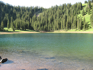
Desolation Lake
It gets a little steeper just before the lake - which is just so pretty, a turquoise color surrounded by the green hills - and then, as we continued past the lake towards the Wasatch Crest Trail on the ridge, it gets steeper still, the long switchbacks helping to eat up elevation. The wildflowers are really ramping up now and we walked through hillsides covered with them: paintbrush, buttercups, columbine, wild roses, sticky geranium, bluebells, fireweed, penstemon and lupine. We reached the Wasatch Crest Trail and walked just a bit further up until we could see over the back side, down into Canyons Resort. This is a view we don't often get and it was interesting to see Park City from that angle.
Canyons
To get to Butler Fork, we had to retrace our steps all the way back down to the Dog Lake/Desolation Lake junction and then hike up to Dog Lake. I know people like that hike - it is very popular with novice hikers (who do not know trail etiquette) because it is not too long - but it is a steep, sweaty, miserable grind straight up the drainage to the lake. Not my favorite. We didn't linger there but continued up past the lake to the left to the Butler Fork trail. This trail is not nearly as heavily used as Dog Lake/Desolation Lake and, as we headed down the drainage, it was quite overgrown with the early summer vegetation well over my head in places. At one point, just as H passed an aspen grove, a young mule deer buck jumped to its feet, startled out of its resting place. If that deer hadn't stood up, we would have walked right by, never knowing it was there, hidden by all the greenery.
So green!
We finished the last, steep and rocky bit of the Butler Fork trail just as H drank the last of his water - just in time. It was unshaded by the truck and we were hot and sweaty but still were able to manage a beer as we changed out of our hiking gear. This was a long hike but due to the early start, the mostly-shaded trail and the finish down through upper Butler Fork, we were able to stay out for a long time without seeing too many people. It was a pretty good critter haul too: the moose, the mule deer, hummingbirds, a small snake and scores of potguts, chipmunks and squirrels.
Perilous stream crossing
Hike stats: 11.32 miles; 2,900 feet elevation gain; total hike time 4:36; moving hike time 3:45.


No comments:
Post a Comment