Monday, September 30, 2019

return to seven mile canyon

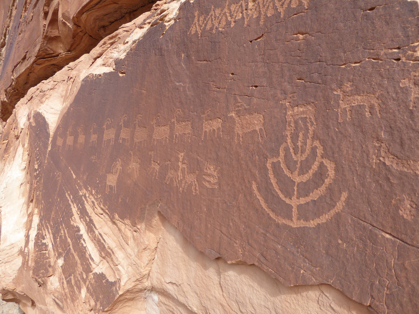
Sunday morning, we drove out Route 313 to Seven Mile Canyon to do the main fork, which we hadn't done since May 2016.  We parked where we did before but before crossing the road to the canyon entrance, we looked for the Intestine Man pictograph.  We were so intent on searching at eye level, where all the other petroglyphs were that we didn't even think to look up.  It wasn't until after our hike that a friendly park service ranger, stationed at the site to talk with people about the rock art, pointed it out to us.  We talked with her for quite a while, learning that this "rock art" is really more visual language than art, and that the Intestine Man is depicting neither a man nor his intestines but more likely an insect and a seasonal passage of time.

Where's them lizards at?

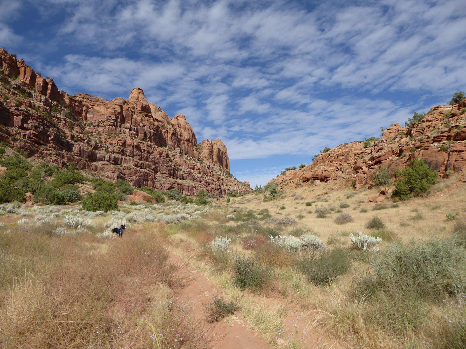
After crossing 313 and going through the gate in the fence (updated from where we had to squeeze past barbed wire in 2016), we went past some additional petroglyph panels before coming out into the broad, sandy wash.  This branch of the canyon is very wide here and very, very sandy.  Walking on this surface was exhausting even though there was negligible elevation gain.

More trees as the canyon narrows

We walked in for 1.5 hours, exploring a couple of side canyons (and noting a couple others for future exploration) and getting past where we'd turned around before.  It was warm, however, and when Milton started sitting down in shady sections, we didn't want to overdo it for him.

This was actually nicer to walk on than all the sand

The return trip was a struggle simply because the deep sand is such a pain to walk in: it actually got frustrating at times, where you had to make a huge effort for small gain.  We think we might go back in the winter, when things have perhaps frozen up a bit and are easier to walk on, plus less concern about overheating, to see if we can get to the end of the canyon.

Taking a break

Hike stats: 6.82 miles; 2:37 / 2.6 m.p.h. moving; 3;13 / 2.1 m.p.h. overall; 480' elevation

Saturday, September 28, 2019

hidden valley petroglyphs

Feeling the need to get to the desert, we drove down after work last Friday, while it was snowing in the higher elevations of the Wasatch mountains and hailing down in our neighborhood.  Things dried up by the time we got to Spanish Fork and traffic was not all that bad.  After rolling into town, we stopped at Woody's for a beer to decompress ... and ran into my aunt and uncle from Minnesota.  We'd known they were in Utah - my uncle had a fishing trip on the upper Green; my aunt had planned on visiting several of Utah's Mighty Five - we just didn't know when they were going to be in Moab.  It was great catching up with them for a couple of hours; we would see them again in SLC Monday afternoon.

Gorgeous morning 

 Milton on the saddle

Since the sun doesn't come up until after 7 a.m. this time of year, we didn't get a real early start Saturday morning.  Trail options are a little limited right now for us: this is high season for Moab so there are a lot more MTBers/jeepers/ATVs out on the trails so we need to   be selective if we want to go off-leash with Milton.  We decided to go back to Hidden Valley to check out the petroglyphs we had missed last time.

This one seems to have a squirrel

We got to the trailhead parking lot around 9:30 a.m.  There were five other vehicles already there but based on the number of hikers we saw, we figure at least two of the cars were MTBers for the Pipeline trail.  We actually timed it perfectly: we only saw two groups of hikers heading out as we were going in, plus one other group just as we got to the petroglyphs.

We have learned that most humanoid figures are not people, 
but representations of insects, plants or seasons

The morning was beautiful with cool, pleasant temperatures, a very light breeze and mostly clear skies.  We let Milton off the leash as soon as we  started going up the rocky ascent.  He stayed pretty close for most of the hike although he was keen on all lizards we saw.  He seems to be a sight hound: he'll chase anything that moves but once a lizard/ground squirrel goes to cover, he loses interest and moves on.

The lines of deer/sheep are my favorites,
possibly denoting the passage of time

Just as we got to the saddle, we stayed right where the trail split.  It climbed a little bit, bringing us to the base of the cliffs where, almost at once, we saw the rock art.  There were hundreds of petroglyphs along the cliff base, with a wide variety of shapes, figures, animals and plants.  We were really able to take out time with them since no one else was up there with us; Milton got a little bored with the pace and scouted out small scurrying things to terrorize.

Chonky boi

We followed the cliffs down, and then kept following the drainage down a little way further towards the Moab Rim trail.  As we looped back around to follow the lightly used jeep road back (we think it doesn't get much wheeled traffic up there because motorized vehicles aren't allowed all the way up to the saddle (thankfully), which preserves Hidden Valley), we saw three groups of hikers perusing the petroglyphs where we had been.

These are all estimated to be 7,000-12,000 years old

Still more people were coming in as we headed out, so our timing had been very good.  It was 12:40 p.m. when we got back to the car.  Milton hung out under a truck in the shade until more dogs and people showed up - then he worked the crowd.  Everyone likes Milton.

Love this one's split hooves!

We got back in time to put together some lunch, clean up, hang out a bit and then walk to Woody's for beers before returning home for dinner.  After dark, we attempted to sit out to star-gaze since it was so clear.  It was also so cold so we didn't last long.

Boys heading out

Hike stats:  5.7 miles; 2.0 m.p.h. moving / 1.7 m.p.h. overall; 3 hours 10 minutes


Tuesday, September 24, 2019

placeholder

We escaped to Moab for the weekend and are still sorting through the photos and the laundry because we then had houseguests.  So real posting is slightly delayed until we can get our heads on straight. 

Until then, please enjoy this photo of a wild juniper bush in full berry:


Saturday, September 21, 2019

good day for a ride

It seemed like it had been ages since we'd MTBed in Park City, although really it had only been a couple of weeks.  It was absolutely gorgeous when we rolled in to Round Valley: bright sunshine, clear skies and temperatures around 58 F.  We'd waited a while for things to warm up before we headed out; Park City was in the 30s when the sun came up that day.

 Spectacular day

Although the Quinn's Trailhead parking areas were pretty full, this was for youth soccer and lacrosse games and the trails themselves were not that crowded in the morning.  There were quite a few dogs and walkers but only a few MTBers and trail runners.  The trails were in pretty good shape too: there were a couple of wet and muddy spots but for the most part everything had dried up from the deluge northern Utah had gotten a few days earlier.  The dust was tamped down (or washed away) too so we didn't so much look like Pigpen as we rode along.


Our route this time was the usual start to 7170; the P-Dog Loop (up PorcUClimb and down Down Dog) to Matt's Flat to Rambler; Rambler/Ramble On/Rambler to the Round Valley Connector; around the backside to climb Happy Gilmor and Tin Man (25 minutes of climbing) to Rademan Ridge; and down Rambler.  At this point, my legs were a little fatigued - the stretch of Rambler etc. around to the RV Connector is rockier than our usual trails - so I went right, along the Round Valley Express, bearing left on Valderoad, pushing my MTB up Hammerhead Hill, then riding across 7170 to the road down and out.  H instead rode up the sagebrush switchbacks of Rambler, then down the other side of Rambler to what we call Turn 8, where he turned off onto Kari's (or High Side, one of those) back to Matt's Flat to the way out.  Beautiful day, good ride.


Ride stats:  19.31 miles (this was H's distance as he carries the GPS; my distance was a couple miles shorter, most likely); 2: 03 hours; 9.4 m.p.h. average speed; 26.5 m.p.h. top speed (again, H); 1,390' elevation.

Wednesday, September 18, 2019

millcreek canyon north

We've been spending a lot of time in Millcreek Canyons lately, it seems.  It's Milton's fault: he likes to hike and in the SLC area, Millcreek Canyon is dog-friendly.

Another pretty day in the Wasatch

Milton and I had done the Elbow Fork/Terraces loop earlier this year; Lambs Canyon is only dog-friendly on the Millcreek side; we'd just done Mt. Aire; and Grandeur Peak is not our favorite.  That left the Big Water/historical trail lollipop we'd done in October of last year (and then prior to that in 2016).  We knew it was long-ish but didn't bother to check the hike stats from before.


Fun out, tongue out

We didn't get as early a start as we should have and had to park down the canyon road a ways in a small overflow below the two paved parking areas.  At the trailhead we duly noted the Forest Service sign about an aggressive black bear in the area and then headed out, taking the Old Red Pine Road trail up the drainage.  We saw a few dogs with hikers and trail runners (the day's dog total would end up being 25) but had the trail to ourselves for most of the time.  Milton seemed to be ranging a little further afield, not doubt distracted by all the dog and critter smells.  But he still came when called and would come back to check on us regularly.

Field of sunflowers up on the ridge

When we got to the ridge dividing the Wasatch Front (SLC side) and the Wasatch Back (Park City side), the Heber Valley was hazy, obscured with drifting wildfire smoke.  We turned onto the Great Western Trail and started climbing towards Desolation Lake.  Here we encountered a couple of MTBers and some trail runners; this trail is so much rockier that I can't imagine riding it is all that much fun.

I love the rose color of these paintbrushes

Before we got to Desolation Lake, we turned right onto the historical trail (still unnamed and unmarked) and quickly descended into the drainage.  We saw only one hiker, loaded down with a heavy pack and looking for a quiet place to camp.  The last vestiges of the summer wildflowers spotted the meadows with faded color.  It was quiet and pretty.  And Milton had a blast chasing birds.

So.  Tired.

We kept heading down-canyon when we met back up with the Big Water/GWT trail.  This section is always longer than I remember but shaded and pleasant to walk.  A final turn down the steep and dusty Dog Lake trail - with lots of dogs and their people - and then we were down.  Milton would have kept going and going and going ... but when we got back to the car (and took his harness, now filthy after just two hikes, off), he zonked out immediately.  Since he runs at least 1.5 miles further than we hike, this was his longest hike to date.


Hike stats:  10.03 miles; 3:13 / 3.1 m.p.h. moving; 3:48 / 2.6 m.p.h. overall; 1,880' climbing

Sunday, September 15, 2019

long weekend: millcreek, main fork

On Labor Day itself, we slept in just a little and then drove over to Millcreek Canyon to hike its main (and less popular) fork.  Even so far into the summer there was still plenty of water flowing all through the canyon and it felt refreshing - but not at all cold - to walk in it.

Sun coming up over the canyon walls

Milton got to be off-leash and proved that he really likes creek hiking: he was getting his crazy on, leaping and plunging into the water.  As the sun rose in the sky, we walked upstream as the canyon changed from narrow and tree-choked, to wide open and sandy, to cottonwood-shaded grassy meadows.  We saw only a couple of people but the trail was clear and easy to follow.

Downstream

We walked until we came to a fence marking passage through private property, where we could have continued on to the Steel Bender jeep road.  There were some petroglyphs on the canyon wall here, which we were alerted to by the sign on the hitching post: Leave horses here when looking at rock art.  We also met a couple with a dog who had come via jeep; the woman called Milton handsome.

Upstream

As we headed back down the canyon, we hiked back along the cliffs for a ways instead of sticking to the creek.  It was up against the canyon walls that we found caves and an archeological site/native burial ground.  We hadn't even realized it was there when we walked by the first time.

Absolutely enjoying himself

The sun was pretty much overhead at this point and our all-black dog was starting to overheat.  The trail was staying near the cliffs and in the sun so at the first drainage we found, we went back down to the creek and just walked in the water until everyone cooled off.

The course of the water has carved out soaking pools

We even found a couple of deep (over my waist) holes where I waded in to see if Milton knew how to swim.  He doesn't, quite, so that's something to work on.  He still enjoyed wading and jumping in shallower sections, though.

The only deer we saw

We knew we were getting back to to the mouth of the canyon when we started to run into other people enjoying the creek's deeper pools.  Milton wanted to meet all of them and it was tough to convince him to keep walking with us when there were so many other people to pet him.

Ancient native site

When we got back, we had lunch, cleaned up and got on the road around 3:30 p.m., with no little trepidation about what the holiday traffic might be like.  It was actually fine most of the way but with only ten miles to go in Spanish Fork canyon, it came to a near standstill.  We were only really delayed about forty minutes and things loosened up again once we got on I-15.  It's always worth getting away, even if you do have to deal with holiday traffic.

Gorgeous day to finish the long weekend

Hike stats: 8.61 miles; 3:11 / 2.7 m.p.h. moving; 3:44 / 2.3 m.p.h. overall; 960' of climbinb

Thursday, September 12, 2019

long weekend: clark lake loop

We were out Saturday morning a little before 8 a.m., heading up to the La Sals with Milton for a hike.  Once again we drove up the increasingly-rutted Geyser Pass Road (the shuttles for the Whole Enchilada go up and down a lot, and quickly, which doesn't help the road's condition) to the Squaw Springs trailhead.  This time we crossed the road to the Boren Mesa trail, which would take us to the Clark Lake loop.

Cornering quickly

As soon as we got away from the road, we took Milton off-leash.  He was pretty stoked about that but was good about coming back to us when called and checking in when he got too far ahead.  We did put him back on the leash when we encountered range cows, just to keep everyone safe.

How now, black cow?

The trail was pretty beaten up by the aforementioned range cattle.  We followed it through aspen groves, mountain meadows, short stretches of dark forest and across a couple of creeks.  Right before we saw our first (and remarkably brave) cows, we heard an elk bugle off in the distance. 

Old log / new life in Clark Lake

After crossing the mesa (more cows), we came to the trail junction with the Clark Lake loop.  We went right, doing the loop counter-clockwise, descending through more aspens to little Clark Lake.  (All the "lakes" in this area - Clark Lake, Oowah Lake, Warner Lake - really seem more like ponds to me.)  There were lots of fish jumping.

The boys at Clark Lake

As we descended further - realizing that we would soon have to climb back up all that lost elevation - into Oowah Lake, we started to see other people.  Oowah Lake has campsites so it is accessible by car, so it is a lot busier than where we'd just been.  We didn't linger long there, having been spoiled by the quiet solitude up on the mesa.

View from Boren Mesa

The climb out of Oowah Lake was steep but soon enough we were back at the trail junction where we bore right to retrace our steps on the Boren Mesa trail.  This time, as we crossed the mesa, H caught a glimpse of an elk before it shyly disappeared into the gambel oaks.  We don't see them very often as they're leery of people.

Getting his new harness dirty

Back at the truck, Milt took a power nap in the dirt.  We didn't linger long over our post-hike beers, however; what with all the range cattle traffic (and leave-behinds), there were too many flies.  We dusted off the dog and went back to town.

When H got back from his evening MTB at Moab Brand Trails, we put some dinner and beers in a cooler.  We drove up to the Sand Flats Recreation Area and parked at the Slickrock trailhead lot, climbing into the back of the truck to watch the sun set and the stars come out.  It wasn't quite as peaceful as we had hoped: there was a lot of traffic on the Sand Flats road with ATVs coming off the slickrock, light bars blazing; and there was a ranger who kept circulating, politely telling us that no camping was allowed in the parking lot.  Star gazing was allowed, though, and once the light had gone out of the sky, the stars were amazing.

Sunset over the Sand Flats

Hike stats: 6.87 miles; 2:33/2.7 m.p.h. moving average; 3:17/2.1 overall average; 1,550' elevation

Monday, September 9, 2019

long weekend: mtb

We were lucky enough to take the Friday before Labor Day off so, with an extra long weekend at hand, we drove down to Moab Thursday night.  (Yes, there has been a lot of Moab this year. Expect more of the same.)  We got into town about 8:45-ish, having gotten caught in traffic on I-15 between Lehi and Provo due to both an accident and increased traffic for the college football game.  After the drive, we needed to decompress just a bit and walked over to Woody's for a beer.  The bartender was quite surprised to see us out after the sun went down.  But not so surprised that she didn't remember what beer we drink.

 Rusty Spur

Friday morning found us on the dirt at the Moab Brand Trails around 8:30 a.m.  We decided to change things up just a little this time.  We still started out on Rusty Spur to warm up, then followed the Bar M loop just to the Bar B/Rockin A/Bar M junction.  We turned right to do Bar B counter-clockwise.  We'd never done this one before: it was more technical than our usual route, especially as we made our way down into the washes, but it had a nice long climb on a old road on the back half.  We also found a back entrance to Arches National Park.  No bikes allowed off-road in the park so we'll have to go back to explore on foot sometime.

Canyon next to the Rockin A trail

Back at the Bar B/Rockin A/Bar M intersection, we turned right and went out on Rockin A.  This trail we've done once before, back in 2012.  It seems to be one of the older trails in the Moab Brand system and is all on the slickrock skirting a pretty little canyon.  The first two-thirds were great and fun to ride but the last bit was more technical than either of us was comfortable with and we ended up walking a bunch of it.  We finally reconnected with the Bar M trail at the Circle O junction (we plan to give the Circle O a try another day) and finished the Bar M loop.  When we got back to the parking lot, we took the cut-off across, back to the Bar M, and did that half of the trail in reverse direction to what we normally do.  There's more climbing that way, for what it's worth.  It was getting hot at that point so we didn't linger too long over post-ride beers.

Ride stats:  16.66 miles; 2:24/6.9 m.p.h. (because of all the walking); 22.9 m.p.h. H's max speed

On Saturday, after our hike (more on that later), H took his MTB back to Moab Brand Trails to get some more miles in.  It was hot - although the temperature dropped consistently while he was out there - and he had the place to himself.  He said that the different angle of the light made everything really pretty: usually we're there as the sun comes up, not as it's going down.

A distant Arches National Park in the evening light

Ride stats: 15.92 miles; 1:24/11.3 avg. m.p.h.; 22.2 max speed

Our final ride of the weekend was on Sunday, up at Dead Horse Point State Park.  We didn't leave until close to 8 a.m. and there were about a dozen vehicles already in the parking lot, including two guided tours.  Once we got past a couple of groups on the Big Chief loop, however, we really didn't have to deal with many other riders.  It was a beautiful morning and we both felt like we were riding pretty well.  H has new tires and found that his cornering, especially on Whiptail and Twisted Tree, was much better.  I thought I had ridden out too fast (for me) on the front end, trying to put some distance between myself and some other MTBers but after a snack, I found plenty of strength in my legs for the second half of the ride.  Gorgeous morning, good riding, entertaining people-watching during post-ride parking lot beers.  It's all good.

Whiptail trail

Ride stats:  16.67 miles; 2:02/8.2 average m.p.h.; 17.9 max speed

Friday, September 6, 2019

highlight reel, part 1

In thinking back over our first ten years in Utah, I've enjoyed revisiting some of the highlights.  (Also, it's been kind of rainy so we've been stuck inside not having new adventures.)   Here's some from the way-back machine:

October 2009 through September 2010.  We arrived in Salt Lake City!  We skied around at several different ski resorts before deciding we liked Alta best.  We climbed Timpanogos for the first time via the Timpanoeke trail.  We saw mountain goats on Ben Lomond.

October 2010 through September 2011.  We got the best winter to date, with 723.5 inches of snow, which we put to good use with our Alta season passes.  We went to Zion National Park and St. George.  We got MTBs.  We went out to the Trout Creek Ranger Station for our tenth wedding anniversary.  We started going to Moab.


town and country

Millcreek Canyon in Salt Lake City isn't somewhere we've tended to go a whole lot.  Being so close to the urban center, it is heavily used and parking can be an issue if you don't go early.  (We go early.)  But, unlike Big Cottonwood Canyon and Little Cottonwood Canyon (becoming exponentially more heavily used themselves), Millcreek Canyon allows dogs.  Since we now have a dog who loves to hike, we headed up there one Sunday morning.

 Hark! A squirrel!

Millcreek Canyon is organized to accommodate both dogs and MTBers: on odd-numbered days, dogs are allowed to be off-leash on all trails; on even-numbered days, MTBs are allowed on the upper canyon trails (Big Water, Little Water and Great Western).  Bikes are always allowed on the Pipeline Trail, even on off-leash days, so be aware.

Views for days

And then there's us

We drove up to the small Elbow Fork parking area and nabbed a spot there for a hike up Mt. Aire, which we haven't done since 2015.  Once we got up the trail a bit, we let Milton off his leash.  He stuck to the trail really well - no doubt attuned to all the dog smells - and only charged off into the underbrush occasionally after squirrels.  The Mt. Aire trail is steep (like most Millcreek Canyon trails) but it's generally pleasant to walk on: it's mostly packed dirt until you get to the saddle, where it gets rockier up to the summit, and it's mostly shaded too.

The boys checking out the scenery

Amazingly, we didn't have to contend with many people, with just a few around on our way up, no-one out on the rocky summit ridge with us, and a few more on our way down.  Milton got to meet several nice dogs and was very well-behaved; he would say hi, check in with their people for possible pats and then continue on his way.  He even got complimented on his dashing red bandana.

It's important to stay hydrated

When we got back down to the car, the parking area had filled in and there were people coming and going.  We didn't linger there too long, just long enough for the Campfire Lounge to open its dog-friendly patio.  The guy at the gate checked Milton's rabies tag and then brought him a dish of water as soon as we sat down.  We were the first ones there but before too long, other folks and their dogs rolled in.  Milton was pretty tired from the morning's hike: he stood up to greet everyone but otherwise crashed out under our table.  What a good boy: adventure dog and city dog!

Trying not to fall asleep on the Campfire Lounge patio

Hike stats:  3.87 miles; moving 1:57, 2.0 m.p.h.; overall 2:59, 1.3 m.p.h; 2,000' elevation