Friday, August 31, 2018

shadow lake

We headed back to Park City Sunday morning - for people who really hate driving through Parley's Canyon on I-80, we have been doing it a lot lately - getting out of the drifting wildfire smoke and meeting P for a hike.  Our goal was Shadow Lake, tucked under the Jupiter chair lift, way in the back of PCMR.  We had told P that the last time we did this hike, it was over twelve miles.  He was undeterred.

Mom: nom nom nom

Baby: nom nom nom

Skies were clear and temperatures were cool, but not cool enough for gloves or arm warmers, as we left the parking lot around 8 a.m.  As we walked down the road past the golf course to the Silver Star trailhead, we stopped to watch a moose and her calf contentedly browsing among the landscaping.  They were completely unconcerned about us. 

Gorgeous trail

We hopped on the Armstrong trail, thinking that it was the trail we took last fall.  It wasn't - that was Dawn's Trail - and it ended up taking us way out of the resort boundaries, to Canyons territory.  We didn't really care, though, because the Armstrong trail is one of the nicest - if not the nicest - hiking trails we've ever been on.  It is a multi-use trail (MTB uphill only; all other traffic two-way), with no rocks or roots, firmly packed dirt and long switchbacks.  We were climbing the whole way but it scarcely felt like it.

Oh my heck: here comes autumn!

At the top of the climb, we turned left onto the Mid-Mountain trail, which took us under the Quicksilver gondola that links PCMR and Canyons.  At the next junction, we turned right, following Spiro/Powerline straight up the drainage, past the Thaynes mine to little Shadow Lake.  No wildlife other than birds and a few MTBers, but after the morning's moose, we couldn't complain.

Mining ruin

After a short snack break, we started our return trip, walking down the access road to the Thaynes mine.  PCMR is riddled with trails and we had choices on the way out, picking the Mid-Mountain to Crescent Mine Grade to the front of the resort.  We encountered lots more MTBers at this point: some kicking ass and riding uphill, others taking the easier way of just downhilling after a chair lift ride.

On the shore of Shadow Lake

From there, we lost a lot of elevation descending Eagle with its many, many switchbacks, then a short stint on Spiro brought us back to the Silver Spur trailhead.  It was warmer down at the base in the sun, but there was a gentle breeze that kept it from getting too hot as we re-hydrated in the parking lot.  It was pretty busy there, midday, with lots and lots of bikers coming and going, heading to the trails or out on the roads.  And why not?  Those PCMR trails are an awful lot of fun, on foot or on wheels.

Cruisin' down the trail

Hike stats:  13.60 miles; 4:22 moving time; 3.1 m.p.h moving average; 5:15 total time; 2.6 m.p.h. overall average; 2,300 feet of climbing


Tuesday, August 28, 2018

new shoes

The western wildfires' drifting smoke is continuing to make it very smoky in the Salt Lake Valley.  Luckily, it is much less so on the Park City side of the Wasatch mountains, so we made arrangements to meet P Saturday morning at 8 a.m. at Round Valley's Quinn's Trailhead.  We hadn't realized that the National Ability Center was having its 2018 Summit Challenge ride then, so parking was a little crazy; we got redirected out to the U.S. Ski and Snowboard Team facility (sadly, no Mikaela Shiffrin sightings) and parked there instead. 

Voila: new tires!

With so many people doing the NAC ride out on the roads, the Round Valley trails were relatively deserted.  The weather was beautiful - sunny but with a cool breeze - and several of the folks we saw riding with their dogs (including two women on horses and accompanied by Nugget the corgi). 


The gang, post-ride

I was debuting new tires - I somehow wear my treads out quickly, despite not riding all that much: big chunky treads and wider tires (2.5 vs the 2.1 I had before).  H was very pleased with how the bigger tires made my little old MTB look.  The hefty treads gripped the trails great and I had no spin outs, not even in the looser stuff.  These bigger tires are a little heavier, though, so it will take me a couple of rides to get used to that.  Some of our climbs included the former My Nemesis, up the Sagebrush Switchbacks and the first eight switchbacks of the Sweet Sixteen.  Verdict: new treads equals good climbing. 


After our ride, we hung out in the parking lot for beers and snacks and talked with various folks rolling in, including a NAC rider on a fat bike with a sweet flask holder attached to his front fork; and woman MTBing with her very sweet rescue dog, Siskiyou, who just leaned against us while we patted her. 


When we got back home, the smoke had cleared out and it was a lovely evening, prompting us to walk to dinner (pizza), then stop for drinks with neighbors as the nearly-full moon come up over the mountains.  An excellent day (that also happened to be our seventeenth wedding anniversary)!

Saturday, August 25, 2018

return to brighton ridge run

When H and I last did the Brighton Ridge Run, we then remarked that we thought our friend P would like that hike when he got out to Utah.  On Sunday, we arranged to meet him in the Brighton parking lot at 7 a.m. and take him around the route.  From Midway, he was able to come up and over Guardsman Pass, avoiding the highway entirely.

Oh deer

One of the reasons we thought he'd like this hike was because we have always seen a lot of wildlife there and this time was no mistake.  In the cool (43 F) morning temperatures, as the sun was just coming up over the mountains and through the lingering wildfire smoke, we saw 10-12 mule deer, including a couple of good sized bucks and lots of does with fawns.  We also saw a lot of pikas (all of whom scolded us incessantly) and several hawks, who were having fun riding the updrafts.

A and H, top of Clayton Peak

And P and H, top of Clayton Peak

The views are usually spectacular on this hike, where you can see where you're going and where you've been all the way around, not to mention about seven different ski reasons and Mt. Timpanogos.  This time, however, the smoke from local and California wildfires made it difficult to see anything much further than Big and Little Cottonwood Canyons. We did get a break in the haze for a while, though, hence the blue skies in a couple of these photos.

H at The Nook on Preston Peak

We started at Brighton, went to the top of Clayton Peak and then backtracked a little to the top of the Snake Creek Express chair.  From there, we found a faint trail that took us to the top of Preston Peak and then down to the Crest Express chair.  Finding this faint trail was a HUGE bonus: the last time we did this, we went far out of our way on the access road to get to the top of Crest Express.  This faint trail saved us about a half hour of walking.

Looking at Sunset Peak from Pioneer Peak

As has happened before, we had to do a little route-finding along Pioneer Ridge to Sunset Peak.  Because so few people do this section, the trail is very faint.  It is sandy and loose footing too, and very steep in spots, with some definite no-fall zones.  The key is to go slowly, looking ahead, and not to worry.

A and P on the final approach to Sunset Peak

There were a fair number of people atop Sunset, as well as down lower on Catherine's Pass.  We had the option of heading out there - going back down to Brighton past Lakes Catherine, Martha and Mary - but it was decided that we would keep going and finish the loop.  So up we went, first Tuscarora, then Wolverine.

P in the meadow below Twin Lakes Pass

We chatted briefly with a couple of Forest Service rangers as they lunched on Wolverine, then continued around the cirque and down to Twin Lakes Pass.  Here we took the steeper (and possibly not official) trail down the meadow's bowl and walked out along the shore of the reservoir.  Then, only the last bit remained: to walk down the access road to Brighton base.  Since the air temperature was relatively cool, this section wasn't the hot, baking slog it often is.

Cheers for post-hike beers!

There was a fair amount of action happening at Brighton base: a little flea market, cruising motorcycles, people lunching, hikers and trail runners coming and going. We ate our own lunches off in our own little corner and then bid adieu to P.  Hopefully he'll be willing to hike with us again: nearly ten miles, mostly above 10,000 feet, is not easy, especially for someone who was living at sea level less than a month ago!


Hike stats:  9.81 miles; 2.0 m.p.h. moving average; 7:20 total time; 4,060 feet of climbing


Wednesday, August 22, 2018

mtbing midway

Undeterred by the fact that he's only been in the state for three weeks or so, we asked P to find a MTB ride for Saturday morning.  He more than rose to the task: he's renting a fantastic little apartment in Midway and there are Wasatch Mountain State Park MTB trails basically outside his door.  He enlisted his new friends and landlords, C and A, as tour guides; since C has been one of the people putting in all the area MTB trails, he was the perfect person to lead the charge.  And H, who always gets drafted into the tour guide role, was thrilled to just get to ride and not have to make any decisions for a change.

Fun trails

We got over to Midway around 9 a.m. and were on the trails shortly thereafter.  I am not kidding when I say there are trails right out P's door and they are fantastic.  Almost entirely packed dirt, with very few rocky sections or roots, both climbing up the hillsides as well as winding through the sage brush meadows.  We five rode for a couple of hours and knocked off around thirteen miles, then adjourned back at P's nicely shaded decks for beers and stories.  C and A's Australian cattle dog, Violet, kept an eye on everyone from her spot under the table.

Loved the climbing

P has found a beautiful spot out in Midway and since we've just scratched the surface on the trails out there, I predict more excellent rides to come.  How nice to explore somewhere new!


Sunday, August 19, 2018

and onto the wasatch back

Sunday morning, the air in the Salt Lake valley smelled like a campfire - from the area/California wildfire smoke - so we were glad to throw our MTBs on the truck and drive over to Park City.  It had been more than a month (!!!) since we had been on our MTBs; I hoped I remembered how.

P, taking a corner

Because we planned to watch the end of the Tour of Utah, we met P at the Park City high school parking lot, then rode the bike path out of town to the Quinn's trail head.  The air was pretty warm but every now and again we got a cool-ish breeze.  The trails were extremely dusty since there hasn't been any appreciable rain in I-don't-know-how-long.  There weren't many cars at the trail head, however, and we saw very few people out on the trails.

A, same corner but slower


To ease back into things, we took it relatively easy, not making P climb too much his first time out with us.  We did do PorcUclimb (still my new favorite) and Down Dog, and the top half of Rambler's Sweet Sixteen switchbacks, and did the long downhill on Rusty Shovel, among others.  It felt good to get back on my MTB although I do need to get new treads; I've never replaced my front tire and even my rear tire, which has been replaced once, is getting thin.

A breakaway right at the start of Stage 6

When we started back to town, we managed to time it just right to see the Tour of Utah riders heading out.  There was a neutral start in town and then, just before they neared where we were, the neutral zone ended.  By the time they hit that first corner, they were flying: a couple of riders out front already and the rest of the peloton whooshing by.

... and then here come the rest of them

After they had ridden out of sight, we rode back to our trucks, got cleaned up and had a quick lunch.  We jumped the free Park City shuttle and rode it into the old town.  Although we knew we were hours away from the finish, the crowds still seemed diminished from years past.  We whiled away the time at the bar in the No Name, talking to the bartender and keeping an eye on the bike race on our phones.  With just minutes to spare, we paid up and stepped back outside - where we were surprised to find that it had rained, dropping the air temperature by a good fifteen degrees, which was lovely -and up to the barricades. 

We watched Sepp Kuss, the Stage winner and the overall ToU winner, come charging up the hill to the finish line, less than ten seconds ahead of the next riders.  Then, after the rest of the riders came through, we grabbed another shuttle back to our trucks, using the time to make plans with P for the next weekend.  No bike race, true, but surely we can find something to do.

Friday, August 17, 2018

return to the (wasatch) front

After being away for the last five, it felt a little weird to stayed based in Salt Lake City for a full weekend.  We tried not to hang around the house much, however (the heat and the wildfire smoke, from both Utah and California fires, made it a bit uncomfortable), instead heading out to the mountains.  Our friend P had moved from Maine to Midway two weeks ago and we hadn't really seen him yet, due to our crazy schedules; we asked him to come over to the Wasatch Front for a hike and a bit of Tour of Utah watching.

Note: Usually I detail the Tour of Utah pretty closely here but we just didn't keep up with it this year, although we did watch the finishes of the last two stages.  Our travel and work schedules just got in the way.

We picked P up at a lot at the intersection of Wasatch Boulevard and 9400 South in Sandy, then drove up Little Cottonwood Canyon (nicely paved now) to Snowbird.  The drifting wildfire smoke had even infiltrated all the way up the canyon, which massively curtailed the views: we couldn't see the Oquirrhs at the other side of the Salt Lake Valley and, from the top of Hidden Peak, we couldn't even see down into Heber.  Thus, not so many photos for this hike.

Thanks to P, an actual photo of H and me together

Deciding to throw P right into the deep end steep-wise, we went up the Peruvian Gulch trail from Snowbird base (very steep, right from the start), then connected with the Peruvian Ridge trail (very steep, right at the end).  There were a few other hikers out, but not many.  We saw pikas and marmots and were able to spot some past-their-prime wildflowers (elephant heads, Lewis's monkeyflower, paintbrush, coneflowers,  gentians), still hanging on despite the hot and dry conditions.

P and me and the smoke-filled Heber Valley

At the summit, we paused for a bit to see what little we could see, then walked down to the tunnel and the Peruvian chairlift for a ride down the hill.  We had plenty of time to go back to the car to change out of our hiking stuff, eat our packed lunches and then walk back up to the finishing area for the last bit of Stage 5.  The crowd didn't seem as big as it sometimes does and we were able to get spots at the railing a little way from the finishing line, with a good view as the cyclists came barreling down the chute.  American Sepp Kuss handily won the stage, nearly 40 seconds ahead of the second-place finisher.

Mineral Basin

Another sign that the crowd wasn't as big as years past: it took us hardly any time to get out of the parking lot and onto the road heading down the canyon.  The smoke grew thicker as we re-entered the valley.  None of us wanted to linger out in it so P headed back to Midway, with plans for MTBing and more Tour of Utah for the next day.

Hike stats: 3.76 miles; 1 hour 48 minutes; 2.1 m.p.h. moving average speed; 2,670 feet climbed

Wednesday, August 15, 2018

under the rim trail (a/k/a the big hike) part 2

We were still at the edge of the burn zone but coming out of it and climbing regularly; closer to the cliff walls we had to go up and over, crossing from one dry drainage to the next.  We were catching some breezes up at each crest but the ascents were hot; although the forecast for the park had been 83F, it was closer to 90F down under the rim.

Six hours in

With these temperatures hotter than we expected (or hoped), the heat began to take its toll.  We were fine for water but the heat made us disinclined to eat and our empty stomachs soon became upset stomachs.  At hour 7, 15.31 miles in, we decided to stop for thirty minutes, to sit in the shade and try to eat a little.  After that, the plan was to stop every half hour for five minutes, in whatever shade we could find.  This helped, for sure, although we still didn't feel like eating.

Still enjoying the views, despite the heat

At this point, there was no way we were backtracking to the Sheep Creek connector to bail out.  Hour 8/16.81 miles came and went.  At 2:13 p.m., we passed the Yellow Creek campsite (17.41 miles) and saw six campers hanging out.  They had obviously come down from the Bryce Point side, an easy 5.5 mile downhill walk. Although the tiny creek was flowing, the park service had posted signs warning people to boil any creek water as there had been reports of E. coli (!!).  We kept walking, drinking down our own water, warm but uncontaminated.

That just looks hot, doesn't it?

We then left the drainage, walking through a very hot and dry sagebrush section as we rounded the end of the bluff, then started up the final drainage that would take us to Bryce Point.  For some time we were walking in the shade of big trees, on well-packed dirt, and we felt pretty good.

Coming around the end before heading up the final drainage

The last couple of miles - whew!  Those were rough.  We left the shade of the trees and started climbing in earnest.  The trail was totally exposed, although since we were nearing civilization, it was broad and smooth, easy walking if you haven't already done 21 miles.

The Hat Shop (I think, or in the vicinity)

As we got higher, the scenery got dramatic once again; we crossed a gorgeous ridge (the Hat Shop) and continued up the switchbacks, ever nearing the rim.  At about 10 hours and 20.99 miles, we passed three hikers - clean and fresh in brand-new clothes - who were exploring this end of the UtR trail and kept going, up up up.

Just got to get there now

By now, H was just focused on walking, one foot in front of the other, ignoring the blisters that had built up under his toes.  I was struggling a lot, feeling lightheaded and sick to my stomach, having to stop and lean over my hiking poles on every switchback corner.  At one point I shouted "HEY!" to H, who was up ahead a little ways; when he turned to look, I gave him the "time out" sign and then just sat down, right where I was on the trail.  After about five minutes (when no one magically appeared to rescue me), during which time I forced down half a granola bar, I got back up and continued trudging upwards.
Ten hours in/five minute rest

Then, wonderfully, we saw it: a car driving past on its way up to the Bryce Point overlook.  I hadn't realized how close we were since the UtR23 trail comes up on the far side of the ridge; we never even saw the amphitheater.  With the end clearly in sight, we got a last surge of energy and finished in (relatively) good form.  We did not, however, pause our steps to let the tourists take their photos - at that point, we weren't stopping for anything.

I don't look like I'm about to fall over

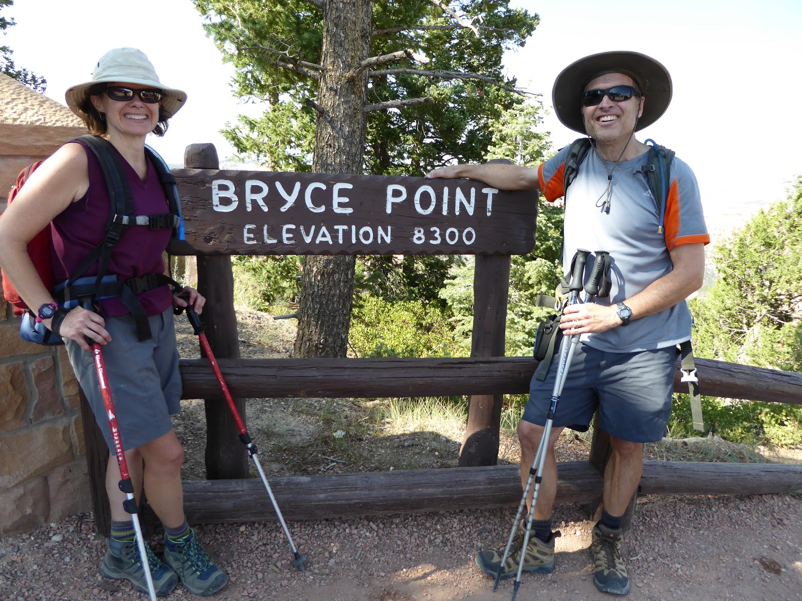
Once at the top, (4:55 p.m.) I could have kissed the Bryce Point sign.  Instead, we high-fived, got a tourist to take our picture and collapsed gratefully onto the bus seats when the shuttle arrived five minutes later.  We had done it!  We were psyched.  We were tired.

Views for days

We didn't even mind that the shuttle had to make numerous stops before dropping us back at our campground because that meant we got to stay sitting down longer.  When we did get back to our cabin, the first thing we did was pound the Gatorades that we had waiting for us in the cooler.  That brought us back somewhat; showers rejuvenated us further; and then dinner at the Ruby's Inn Cowboy Buffet (unlimited soup and salad bar) helped even more.  Even so, I was asleep before the sun fully went down, although H managed to stay up long enough for some star-gazing.

WE DID IT!!!

The more time went by, the more we appreciated the hike.  (And I especially appreciated the fact that the next morning, H rode his bike all the way back, uphill, to Rainbow Point to collect the truck: when he stopped at the park entrance to explain that the park pass was in the truck and that he was riding back to get it, the ranger raised an eyebrow and just said, "Huh.  That's a long ride." and let him go through.)

Post-hike feet - no blisters!

Once the fatigue dissipated, we ended up in good shape: our backs were a little stiff and H had a couple of blisters (I, amazingly, had none) but we were feeling pretty good.  It's safe to say that we will never do the UtR23 in one day again - perhaps as a two-day overnight camping trip - but we set a goal, trained for and achieved that goal.  And that feels great.

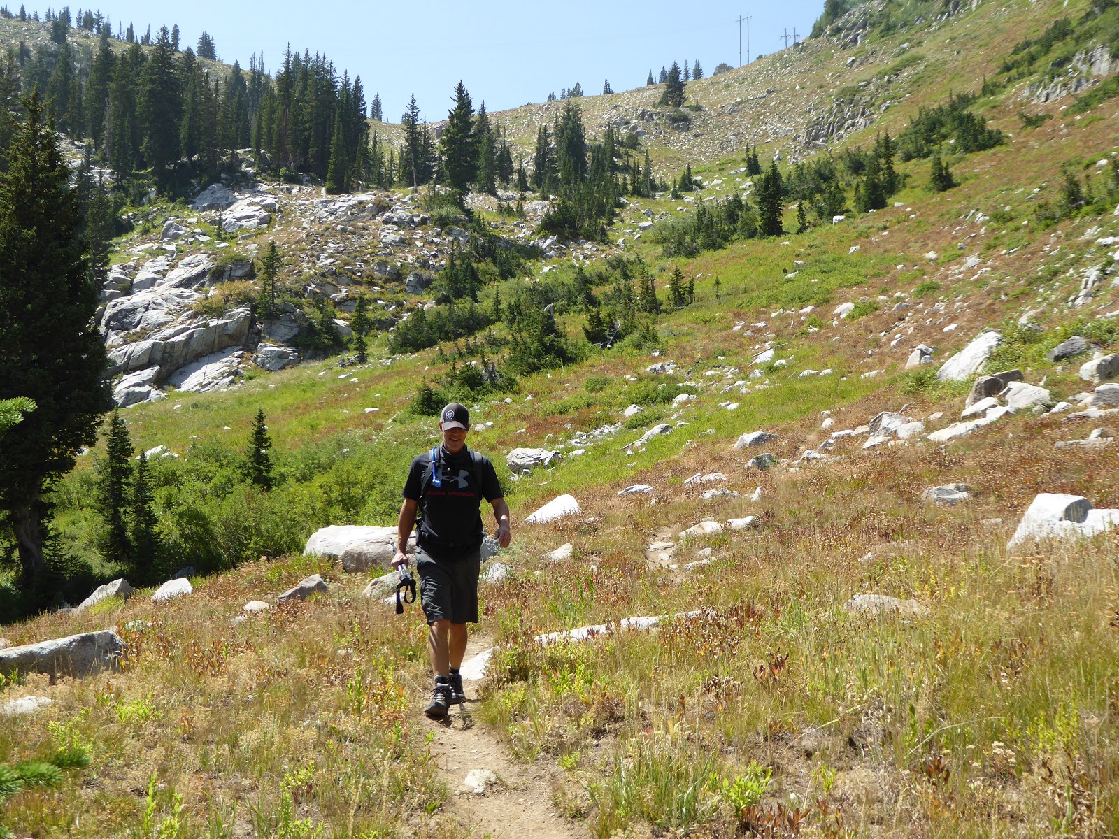
Uphill finishes are always fun

Hike stats: 23 miles with 4,320 feet of elevation; total time 11 hours 5 minutes with 8:18 of hiking and 2:49 of stoppage (even with the extra resting, we finished ahead of what H's initial plan had been: 11 hrs. 24 min.) ; moving average speed 2.7 m.p.h. and overall average speed 2.0 m.p.h.


Couple of different versions of the map


Monday, August 13, 2018

under the rim trail (a/k/a the big hike) part 1

You know how we've been doing long hikes all summer?  It's all been leading up to this, the Big Hike, doing the entire 23 mile Under the Rim trail in one day.  When we were at Bryce last fall with H's parents, we learned about the little-frequented UtR23 - running from Bryce Point to Rainbow Point, all under the rim - and then, after a little research, we learned that while most people do the UtR23 in two or three days as overnight backpacking trips, a few people do it all in one day.  H and I decided that we would be a couple of those people.  The 136 hiking miles we'd done since May were all training.

At the start (with sunglasses because I blink at the flash)

The vast majority of visitors to Bryce stay within the amphitheater area (Sunrise Point, Sunset Point, Inspiration Point and Bryce Point), many staying up on the paved Rim Trail and peering at the scenery from the viewpoints.  Quite a lot venture down into the amphitheater via the short Navajo Loop Trail; some slightly hardier souls will take the Peekaboo Loop Trail from Bryce Point.  A fair number will take their own cars all the way out the 18-mile scenic drive to Rainbow Point, stopping at the overlooks on their way back.  A few will venture out on some of the shorter hiking trails, like the Swamp Canyon/Sheep Creek loop, but Bryce is not a user-friendly park for novice hikers.

One of many blow-downs

Only a handful will attempt the UtR23, due to its length, wilderness status and lack of water.  There are several backcountry campsites along the trail but permits are required.  I had emailed the park, asking if permits were needed for folks attempting to do it in one day.  The answer is no, and you can leave your car overnight at the trailhead, but you'd best be prepared to carry all your water because the few water sources are unreliable.  Thus informed, we were determined to do it although I was really worried about blisters, especially after how beaten up our feet were after the 18-mile hike we'd done in Park City.

HOUR 1

Sun finally hitting the cliffs

We carefully prepared our packs, paring down the weight as best we could since I would be carrying 5L of water and H would be carrying 6L (and water is heavy).  We also mused at length about what food to bring, realizing that we'd need stuff that was packable but not heavy, and that would pack a punch energy-wise but would hopefully sit well in our stomachs.  We ended up with granola bars, KIND apricot and almond bars, sour gummi bears, jerky, honey waffles and a couple different kinds of energy gels.  It seemed heavy on the sweet stuff but we thought it would get us through.  We even managed to think a little about recovery and had some Gatorades sitting in the cooler with the beer.

Crossing a dry creekbed

Monday morning we got up very early, dressed quickly (having laid out everything the night before) and were in the truck at 4:45 a.m.  We got to Rainbow Point around 5:20 ... and then had to wait around for the sun to come up a little so we could see the trail.  There were two other cars already in the parking lot, ostensibly backpackers who had overnighted in the backcountry.

Looking back from whence we came

Pretty glade

By 5:50 we could see enough to start, descending quickly from Rainbow Point.  We had read that there were a lot of blown-down trees across the UtR23 earlier this year.  There were still a lot of blown-down trees across the trail and we had to carefully pick our way across them.  After the first hour of hiking, we had done 2.39 miles and were feeling good.  The air was cool, the rising sun coloring the cliffs under the rim a warm and glowing pink.

Coming up through a burn zone

The funny thing about doing the UtR23 is that, for the most part, you are in the scenery so you don't see quite as much of the scenery which is visible from the rim.  We would follow along at the base of the cliffs for the most part, often in trees, sometimes in meadows, sometimes switchbacking over a rise.  The first landmark per se came at 7:19 a.m., mile 3.56, when we passed the Iron Springs backcountry campsite.  We continued the up and down, scrambling over fallen trees, and at two hours in had ticked off 4.83 miles.  At 8:27 a.m./6.04 miles we had just finished a short climb and passed the currently-closed (for "major trail damage")  Agua Canyon connector trail and at the three hour mark we had put 6.97 miles behind us.

Descending from the Swamp Canyon campsite

We were just under four hours in (and at 7.42 miles) when we saw our first people: two French backpackers who were just putting away their tent after an overnight at the Natural Bridge campsite.  We said good morning, continued on our way and never saw them again.  The trail was pretty pleasant underfoot, a little rocky in spots, a little washed out in others, but often level dirt, the kind of hero surface that makes you think you can walk forever.

Mud Canyon

Mud Canyon the other way

At about 10:30 a.m., we passed the Whiteman connecting trail (the trailhead on the park's scenic drive offers "backcountry parking") and the Swamp Canyon campsite.  We had just entered a large burned area, walking through what is now a meadow with scorched Ponderosa pine trunks.  This was the only one of the backcountry campsites we saw that really had a view: it was located at the crest of a rise and looked out over the spectacular Mud Canyon (terrible name!).  There is no water at the actual campsite but when we continued on the UtR23, we did find a small spring at the bottom of the hill.

HOUR 5

Five hours into the hike, we were approaching the halfway point, having ticked off 11.18 miles.  We also found ourselves on the bit of the UtR23 that we had done on our little hike the day before - familiar territory!  In rapid succession, we passed the Swamp Canyon connector trail (12.14 miles/11:14 a.m.), the Right Fork Swamp Canyon campsite (12.19 miles/11:16 a.m.) and the Sheep Creek connector/campsite (13.30 miles/11:40 a.m).

The way ahead

Now we were past the halfway point in mileage.  Now we were committed, because the Sheep Creek connector was the last chance to bail out - there are no other exit trails until the end at Bryce Point.  Now it was starting to get hot.

To Bryce Point: 9.5 miles
To Rainbow Point: 13.1 miles
Onwards!

To be continued ...