Showing posts with label the best. Show all posts

Saturday, April 27, 2024

let's be frank

 Alta's 2023/2024 ski season has ended with 621 inches of snow.  Not as record-breaking as last year's 903 inches but still well above "normal" (500 inches).  And it ended with a gorgeous closing weekend that likely left quite a few skiers sunburned.

H captures the Castle

H went up solo on Saturday.  You didn't need parking reservations but it was still sparsely attended: he got front row parking.  It was partly/mostly cloudy in the morning, slowing the snow warming a bit, but since it hadn't gotten super-cold overnight, conditions still softened quickly.  Although a bunch of terrain was closed (patrol probably just doesn't want to bother this time of year and who can blame them?), Devil's Castle was open and H went in for the first time all season.  There was plenty of snow but it was heavy to turn in, not surprisingly for this late in in the year.  (Meanwhile, Milton and I did a two hour walk, yardwork, attended to laundry and vacuuming, and meal-prepped down in the valley.)

Closing Day selfie

Sunday was sunny right from the start.  Parking reservations were required for closing day (all parking would be full by 1 p.m. and they actually dropped the avalanche gates to close the road to keep people from coming up).  Staff were checking license plates as vehicles entered the lots, slowing traffic a bit; we got stopped just below the Hellgate condominiums and traffic moved slowly but steadily after that.  We scored a parking spot in the Wildcat base lot - "where the fun is," according to H.  As we walked through the parking lot to the Goldminer's Daughter lodge, the partying had already begun with blaring music, pancakes, eggs and bacon being griddled on camp stove and breakfast beers.

Frank crowd

Later, I saw an Instagram post of the initial Collins lift line, with the caption: "Alta closing goes hard!"  Indeed it does.  I would guess 80-90% of attendees were in costumes.  H and I aren't costume-people but we do appreciate folks' creativity.  We spent the day pointing out good outfits to each other.  There were lots of hotdogs (in honor of the annual Frank Classic free ski competition ensconced up under the Wildcat lift), Hawaiian shirts, bellbottoms, several disco ball helmets, leopard-print everything, tuxedos and wedding dresses, tutus and poodle skirts and lederhosen, chicks in bikinis, dudes in speedos, so many jeans shorts of all lengths, lots of '80s-inspired "fashion," pajamas, robes and wings.

Air Frank

Since folks were so busy pre-gaming, there really weren't many people skiing until 11 a.m.; after that, the lift lines got long, but there was such good people-watching, and it was so sunny and pleasant, that the long waits were fine.  We did our usual progression, following the warming conditions: Sugarloaf (where I fell for the first time in years, catching an edge right under the lift), then Supreme (where H fell for the first time in years, catching a metal soup spoon (?!!?) in his ski brake - it acted like a rudder and steered him towards a ditch until he laid it down to stop himself), then Collins.  We also did the obligatory one chairlift ride up Wildcat to check out Frank.  This lift had the longest lines of the whole resort, as well as a grouchy-looking police officer keeping an eye out for those who were partying too hard.

Photo compliments of our new
locker room friend Johnny

We skied until nearly 2 p.m., then went to the locker room to say goodbye to our locker sublet.  Hopefully we'll get to do that again next year: it was so convenient, plus we really enjoyed making friends with the other denizens.  The party was still bangin' in the parking lot: more music, more food, more beer.  The Oscar Meyer Weinermobile was even there - again, in honor of Frank.  We ate some lunch and grabbed our own beers to do a circuit of the lot, admiring the various set-ups and outfits.  Finally, we had to get home to let Milton out so we said farewell to the ski season and headed back down canyon.  In Frank we trust.

Thursday, April 18, 2024

playing hooky 2

The last time I played hooky to go skiing, it was pretty cold and definitely snowing the whole time.  Not what I had had in mind.  This time, when I needed to get a day in for not skiing on the weekend when it was dumping snow, it was much more what I wanted.  Bright sun, bluebird skies, no wind and hardly any people.

Supreme chair selfie

Going up midweek is just so decadent-feeling, compared to having to get up at 5:30 a.m. to catch a 6:30 a.m. bus.  This time, I slept in until the sun was up, had breakfast, took Milton on a halfway decent walk, and then hopped in the car to go up to Alta.  The drive took me fifteen minutes and I still got up there fifteen minutes before the lifts opened.  And got a dang good parking spot too.

Supreme chair

The thing to do this time of year - when the snow freezes up overnight from being slushy the afternoon before - is start off on the Sugarloaf chair, which gets the most sun and thus softens up the fastest.   When conditions start getting sticky, move to Supreme and then, in the early afternoon, head to the front side.  That's exactly what I did.  Everything was open: there were a good number of folks schlepping up the East Castle traverse; and there was a line of skiers hiking up Baldy.

Partial view of Devil's Castle

Since it wasn't crowded (no little kids and most people seemed to be 60+), I skied right onto the lifts every run, meaning that I made a lot of runs even though I'm pretty slow.  I even ventured into Catherine's Area but should have waited just a little longer before doing so: it was softening but still stiff in spots, making it difficult for me to push through.

Catherine's Area selfie

By 1 p.m., when I got to the front side, the main groomers were nice and soft.  I did make the mistake of going into Sunspot.  It looked okay from the chair but once I got in there, it was still hard and scraped off and I got out and over to Strawberry as soon as I could.  Despite that one sketchy run, it was a fantastic day.  I skied until my legs were tired and didn't get sunburned - so much better than going to work!

Sunday, October 29, 2023

all good things

 Sunday was our last full day.  As I mentioned earlier, we'd talked about going up to Dead Horse Point State Park to MTB since it's been forever since we've been up there.  We talked ourselves out of it, however, given that it's a 45 minute drive each way (with gas prices the way they are), plus we don't have a Utah state parks pass this year.  We still wanted to MTB, though, so we just went to the MOAB Brand Trails which is only a 10-15 minute drive and free.

Not a cloud to be seen

It was a great ride with the same terrific weather we'd been having all week.  We went across the cow pasture (no cows yet) to Rusty Spur, then turned right at the kiosk on the bike path to the 4x4 road, out along the Bar M loop to Bar B, out the road to the Arches National Park boundary (love that climb on the slickrock ramp), back to Bar M with a cut across to pick up the upper half of Lazy EZ, then around the lower half of Lazy EZ, then back across that cut to Bar M again, to the parking lot cutoff.  I haven't MTBed all summer but that ride felt really good.  And even though the parking lot was as busy as we've seen it in a while, we encountered very few people on the trails.  Just the way we like it.

Since it was our last day, after we got cleaned up we walked with Milton over to Josie Wyatt's.  Their patio is dog-friendly (have one person wait at the back gate with the dog while the other person goes to ask the bartender to be let in) - the whole hotel is, actually.  Milton enjoyed himself a lot, from making lots of new friends to having two separate servers bring him bacon.  He didn't want to leave.  (We didn't either and were sad Monday morning when we had to drive back to SLC.)

Sunday, June 11, 2023

jet set

 Oh my heck, where did that week go?!?

In any event, we were down in Moab over Memorial Day weekend.  It was probably crowded but since we stayed away from the parks and didn't go out to eat, it didn't affect us.  H's parents came to visit and we tried to take advantage of the very pleasant weather - sunny, mostly calm and not too hot - with scenic drives through the La Sals and along the Colorado River, picnics at our new favorite picnic spot above the Colorado River ...

The last bit of shade for two hours

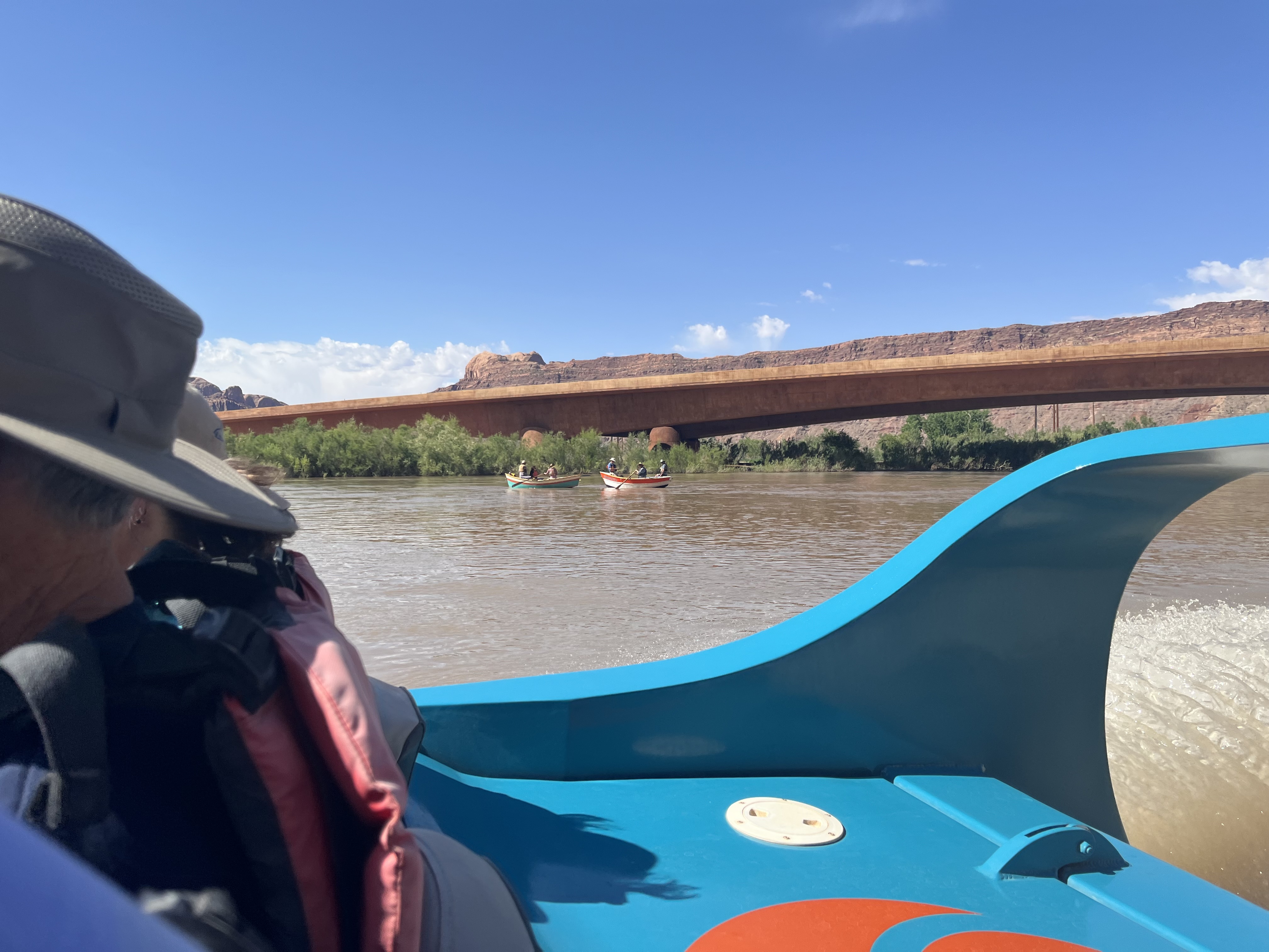
Speaking of the Colorado River, we booked a two-hour scenic river tour with Moab Jett.  We were at the HQ at 9:30 a.m. to sign waivers; once everyone was there (the boats seat ten passengers and besides the four of us there were two other couples, plus Rob, our driver/guide) we loaded up on the shuttle bus for the ride to the river.  They fitted us with life jackets, loaded us aboard and we were off.

Looking upriver

The river was running high (around 36,000 c.f.s.) and fast; anyone who was taking rafting or paddling tours was going to have a quick trip.  We started off downstream, so they could get photos of us coming up under the footbridge, and then roared upstream.  The trip is 26 river miles round trip: thirteen miles up to Red Cliffs Lodge and then back down again.  Rob told us that his primary focus would be safety - since the river was so high, there was quite a lot of floating debris to dodge - but he stopped often to point out features and talk about the area.  He was great.

Couple of wooden dories heading downriver

The highlight was near the Big Bend campground where we spotted a small herd of desert bighorn sheep.  We didn't see any lambs but there were 8-10 sheep on the top of a cliff overlooking the river.  We stopped to watch them for quite some time; our guide was as enamoured with them as we were.

Sure-footed sheep

Because the river was so high, a lot of the usual rocks were far below the surface.  This didn't mean that there weren't any rapids, however.  There were a couple of spots that had some churn to them and when we got to our turnaround spot, there were some standing waves that were at least four feet high.  Rob gave us a tiny taste of what the adventure tour must be like by hitting some of them (in the adventure tour, he said, they often have to stop to bail out the boat) before heading back downriver.

Sheep on a cliff

There was lots more river traffic at this point (nearing noon) and almost everyone seemed to know Rob, who has been driving for Moab Jett for nine years.  Back at the take out, he roared us through a swampy patch before splitting the bridge pylons and bringing us safely back to shore.  The take out was swarming with people now, rafters and kayakers and SUPers and tubers, lots with dogs and everyone keen to get out on the river.  It was nice that we'd had an early trip and had largely had the river to ourselves.

Once ashore, we had a quick parking lot lunch before stopping off for a beer and a trip rehash.  Was it touristy?  Absolutely.  Was it fun?  It was so much fun and we heartily recommend it to anyone.  In fact, both H and I have decided that we're going to have to go back a little later in the summer and do the adventure tour, just to see what that's all about.

TLDR: book a Moab Jett tour - it's worth it!


Friday, May 12, 2023

closing day 2022/2023

Sunday, the closing day of Alta's 2022/2023 season, was nearly opposite from Saturday in every way.  It was bright and clear and sunny, and if it was a little cool ambient temperature-wise, the strong sun made it very pleasant.  And it was crazy-crowded!  As we drove up, traffic was diverted along the bypass road in Snowbird since the main road was still covered in avalanche debris.  What surprised us, however, was that the line of Alta-bound traffic was at a standstill even before we got to the bypass road.  They were checking everyone's parking reservations upon arrival at Alta and since most people wanted to park at Wildcat base - where the big parties are - it was very slow going.  Although H would have preferred to have parked at Wildcat, once we got to the Peruvian Lodge, we were able to get out of that line and drive up to the Albion lot instead, where there were hardly vehicles yet.  The parking attendant checked our license plate and waved us on.  

Yay sunshine!

That wasn't the only long line.  The lift lines weren't bad until 10:15 but after that, the corrals were just swarming with people.  The singles lines weren't too bad, however, since everyone wanted to stand in line with their friends.  With the revellers out in force, there was lots of good people-watching - we reckoned 80% of the people there were wearing costumes - so the lines at least weren't boring.  We even went through the Wildcat double chair once (that was enough): there was a small, half-hearted Frank competition going on but honestly, I think the Alta employees were just too tired to want to build jumps after all the shoveling they've been doing all winter.

That'll take a minute to melt

The skiing was really good too.  Since it had been cloudy and snowing the day before, the snow never melted, so it also didn't set up overnight.  It was soft and fairly quick and didn't get the slightest bit sticky until well after noon.  We skied all over - although we declined to stand in line for the Devil's Castle rope drop - and it was all good, by far the best closing day snow conditions we can remember.

We'd even experienced enough of the party while in the lift lines, so we weren't that upset for a mellow tailgate back at the truck when we were done.  The Albion lot was full and there were lots of folks camped out in lawn chairs, soaking in the sunshine and talking about the record breaking season.  They didn't technically hit 900 inches until after closing day but it was just a few days later when they announced the season snowfall total: 903".  I'm guessing we never see the likes of that again.

Friday, January 7, 2022

red rocks recipe

Since everyone is (I'm sure) clamoring to know, here's the Bloody Mary recipe that H and I have painstakingly crafted.  We like 'em spicy.

                                                One serving                    Four servings

Tomato juice*                            6 oz.                                24 oz. (3 cups)

Ground black pepper                3/4 tsp.                            3 tsp.

Crushed red pepper                  1/4 tsp.                            1 tsp.

Celery salt                               1/4 tsp.                            1 tsp.

Louisiana Hot Sauce                  1 1/2 Tbsp.                      6 Tbsp.

Worcestershire sauce                1/2 Tbsp.                        2 Tbsp.

Lemon juice                              1/2 tsp.                           2 tsp.

Vodka                                        1 1/2 oz.                         6 oz.

Garnishes: olives and pepperoncinis

*  Not V8 (too strongly flavored already and too much sodium)

Monday, June 7, 2021

mary jane slot canyon

 It's starting to get hot in Utah - as I write this, northern Utah is about twenty degrees warmer than it should be for early June, ugh - which means that we have to pick our Milton-friendly hikes with more care: hiking in creeks or up in the mountains where it's cooler.  Since the La Sals have scarcely any snow left on them, we're a little worried about how long the creeks will last this year.  To take advantage while they're still flowing, we decided to head out to Professor Creek and do the Mary Jane slot canyon.  We'd gone out there once before (August 2019) but took the right/dry fork and never made it to the waterfall.  We were waterfall-bound this time.

Look at how gorgeous that is

The ranch road in to the trailhead was terribly washboarded (I thought the doors were going to shake right off the truck) but the parking area has been improved and expanded.  There were only about five other vehicles there when we arrived, although more were coming in behind us, so we wasted no time in getting on the trail.  We actually timed it just right: we were the fifth group in but everyone was spread out so that we had the canyon to ourselves on the inbound leg; and we didn't encounter the hordes until we were on our way out.

Why bother trying to stay dry? 

We did manage to pick the correct fork this time.  It's the one with the creek and you will get your feet wet.  We counted how many times we crossed the creek: 156.  The deepest spot was only calf-deep and it was mostly only up to our ankles.  Milton loved it, running back and forth and splashing and wading and drinking whenever he wanted to.  This trail is off-leash dog-friendly, although we did call him to us whenever we saw someone with their own dog leashed.

Lots of shade all morning

The wash starts out fairly wide open but the canyon narrows and the walls get higher as you head upstream.  The cliff walls are dark red rock and there's pretty good shade.  The waterfall itself is totally shaded and about thirty feet tall, bifurcated around a chockstone.  The creek water is colder up at the waterfall - my toes actually got numb as we were standing there - but it warms up as it moves downstream, over the sun-warmed sand.  Milton didn't much like the waterfall, which echoed loudly off the canyon walls, but H and I loved the cool, mist-filled air.

Mr. "I hate getting my picture taken"

The hike out seemed to go quickly but we were surprised at the number of people coming in.  This hike is not a secret, and we had chosen to come on the Saturday of a long holiday weekend.  When we got back to the truck, the parking lot was overflowing and a Subaru hovered patiently to nab our spot as soon as we could wriggle our way out of it.

So narrow that there's nowhere not in the creek

We ended up stopping at a pull-out along the Colorado River for our sandwiches and beers, although we had to drive almost all the way back to town before we found a spot.  The picnic areas and river launches were packed with people, cars parked along the road for a half mile on either side.  Milton, tired but not overheated, snoozed in the truck while H and I waved to the paddleboarders, kayakers and various tubing flotillas that rode the river current past us.  

Had the waterfall to ourselves

Hike stats:  8.56 miles; 3:17 hours moving/3:32 overall; a whopping 640 feet of elevation

Exploring a side canyon


Wednesday, May 26, 2021

jackson's hole

 No, not that Jackson Hole.  And although all the google searches for the Moab one call it "Jackson Hole," all the signs out on the trail call it "Jackson's Hole" so that's what I'm going to do.  

Colorado River from Jackson's Trail

Since we saw the Mad Moose Behind the Rocks Ultra race , I've been eager to do the accessible portion of their course; since the forecast was for partly cloudy with a high of 77 F, this was our best chance to do it until fall when things cool off again.  We had our route: up Jackson's Trail, down Jackson's Ladder, around Jackson's Not-Hole, up the Ladder and down Amasa Back.  We were out the door at 7 a.m.

Where we're going

There were two other vehicles in the Amasa Back parking lot when we started walking back along the Kane Creek road to the Jackson's Trail trailhead at the OHV trailer lot.  It was cool but not cold, a little humid from being so close to the creek.  We didn't see anybody for the walk along the creek and river (30 minutes) or during the first climb up to the top of the mesa where we crossed the Cliffhanger trail (35 minutes).

H heading down Jackson's Ladder

From there, the descent via Jackson's Ladder was pretty quick (about 17 minutes).  There's a fairly well-defined trail for the top third, then you have to pick your way down a fainter trail, with some loose footing, marked with cairns, until you reach the bottom of the cliffs.  At the bottom, we were on hard-packed double-track which was so easy to walk on.  It didn't escape our notice, however, that we were doing nothing but going downhill - gradually - and also out further around the mesa than we expected.

A on the "trail"

I sometimes wish I had been a geology major when I'm out hiking because the terrain is so interesting.  With the dark red sandstone cliffs looming overhead, we were clearly walking along the old river bottom because the double-track was winding through huge piles of smooth, round, black river stones.  We kept going out and down, almost to the river, before the road finally turned, got sandy and headed back towards the cliffs.  The clouds had momentarily rolled in, however, so it wasn't hot - which was good because this portion would have been a slog in the heat.

River rocks

It took us an hour and a half to make the loop, and then around fourteen minutes to climb Jackson's Ladder back up.  Again, the trick is to keep your head down, focused on footing, and not keep looking up to see how far you have to go.  I did keep looking up, though, because I just love the audacity of the first person to think they could even put a trail in here.  From down below, we could see some jeeps cautiously making their way across the Cliffhanger trail.  We waved, hoping they could see us making our way up the cliff wall.

We had to go WAY out and around that formation

The clouds had moved on by the time we got back to Cliffhanger.  As we moved across that trail towards the top of Amasa Back (30 minutes), we kept peeking over the edge so we could see what we had just been hiking, far below.  At this point we started meeting up with other people - hikers, MTBers, dogs and vehicles - but were feeling pretty smug that we were the only ones who would be doing the exact route we did.

Not many flowers but I found this one

The descent through Amasa Back was straightforward, although our knees and feet were starting to get a little sore by the time we got back to the truck.  You better believe there were high fives and celebratory beers (and sandwiches) then.  That was a great hike - and the up and down Jackson's Ladder was super-fun.

I love this trail

Hike stats: 12.17 miles; moving 4:18 hours/2.8 m.p.h.; overall 4:47/2.5; 1,710 feet of elevation

I love this profile


Wednesday, November 4, 2020

what a great day

Even though it's November and it has to start getting cold and wet soon, this past weekend was just glorious.  Completely cloudless skies and temperatures comfortably in the 60s, we couldn't stop exclaiming about how nice it was.

Saturday was sort of a down-shift for us.  H wanted to do a road ride so Milton and I walked/jogged a 3.25 mile loop from our house; it's very nice to have him keep me company (since I don't like running very much) but he's a pain on the leash so it's never the easiest run, even with a downhill finish.  After getting cleaned up, we did some town errands, like dropping off ice cream for a friend who was scheduled to have her tonsils removed on Monday and getting a skateboarding helmet for H.  We tried a couple of different places but most of the shops are skate/board shops and are gearing up for the snowboard season, which means supply was low.  We finally found one that fit at Salty Peaks: we'd never been in that shop before and it was amazing, with tons of old skate- and snowboards in their museum - the ceiling and upper walls are covered with boards.  Very cool.

Of course there's a piano on the Big Easy

Sunday we convinced Ted to go MTBing with us at Round Valley, meeting him at 11 a.m. so as to take advantage of the warmest part of the day.  We decided to give our original loop a go, with some small variations: Matt's Flat/Cammy's to Seventy-101, to PorcUClimb and the top half of Down Dog, to Valderoad to Matt's Flat to Rambler (up the "Sweet Sixteen" side and down the "Sagebrush Switchbacks" side, which was busier than we have ever seen it), out Round Valley Express to the paved bike trail.  It was here that we discovered new trails!  We had no idea they were there but took Bourbon Street up and then left onto Big Easy, which brought us back to Rambler (near the Rambler/Ramble On intersection), which took us back to Ability Way and the trailhead.  Bourbon Street and Big Easy are terrific: easy climbing, nice smooth dirt, not rocky and - best of all - no one on them.  Super-nice.

Such a great day

On our way back through SLC, we stopped by a new-to-us brewery: Saltfire Brewing Co., not too far from Grid City on West Temple.  Their beer is available to go or to drink on site; it's only in cans because it's higher point, which meant we had to choose carefully.  Luckily, their Lupulin Dew pale ale is very, very tasty.  They have a nice, west-facing patio, which would be too hot in the summer but was perfect this late fall day.  We enjoyed our beer and enjoyed talking with the table of girls sitting next to us, all fairly recent transplants to SLC from the east coast who had hiked to Lake Blanche earlier.  Best part: the patio is dog-friendly so we will definitely be going back and bringing Milton along to work the crowd.


Saturday, October 3, 2020

eleven years

We arrived in Utah on October 3, 2009.  Because of that, our own year starts in October and ends in September.  And, as is traditional, here is a recap of our past year's activities.  It's a little weird, this time around, because of the COVID-19 pandemic and all that has entailed: our ski season ended abruptly mid-and we then went to Moab for eight weekends in a row, just to get away and get outside.  Since then, we've been mostly alternating weekends - SLC and Moab - and know how fortunate we are to be able to do that.  Like everyone else, any actual trips have been canceled/put on hold, so it's been a lot of the same going on.  But we are so far healthy, relatively sane and continuing to be outside as much as we can be.  Here's to the next year!

October 2019:  A week in Moab, with H's folks joining us for some of it, and Milton stays in his first hotel (and doesn't like the elevator); MTBing and hiking in Park City; another Moab weekend and a brand new (to us) arch.

November 2019:  H's last MTB of the season at Round Valley (and A and M take a hike); a couple of weekends in Moab, including Thanksgiving (stormy weather, hike to Delicate Arch, Hell's Revenge); hiking in Park City.

December 2019:  Skiing begins with good snow on day #2; a couple of weekends in Moab (Porcupine Rim and Fins N' Things hikes); good snow around Christmas.

January 2020:  Great ski conditions with lots of storms; a couple of weekends in Moab (with hikes in Grandstaff Canyon, return to Fins N' Things).

February 2020:  Skiing with our friend Will (great conditions); huge snowstorms with historic interlodge closure in Little Cottonwood Canyon; long weekend in Moab (Metal Masher, Amasa Back, attempt to find Pocket Arch).

March 2020:  Skiing; the pandemic arrives; every weekend spent in Moab (Uranium Arch, Pocket Arch attempt); first MTB of the season.

April 2020:  Every weekend in Moab (Jackass Canyon, Jackson's Trail, Steelbender, Behind the Rocks, Sovereign trail systems, Grandstaff from the other end, Hidden Valley, Fins N' Things; MTBing); wheel trouble on one trip home.

May 2020:  A couple weekend in Moab, including Memorial Day holiday; Woody's reopens; hiking and MTBing in Park City.

June 2020:  Every other weekend in Moab with MTBing (new trails include Horsethief and Chisholm; and hiking (Grandstaff Canyon, Hell's Revenge, Amasa Back, Seven Mile Canyon, Upheaval Dome, Millcreek); MTBing in Park City; Grandeur Peak and Lookout Peak hikes.

July 2020:  Back to Alta for the first time since March 8 to do a hike; MTBing and hiking in Park City with friend Ted; two long weekends in Moab (Day Canyon hike, Moab Rim hike, Navajo Rocks hike where Milton wicked overdoes it chasing rabbits.); we discover Grid City Beer Works.

August 2020:  "Pleasanting" at Round Valley; Moab long weekend; MTBing in Park City with Ted; flowers at Alta.

September 2020:  Snowbird hike; "new" cruiser bike for A; Labor Day weekend in Moab (very hot); MTBing with Ted.

Happy eleventh move-iversary and happy new year to you all!

Sunday, June 7, 2020

making connections

Having done both Hidden Valley into the Behind the Rocks WSA and the Moab Rim trail into the Behind the Rocks WSA, we felt pretty sure that we could link the two and make a loop.  We did our research and did it Saturday morning, leaving before 7 a.m. from home after H had shuttled the truck to the Moab Rim parking lot on the Kane Creek road and riding his bike back.

Hidden Valley is just lovely

It was cool and a little humid, the sun not yet up over the La Sals.  We got on the Pipedream Trail at Jackson Street and walked south to the Hidden Valley trailhead.  This would  be the longest segment of the trails we hiked and we both gained and lost a decent amount of elevation on the rolling, rocky trail.  We saw four MTBers and lots of desert cottontails out enjoying the morning.

View from the pass

From the Hidden Valley trailhead, we hiked up to and through the valley: one hiker, one trailrunner, lots of birds and bunnies.  It was a gorgeous day with clear skies and cooler temperatures than earlier in the week.  When we got to the pass, we continued over and down to the Moab Rim trail/4x4 road.  We met one ambitious MTBer and saw three trailrunners in the distance but otherwise had the whole thing to ourselves.

Desert goth

After going up and over Tire Test Hill - we opted for the main trail, on the sandstone swells, as opposed to the much sandier wash - we continued up to the Moab Rim with its views of the Moab valley.  We started seeing numerous hikers at this point, including a bunch of locals who were out exercising their dogs before the day heated up.

Homemade potato chips - mmmmm!

The last bit was the descent of the gnarly OHV ramp back to the parking lot.  Having the truck waiting for us there, as opposed to walking home along the road, cut around four miles off our total mileage.  Plus we had our cooler there, which meant we could sit on the tailgate and talk to other hikers while we watched the jeeps and side-by-sides attempting the Moab Rim ascent.  We even saw that MTBer we'd seen earlier; as it turned out, he did the exact thing we did only in reverse.

View from Tire Test Hill

This was a great hike.  Temperatures were fairly cool and it ended up being easier than we anticipated; we didn't need the extra water we carried and finally got our nutrition right.  In all honesty, we hurt Milton's feelings because we didn't take him on this hike (he got over it).  But in our defense, we weren't exactly sure how long it was going to be or how long it would take us; now we know and if we ever do it again, he can come with us.  It was really fun, so maybe we will.

Colorado River view from the Moab Rim trail

Hike stats: 10.18 miles; moving time 3:26/speed 3.0 m.p.h.; overall 3:59/2.5; 1,800' elevation PLUS

Ride stats: 3.73 miles; 0:15:28; average speed 14.5 m.p.h.; top 22.1 m.p.h.

Wednesday, April 15, 2020

sovereign trail system

Sometimes it feels like we've hiked everything in the greater Moab area, at least everything that we can access without a jeep or a shuttle car.  This isn't true, of course, as there are so many trails and dirt roads out there.  Case in point: on Saturday we drove north of town on 191 and turned right onto the Dalton Wells Road.  At first I thought we'd been out there before, forgetting that the Klonzo trail system is off the Willow Springs Road.  But when we pulled into the large-ish parking area at the Sovereign system trailhead, it was clear that this was new territory for us.

Boys in the desert

Apparently the Sovereign system was one of the first areas developed for dirt- and mountain-biking in Moab.  There are OHV-accessible trails and non-motorized-only trails, all crisscrossing each other.  Unfortunately, we didn't have any sort of map so we were just winging it, although we did manage to stick mostly to the Salt Wash singletrack.  I'd really like to go back with a good map, detailing all the linking trails.  But we did okay and the trails are all well-signed.

An excellent, sandy wash

We were literally the only ones out there (if you don't count the range cows).  That was amazing.  The trails were pretty amazing too, a mixture of packed dirt, sand, slickrock, loose chunks and some very steep downhills (hill-climbing not recommended so as not to damage the trail surface with spin-outs).  It's pretty much cross-country riding, with a couple of exciting pitches to keep things interesting.

Salt Wash singletrack

We left the parking lot heading south-ish on sandy doubletrack, crossing a couple of washes before finding a sign for the Salt Wash singletrack and turning north/northeast-ish onto it.  From there the terrain was much more varied than I had expected: I thought we were in for a day of tromping through flat, sandy desert but instead we alternated climbing over rocky ridges and traipsing through narrow, flat meadows and washes before coming out onto the slickrock at the eastern edge of the trail system.

Edge of the slickrock section

The skies were clear and temperatures got warm but never hot.  It even got warm enough that some lizards came out, much to Milton's delight.  Lizard-chasing is one of his favorite things ever.  Luckily, he's not very good at it.  Because of the sun, and because we hadn't gotten a very early start, we were cognizant of how long we were out; Milton can overheat because of his black coat.  When we were ready to head back to the car, we weren't sure that the trail we were on would take us there.  We were on top of one of those rocky ridges, however, with a clearly-defined wash heading in the right direction.  So we bushwhacked back to the trailhead, walking only on rock and in the wash, and managed to get back there in under a mile with only a few scratches on our legs from the thorny tumbleweeds.

Art shot

When we got back to the car, we were still the only ones there.  A lot of times, we will be the first people parked at a trailhead, only to have it filled up by the time we finish.  Not this time.  We still had the place to ourselves, under gorgeous blue April skies, with only a couple of range cows for company. 

Fancy graphics! 

Hike stats: 7.55 miles; moving 2:37 / 2.9 m.p.h.; overall 3:03 / 2.5 m.p.h; 1,010' elevation


Thursday, January 16, 2020

shredding

Alta got another fourteen inches overnight and Sunday morning it was still snowing.  The canyon road had been closed overnight so the UDOT plows and the avalanche guys could make it safe; with the road due to open at 8 a.m., we knew there would be a crazy line of traffic just waiting for the gates to go up.  H took an hour-earlier bus and it was still standing room only.  The difference here was that a police escort took the bus up to the front of the line so that they were only fifteen cars ahead of them at Gate B.  (Meanwhile, the line of waiting cars on 9400 South was backed up west of Highland Drive - several miles.)

They opened the canyon and the bus started rolling around 8:25; half an hour later, H got off at Wildcat Base to a full corral but a half empty parking lot.  It was colder and windier than it had been on Saturday and although it was still snowing, it was not coming down nearly as hard as it had been the day before.

Look at all that nice snow!

After the first four or five runs - mostly in Fred's Trees, as so much terrain was closed for avalanche danger (and would remain so for the whole day) - the line at Collins dispersed and H pretty much skied right onto the lift for the rest of the day.  The crowd had vanished - there were even empty tables at Alf's at lunch! - and this was particularly strange because at 10:30 the canyon road was closed again: a natural avalanche had slid across the road around White Pine and swept a car along with it.  The SUV's occupants weren't hurt but the road stayed closed until after 2:30 p.m., no doubt frustrating people in the valley who had hoped to come up.  That slide was two hundred feet across and covered the road to a depth of 2-3 feet.  I can't imagine how frightening that must have been for the people in that car.

Once again, H skied until closing, getting in some good runs on Chartreuse in the middle of the day.  He had worn his slightly wider Gunsmokes which had been great for the morning when he could find untracked snow, but which were a little more awkward once the conditions got choppy.  Still, he had no complaints, got down and back home over three hours earlier than he had Saturday ... and was asleep before 7 p.m.  That's a pretty good day right there.