Tuesday, May 29, 2018

what are the odds?

Last summer was "the summer of biking," since H had some big rides to train for and do (Porcupine Hill Climb, Crusher in the Tushar and the Ultimate Challenge).  This summer, we've decided that it is "the summer of hiking" and we're trying to jump-start our legs by going longer distances sooner.  We wanted to do a nine mile hike on the Saturday of the three-day Memorial Day weekend and a quick scan of the hiking books came up with Bowman Fork to Baker Pass.  It had been about four years since we'd last done it and it seemed like a good one to do again.

Another nice day in Millcreek Canyon

We drove up Millcreek Canyon again, maybe fifteen minutes later than the previous Saturday, and as we passed Church Fork, the parking was already busy there.  Up further, however, we were the first car to park in the small parking area across the canyon road from the entrance to the Terraces.  We started stumping up the steep drive and when we got to the trailhead, turned right to Bowman Fork (the left option will take you along the ridge to Elbow Fork, further up Millcreek Canyon).

Boot-packing

This trail is a good one.  The footing is fantastic, with soft, packed dirt nearly the whole way and only a few rocky spots.  It is mostly shaded and runs alongside a creek for a while, making it a good dog hike.  This morning, it was not a very popular trail - which was great, given the hordes we had encountered at Grandeur Peak last weekend - we only saw five people and four dogs on our way up.  First snow was at 8,539 feet.  After that, there was a fair amount of it, packed into shady drainages and lining the north-ish slopes of Gobblers Knob.  We picked our way carefully across these sections: we counted twenty-five snow crossings and six or seven of them were no-fall zones.  Fortunately, there were old tracks we could follow.

This bowl is pretty steep

It was breezy at Baker Pass, with Gobblers Knob and Mt. Raymond bracketing us.  We could see other hikers on each of those peaks, aiming for the tops.  After snacks, we turned around and retraced our steps, back through the snow fields lining the bowl, down the rocky ridge and back into the woods in Bowman Fork.  The descent was fast: even though there are some steep sections, the footing is so secure that you can really make good time.

Mt. Raymond

We encountered more people and dogs on the way out, including a very cute pack consisting of a corgi, a young black lab and a basset hound puppy, but still nothing like the numbers of last weekend.  We think that a lot of Utahns head out of town for Memorial Day weekend, so if you get out early, you can enjoy local trails without too many other locals.

A deer's hind leg, hip to ankle

After changing to dry clothes and shoes, and of course a post-hike beverage, we ran into town to pick something up at my office.  Then, since we were so close, I suggested that we stop by the Beer Bar for, you know, beer.  When we got there, it was PACKED with hipsters, there to watch Real Madrid beat Liverpool in the UEFA Champions League final.  We snagged some beers and a spot by the sausage cooler and watched the second half of the game.  It was a lot of fun, watching soccer with a big, involved crowd; the majority of fans were pro-Liverpool but there were enough Real Madrid fans to make some noise for Gareth Bale's incredible bicycle kick.  The RSL vs. Seattle game was coming up next but we didn't stick around for that, calling it a [good] day instead.

Gorgeous light

Hike stats:  9.05 miles; 3 hrs. 19 minutes moving and 4 hrs. 31 minutes total; 2.7 m.p.h. moving speed and 2.0 overall speed; 3,266 ft. elevation gain.

Now, why is this post titled "What are the odds?"?  Because the last time we did this Bowman Fork to Baker Pass hike, it was Memorial Day weekend 2014; we took almost the exact same photos as we did this time; and in 2014, we went to a bar to watch RSL vs. Seattle after the hike.  And since I didn't bother to reread that 2014 post before we did the hike this time, we had no idea.  Talk about coincidence.

Saturday, May 26, 2018

wow that was a lot of people

We waited just a little while on Sunday before heading over to Park City for our first MTB tour of the season around Round Valley; we thought we'd wait until it got into the 50s F.  As a result, we didn't get on the trails until after 9 a.m.  There were a few cars in the Quinn's Trailhead lot but, as we headed out on our regular route, there didn't seem to be that many people around.  The sun was out but the temperature was very pleasant, cool enough that I didn't take my arm warmers off until after Hammerhead.

That hill we call Hammerhead is usually the point in the ride where we start to see people.  This day was no exception.  It was also mid-morning - the 10:30 a.m. witching hour when trail traffic tends to pick up.  Halfway up the Sweet Sixteen switchbacks, at that one rocky turn to the left that I've not yet been able to ride - I pulled over to let three guys go past.  I jumped on their tails, however, and finished the climb pretty well and not too far back behind them.

Such concentration

It was as H and I headed down the other side, however, that MTBers started showing up in droves.  H later remarked that he can't recall ever seeing so many riders on the ridge section between the top of Sweet Sixteen and where the Sagebrush Switchbacks start (I'm so sorry - I just don't know the real names of these trails).  And then, once we started down the Sagebrush Switchbacks, we had to pull over again and again and again and again for MTBers riding up.

Amazingly, I thought the trail etiquette was pretty good for how many people (and seemingly novice people) were out there.  While H got pushed off while riding uphill by two separate, oblivious families, I never had to relinquish my uphill right-of-way (H having cleared the way for me).  The parking lot was full when we got back to the truck, even as gathering clouds cast sporadic but fat raindrops on us.  Despite having to share the trails with so many people, we'd gotten the best of the day and a good re-entry into summer MTBing.

Wednesday, May 23, 2018

grandeur, not solitude

The weekend after we got back from Moab was pretty rainy and we didn't end up doing much other than chores around the house.  This past weekend, however, was looking good weather-wise, especially for folks who went out to do their outdooring in the morning - scattered showers and thunderstorms threatened each afternoon.  Friday night we decided that we would hike Grandeur Peak Saturday morning: it had been a while since we'd done that one, plus the mileage was appropriate for just getting back into hiking after winter.  What I always, always forget about Millcreek Canyon hikes, however, is that they are steeper than I think they are going to be.  I can never remember that until the next day, when my quads are yelling at me.

Beautiful day in the neighborhood

We were out of the house before 7 a.m. but there were already a bunch of cars at the Church Fork trail head.  We paused to say hello to Sadie (a wire-haired griffon) and her person - it was an off-leash dog day in the canyon so Sadie was the first of many dogs we got to pat - then started on our way.  Although it was in the mid-50s F, we warmed up quickly as we tromped up the road through the currently-closed-for-winter picnic area, then continued up the trail alongside the creek.

South Salt Lake Valley

There were SO MANY people out on that trail.  We encountered a ton of trail runners, working their way back down. [Side note:  trail runners seem to think that they have the right of way, no matter whether they're going uphill or downhill.  For the record, uphill traffic always has the right of way (although if I'm hiking up and see a MTB coming down, I'll let them go by because it's simpler for me, as a pedestrian, to get out of the way).]  We passed a bunch of people on our way up and didn't get passed by anyone, although we did have to share the summit with Sadie and her mom, a father and son, a couple on a date with a stock beagle, two girls in trucker caps and a small troop of Boy Scouts and their fathers.

Amazing that no one else is in the shot

It took us longer than we thought it would to get down because we had to keep stepping aside for the hordes of people coming up; they seemed to be in waves, like they had planned to meet their hiking partners on the hour or half hour.  We met a kid and his collie mix dog who were heading to Maine in June to attempt the Appalachian Trail north-to-south (I recommended bug spray); one or two more Boy Scout troops; lots of UofU and BYU students - just hordes of people and lots of polite dogs.  My favorite was George, a sweet, five month old boxer puppy.  After George's mom watched me let him lick my face, she exclaimed, "I think you need a dog!"  That may be, but we definitely got to pat a bunch of them on Saturday, and that'll do to hold me for a while.

A rarely-captured H sighting

Hike stats:  6.46 miles RT; time 3:04 (moving 2:26; standing :38); elevation gain 2,549 ft.


Monday, May 21, 2018

until we meet again, moab

The problem with going to Moab is that eventually we have to leave Moab.  That was going through our minds Tuesday morning: we'd woken up early, like we usually do, but were reluctant to get moving because that would mean that we would have to begin the last day.  When we finally dragged ourselves out of bed, it didn't take long to pack up, eating PB&Js and bananas while we did so.

Wide open spaces

As per tradition, we stopped at MOAB Brand trails for our two MTB laps.  The cloudy skies had cleared and that gorgeous desert blue arced overhead.  At one point, when H and I were paused at a viewpoint, another couple around our age passed us; shortly thereafter, we stopped to help when the wife had somersaulted over her handlebars.  (She was a little banged up but ultimately fine.)

Look at that sky!  Also, the Gemini Bridges
road wraps around that bluff

We toasted Moab with a parking lot beer, then got on the road, once again stopping for burgers and fries at the wonderful Ray's Tavern.  Seriously, if you're ever in the neighborhood of Moab/Fruita/Green River, you have to stop.  Their burgers and fries are the bomb, and they even have veggie burgers, if you're so inclined. After that, it was north to home.  We had some post-vacation depression, of course, but it was greatly tempered by the fact that we already have reservations to go back in October.

Saturday, May 19, 2018

jeepin'

While we were a little annoyed with the results of our Sunday hike, we managed to shake it off and have a fantastic day on Monday.  Up at 7:15 a.m., we wolfed down a breakfast of bananas and PB&J, and walked over to Twisted Jeep Rentals.  We filled out all the paperwork and got a bit of a deal when owner Nick asked us what he had quoted us the night before, and then proceeded to charge us less.  After doing a walk-around of the jeep - which had "some dings, a few scratches and a small dent" - they took the doors and rear windows off for us and we were off.  Nick:  "Bring it back by 6, or later, if you're having fun - whatever!"

Let the jeepin' begin! 

Our plan for the day was to do the Shafer Trail and Long Canyon, with Gemini Bridges and maybe the Willow Springs road if we had time.  We didn't want to do anything too technical since we're not experienced jeepers; we just wanted to go out on some of these dirt roads in something more rugged than our truck.

Here we are, middle of nowhere

We drove out to the end of the paved Potash Road (25 miles), continuing on when it turned to dirt.  It seemed like a science fiction landscape as we passed the salt evaporation ponds, all red rock and strangely-hued minerals.  There were some rough spots and, later, some narrow blind corners, but generally-speaking, the road was in pretty good shape.


We crossed salt company and BLM land until we got to the Canyonlands National Park border, where we would take the Shafer Road up to the White Rim.  As we crested the terrace, there was an intersection: left on the White Rim Road to Musselman Arch and right to the Shafer Trail up to the Island in the Sky mesa.  Nick had suggested that we go out to Musselman Arch, even though nowadays you need a park permit to drive on the White Rim Road.

 
Gooseneck in the Colorado River

He said it was only about a mile but it was closer to four miles, and we crept along the cliff edge past the "Thelma and Louise Point," standing in for the Grand Canyon at the movie's final scene.  The road was very narrow and the cliff face fell away over eight hundred feet, so we were thrilled that we didn't meet any oncoming vehicles.

 
The road ahead

There were a couple of MTB tours taking a break out at Musselman Arch, heading on their last day of three around the White Rim Road.  Musselman Arch itself is narrow and flat - and very dramatic as it soars over the cliffs to the river bottom.

We were grateful for the cloud cover - not too hot

We retraced our route back to the junction and then started up the dramatic switchbacks of the Shafer Trail.  When you look up at the cliff face, you truly can't see that there is any way to get up it.  But there is: when the mining companies decided that it would be cheaper to build a road up than to schlep their ore back out the Potash Road.

Portion of Musselman Arch (left)

And up we went.  After meeting just a couple vehicles who were coming out just as we were heading in, we had that road all to ourselves.  There are plenty of pull-outs for when vehicles meet, but the downhill side is steep and loose and we were plenty happy that we didn't have to use any of them.

Both hands on the wheel (you can 
see theroad out over H's arm)

I don't know how it seemed to H, who was doing all the driving, but it seemed like we got to the top in no time.  At the top of the dramatic switchbacks, the road widened and leveled out to bring us up to the top of the mesa.  At this point, we'd gone 25 miles on dirt and it had taken us about 2.5 hours since we left the pavement.

Twisty!

After taking a couple of photos of the Shafer Trail from above (with all the tourists), we drove out of the national park on 313, turning right on the road to Dead Horse Point State Park and then turning left onto another dirt road that would take us down into Long Canyon.  Neither H nor I had ever heard of Long Canyon, but the jeep guys had recommended it so we were game.


It was another narrow dirt road, with switchbacks, drop-offs and views, and a pinch point - that we think is called "Pucker Pass" - where we had to drive under a boulder.  We met one car heading up and a couple of MTBers going out the way we were but again, we largely had this road to ourselves.  Long Canyon meets up with the Potash Road by Jughandle Arch.  We'd like to go back and explore further some day, see if there are any hikes in that canyon.

Shafer Trail, as seen from above

We drove back up the Potash Road to 191, then went north on 191 (my least favorite part of the whole day, riding at highway speeds in a jeep with no doors) to the Gemini Bridges road.  For years we have watched jeeps, OHVs and dirt bikes going up and down that road, when we hang out in the MOAB Brand Trails parking lot after a ride.  Now, at last, we were going to take it ourselves.

That's what we came up.  Yup.

The sketchiest part was right at the beginning, where the road hugs the side of the cliff and there are several blind corners.  We didn't meet anybody and soon had followed the road down into the drainage.  This road was much dustier and sandier than the ones we'd been on earlier.  There were a lot of OHVs and dirt bikes and I think these tear up the roads more than jeeps do, leading to more sand and dust.
Not as tight a squeeze as we thought (in Long Canyon)

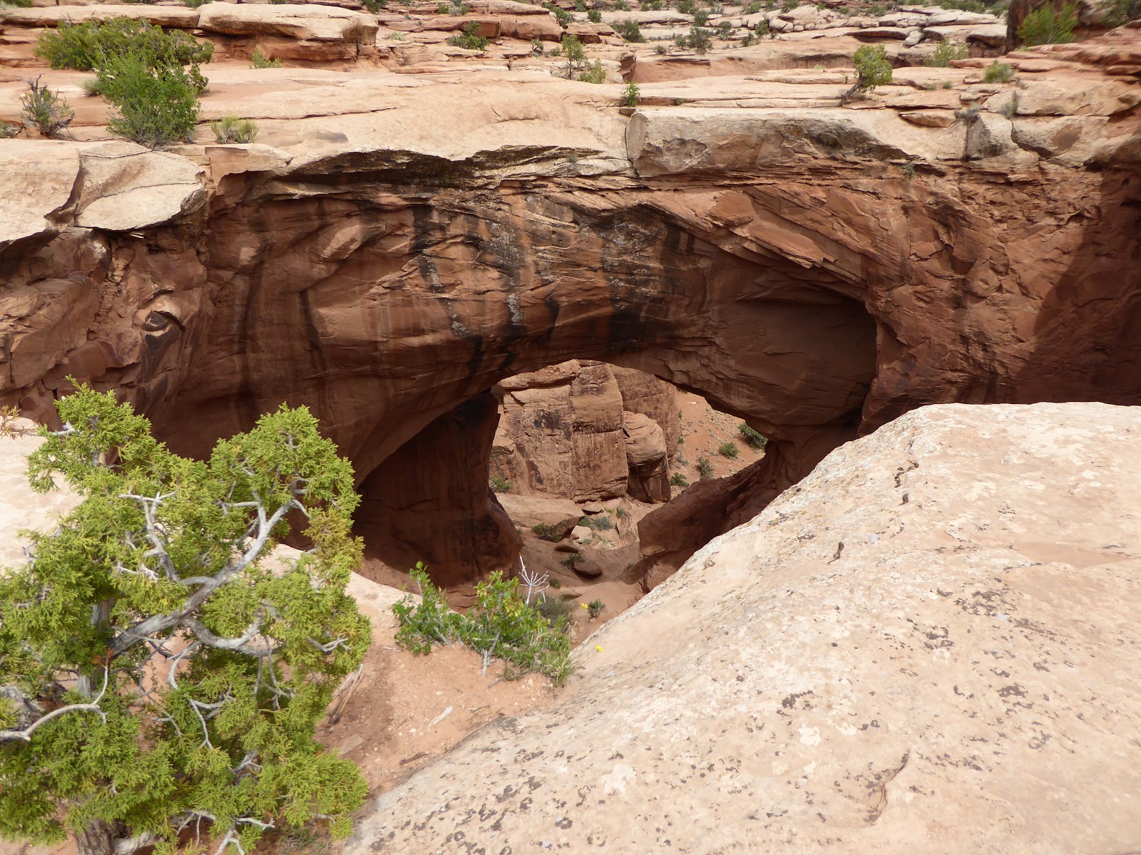
There are a ton of MTB trails out there - most above my pay grade, I suspect - so there is a lot of activity; I would imagine that this area is a circus on the weekends.  We stopped for a quick walk out to the Gemini Bridges (two thick natural bridges right next to each other), before continuing on the road which spit us back out onto 313.

Long Canyon: also twisty

We still had time so we thought we'd give the Willow Springs Road a shot.  We hadn't asked Nick at Twisted Jeeps about it but we'd driven a chunk of it before, coming in from the Arches National Park road, and it had been easy, if sandy, driving.  This time we were coming at it from the other side, driving out to the Klonzo MTB trails and then continuing on into the national park.  You don't have to pay when you sneak in the back way.

One of the Gemini Bridges


When we had crossed the park boundary, we started driving over a slickrock section that presented us with the most technical driving we'd had all day.  H really enjoyed this part, stopping to get out and scout the best route, then hopping back in to inch forward to the next scouting spot.  We weren't making very good time, however, and before long we realized that we'd need to return the jeep.  We turned back before making all the way through - there's another road we'll need to explore further.

H, near Gemini Bridges


We dropped off the jeep, every surface of which was covered in fine, red dust (as were we), but that is part of the rental agreement.  (If you bring it back muddy, you have to wash it first, however.)  The guys did the most cursory review of the jeep before sending us on our way.  Couldn't have been easier.

Willow Springs Road(-ish)


As dirty, dusty and windblown as we were, we were also jazzed about our day and stopped off at Woody's Tavern to debrief over beers.  Back at the motel, we hung out with Pearl and Mei-Mei, the motel office dogs, and chatted with Katie the owner.  It may have slowed our clean-up process but after 13+ stays at the Kokopelli Lodge, it's nice to have made a connection.

Straight up = Shafer Trail
Straight down = Long Canyon
Peaked up = Gemini Bridges

Dinner that night was a return to 98 Center, with basically the same food selections as before, with slight adjustments (two orders of steamed buns, no noodle salad).  After that, it was just cocktails in front of our room and conversations with other motel guests as the stars came out.  An immensely satisfying day, we thought.


Wednesday, May 16, 2018

the elusive hunter canyon rim trail

Sunday didn't go quite as planned but we did manage to enjoy it all the same.  My plan was for us to do a long loop (which, to be honest, in hindsight was perhaps a little ambitious) of the Hunter Canyon Rim trail to Pritchett Canyon, knocking off a couple of arches and putting about twelve miles on our legs.  That was the plan, anyway.

Heading down the Cliffhanger (that's not us)

We headed out Kane Creek Boulevard until it turned to dirt, parking in the large staging lot there.  This is a popular road for MTBers heading to the Amasa Back trail system and for off-roaders heading out Kane Creek to parts further afield.  We started walking down the Kane Creek dirt road, past the rapidly-filling Amasa Back trailhead.  Before we got too far, we stopped to watch MTBers - much, much more skilled than I - heading out and jeeps picking their way down the Cliffhanger trail.

And that's why it's called the Birthing Panel

As the road climbed, we stopped again at the Birthing Panel, a roadside boulder covered with pictographs.  Despite the increasing jeep traffic, it was a nice walk on that dirt road, scenic with switchbacks and beaver-felled cottonwoods as we made our way down past a natural spring.  We did notice a trail heading up a side canyon there but since I hadn't yet found that gjhikes.com trail link up there in the first paragraph (not until after the fact), we kept going to the Hunter Canyon campground (which had lovely sites but the busy Kane Creek road running right through the middle), at the mouth of pretty Hunter Canyon.  Once there we rechecked our map - oops! - and retraced our steps back to the trail by the spring.  It wasn't too far, luckily.

Looking across Kane Creek to the MTB trails

The trail went up Gatherer Canyon and for the first little bit, we were able to follow it.  Gatherer Canyon is a small box canyon that ends in a pour-off, ledges and cliffs.  We made our way up several levels of ledges and then we just lost the trail.  We spent a fair amount of time working our way back and forth but just could not figure out where to go: we got stuck on a ledge that we weren't sure we could get up and, once up, we definitely weren't sure we could get back down.  So we cut our losses and went out.  At first we thought that maybe we were still in the wrong canyon but then we found MTB tracks - although we had no idea how they got in there.

Switchbacks down to creek level

A little frustrated, we headed back on the dirt road, stopping to go up a side canyon across from the Amasa Back trailhead, and pausing to watch rock climbers scaling the 1,000 foot red rock walls.  At the trailhead, we once again checked the map: we had been in the right canyon, we just couldn't figure out the route.  Hike stats:  8.03 miles.

Water just gushing out of this spring

We made a quick stop back at the room for supplies, swung by Twisted Jeep Rentals to arrange for a jeep for Monday (quoted $245 for an all-day rental), and then drove out Mineral Bottom Road for beers under some delightfully twisted juniper trees.  We had passed some cows on the way in but other than a couple of jeeps passing by on the main road, we had the place to ourselves.  We used the time to look over the probable jeep route for the next day, as well as quite a bit of bird watching.

Snack break

That evening, after getting cleaned up, dinner was a veggie pizza at the Zax bar.  The day hadn't gone as planned but we managed decent mileage and spent most of the daylight hours outside in the southern Utah desert, which is pretty ideal even if you can't find the trail you want.

Dude.  I would never.

Sunday, May 13, 2018

up on the mesa

Saturday morning we were up and out of the room by 7 a.m., with plenty of time for a Dead Horse Point State Park parking lot breakfast of PB&Js before getting on the MTB trails at 8:15 a.m.  At that hour, we had the place pretty much to ourselves.  It was a gorgeous morning, clear and sunny, with cool temperatures.  It had rained a few days before, which left the dirt trails nicely packed and a few puddles remaining in the desert potholes.

The view from DHPSP never disappoints

We did the Big Chief trail on the Intrepid (east) side of the park, then went across the park road (on the Crossroads trail - cleverly named) to the newer trails on the west side.  Out there, the trails were packing down nicely - they had been so sandy when they opened in 2014.  We went out and back on Whiptail and did Twisted Tree to add a little lollipop loop.  Although I have to walk a fair bit of Twisted Tree, we both felt like we were riding pretty well.

Hell Roaring Canyon

Not having to dodge other riders certainly makes MTBing more fun.  We saw a lone hiker on the Intrepid side and encountered only five riders (a family of four and a single guy) on our way back from the west side.  We didn't even come across any riders heading out as we finished up, and that's usually where you get pushed off the trail by newbies and little kids.  The parking lot was packed with tourists, MTBers and hikers when we got back to the truck and we couldn't believe we had been so lucky out on the trails.  Ride stats: 16.38 miles; just under 2 hours; average speed: 8.5 m.p.h.; max speed: 17.7 m.p.h.

Looking for a way down

After a quick sandwich to refuel, we drove out of the park and north on 313, as though we were going back to town.  At the sign for the Lone Mesa Campground, however, we turned left on the dirt Dubinky Wells road. We were looking for a "trail" to the Comet Thrower, a pictograph site in Hell Roaring Canyon that I'd learned about by poking around on hiking blogs.  Since we've hiked most of the official trails in Arches and Canyonlands NPs, we've been trying to explore further afield.

This is the place

We left the Dubinky Wells road, veering off on the Spring Canyon road, passing numerous primitive BLM camping areas.  At about six miles in, we crossed the Dubinky Wash and parked at an empty campsite.  After wandering around the slickrock for a while at the rim of Hell Roaring Canyon, with no one but jack rabbits, birds and lizards for company, and utilizing our GPS, we finally found the so-called trailhead (coordinates for the drop-point are N 38 37.681 W 109 53.759). 

Over the edge and to looker's left

While we were thrilled to have found the point we were looking for, we were less thrilled with what we actually found: barbed wire wrapped around iron bars drilled into the rock ledge, and very loose footing down the scree on the cliff face.  We debated it for a while, making note of the time of day, how much water we were carrying and the potential distance ahead of us (10+ miles round trip). 

Mind the barbed wire, though

In the end, we nixed descending into the canyon and instead went back to the truck (identifying some truly excellent campsites for future reference) and instead had beers in the shade of a juniper tree, with the spectacular desert scenery spread out in front of us.  Can't say that was a bad decision.  Hike stats: just under 3 mi., about 2 hours of walking around.  It does look like a good hike, however, and now that we know where it is, perhaps we'll go back earlier in the day and try it again.

The desert is so beautiful

When we got back to Moab, it was much warmer in town than it had been up on the mesa.  We got cleaned up, went to dinner at 98 Center (steamed buns, cold noodle salad, pho and bahn mi, with one of the best local spring greens salads I've ever had).  Afterwards, it was a lovely evening for sitting outside our room with drinks, chatting with our motel neighbors and making plans for the next day.

Friday, May 11, 2018

first stop: sego canyon

It's spring!  That means we get to go to Moab!  And off we went, leaving the house at 5:30 a.m. Friday morning.  We tried a couple of times to get ice on our way out of town, finally managing to score some in Spanish Fork.  It got cold as we drove through Spanish Fork Canyon - down to a very brisk 24F! - then warmed up as we continued to drive south and east.

Ute Historic panel

We passed the Moab exit off I-70 and continued one further to the tiny (2010 census: population 39) town of Thompson Springs.  There are only a handful of houses and an abandoned (but awesome-looking) motel, currently for sale for $225,000 if anyone is interested, but little Thompson used to be hopping.  Back in 1910, a rancher found coal up in Sego Canyon, cannily bought the property and proceeded to build up a coal mining operation, complete with a small town.  The Denver & Rio Grande railroad ran a line up the canyon to bring the coal down to Thompson, from which it was shipped all over.  The water started drying up by 1915, however, and production ceased for good in 1955.  Most of the houses were brought down out of Sego Canyon and taken to Thompson, Moab or Fruita.  Now, all that is left is a ghost town and some wonderful native rock art.

Barrier Style

It was cool and sunny when we parked in the lot for the rock art.  There are both petroglyphs (drawings carved into the rock) and the rarer pictographs (painted onto the rocks) in the three main panels: the Ute Historic Panel, likely from the 19th century, white pictographs with red detailing; the Fremont Style Panel, with men, bighorn sheep and geometric designs; and the impressive Barrier Style Panel, with life-size, alien-looking figures.

Seriously alien-looking dudes

There are a couple more panels across the road, behind a cattle corral.  Those pictograph figures there were huge - the biggest I've ever seen.


Continuing up the road, we made our way to the ghost town, first stopping at Boot Hill Cemetery.  This is a small cemetery, where people have placed coins on every single grave.  Like, lots of coins.  There is also one grave in the southwest corner for a man who served in the Vietnam War: it has two headstones, one ornamented with a Christian cross and one with a Star of David.  Maybe he converted?

Boot Hill Cemetery

Up at the ghost town, there are several roofless buildings dug into the hillside.  The stone company store, roofless as well, dominates the landscape, the calls of the resident canyon wrens echoing off its walls.  There is a collapsed wooden building - likely the boarding house - surrounded by cottonwood trees, and the road continues on, up to the actual mine.  We poked around for a while, imagining what the place would have been like with 500 townspeople, then continued on our way.

Sego ruins

On our way into Moab, we stopped at the Moab Brand Trails to do our two loops of Rusty Spur/Bar M.  We shortened it a little bit, finding our way back on a much pleasanter double-track instead of the gravel road.  Ride stats: 16.73 miles; 1 hr. 34 minutes; avg. speed 10.6 m.p.h.; H's max. speed 23.1 m.p.h.

Interior of the company store

After that, we checked in at the Kokopelli Lodge and were greeted by resident dogs Pearl and Mei-Mei (sadly, one of our favorites, Frank, had been killed by some other dogs last fall).  We cleaned up, worked on a plan for the next day and walked ourselves down to dinner at the Moab Brewery.  Even though it was a Friday night, we got seats at the bar immediately - always a plus.  We also bought a bottle of the new Moab Distillery's Spot On Gin to take home with us - always a plus.