Showing posts with label Bryce Canyon National Park. Show all posts

Wednesday, August 15, 2018

under the rim trail (a/k/a the big hike) part 2

We were still at the edge of the burn zone but coming out of it and climbing regularly; closer to the cliff walls we had to go up and over, crossing from one dry drainage to the next.  We were catching some breezes up at each crest but the ascents were hot; although the forecast for the park had been 83F, it was closer to 90F down under the rim.

Six hours in

With these temperatures hotter than we expected (or hoped), the heat began to take its toll.  We were fine for water but the heat made us disinclined to eat and our empty stomachs soon became upset stomachs.  At hour 7, 15.31 miles in, we decided to stop for thirty minutes, to sit in the shade and try to eat a little.  After that, the plan was to stop every half hour for five minutes, in whatever shade we could find.  This helped, for sure, although we still didn't feel like eating.

Still enjoying the views, despite the heat

At this point, there was no way we were backtracking to the Sheep Creek connector to bail out.  Hour 8/16.81 miles came and went.  At 2:13 p.m., we passed the Yellow Creek campsite (17.41 miles) and saw six campers hanging out.  They had obviously come down from the Bryce Point side, an easy 5.5 mile downhill walk. Although the tiny creek was flowing, the park service had posted signs warning people to boil any creek water as there had been reports of E. coli (!!).  We kept walking, drinking down our own water, warm but uncontaminated.

That just looks hot, doesn't it?

We then left the drainage, walking through a very hot and dry sagebrush section as we rounded the end of the bluff, then started up the final drainage that would take us to Bryce Point.  For some time we were walking in the shade of big trees, on well-packed dirt, and we felt pretty good.

Coming around the end before heading up the final drainage

The last couple of miles - whew!  Those were rough.  We left the shade of the trees and started climbing in earnest.  The trail was totally exposed, although since we were nearing civilization, it was broad and smooth, easy walking if you haven't already done 21 miles.

The Hat Shop (I think, or in the vicinity)

As we got higher, the scenery got dramatic once again; we crossed a gorgeous ridge (the Hat Shop) and continued up the switchbacks, ever nearing the rim.  At about 10 hours and 20.99 miles, we passed three hikers - clean and fresh in brand-new clothes - who were exploring this end of the UtR trail and kept going, up up up.

Just got to get there now

By now, H was just focused on walking, one foot in front of the other, ignoring the blisters that had built up under his toes.  I was struggling a lot, feeling lightheaded and sick to my stomach, having to stop and lean over my hiking poles on every switchback corner.  At one point I shouted "HEY!" to H, who was up ahead a little ways; when he turned to look, I gave him the "time out" sign and then just sat down, right where I was on the trail.  After about five minutes (when no one magically appeared to rescue me), during which time I forced down half a granola bar, I got back up and continued trudging upwards.
Ten hours in/five minute rest

Then, wonderfully, we saw it: a car driving past on its way up to the Bryce Point overlook.  I hadn't realized how close we were since the UtR23 trail comes up on the far side of the ridge; we never even saw the amphitheater.  With the end clearly in sight, we got a last surge of energy and finished in (relatively) good form.  We did not, however, pause our steps to let the tourists take their photos - at that point, we weren't stopping for anything.

I don't look like I'm about to fall over

Once at the top, (4:55 p.m.) I could have kissed the Bryce Point sign.  Instead, we high-fived, got a tourist to take our picture and collapsed gratefully onto the bus seats when the shuttle arrived five minutes later.  We had done it!  We were psyched.  We were tired.

Views for days

We didn't even mind that the shuttle had to make numerous stops before dropping us back at our campground because that meant we got to stay sitting down longer.  When we did get back to our cabin, the first thing we did was pound the Gatorades that we had waiting for us in the cooler.  That brought us back somewhat; showers rejuvenated us further; and then dinner at the Ruby's Inn Cowboy Buffet (unlimited soup and salad bar) helped even more.  Even so, I was asleep before the sun fully went down, although H managed to stay up long enough for some star-gazing.
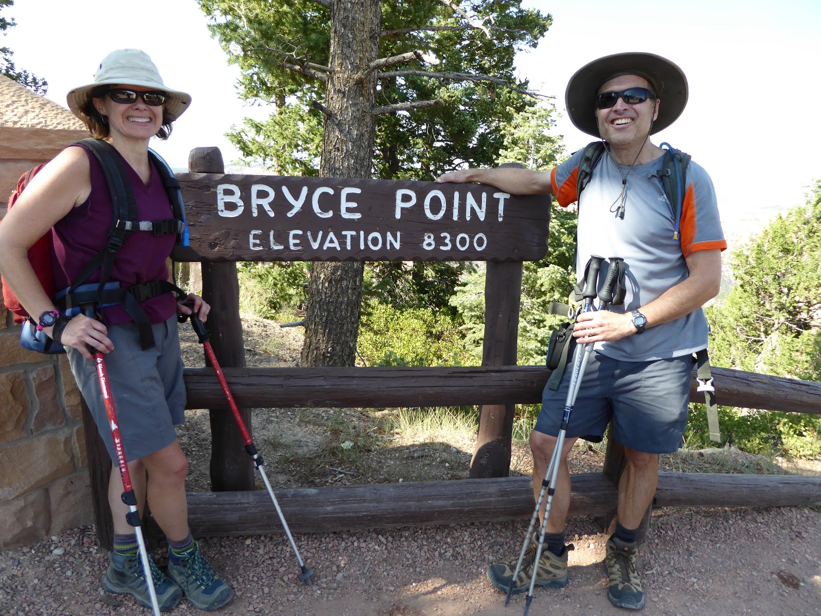
WE DID IT!!!

The more time went by, the more we appreciated the hike.  (And I especially appreciated the fact that the next morning, H rode his bike all the way back, uphill, to Rainbow Point to collect the truck: when he stopped at the park entrance to explain that the park pass was in the truck and that he was riding back to get it, the ranger raised an eyebrow and just said, "Huh.  That's a long ride." and let him go through.)

Post-hike feet - no blisters!

Once the fatigue dissipated, we ended up in good shape: our backs were a little stiff and H had a couple of blisters (I, amazingly, had none) but we were feeling pretty good.  It's safe to say that we will never do the UtR23 in one day again - perhaps as a two-day overnight camping trip - but we set a goal, trained for and achieved that goal.  And that feels great.

Uphill finishes are always fun

Hike stats: 23 miles with 4,320 feet of elevation; total time 11 hours 5 minutes with 8:18 of hiking and 2:49 of stoppage (even with the extra resting, we finished ahead of what H's initial plan had been: 11 hrs. 24 min.) ; moving average speed 2.7 m.p.h. and overall average speed 2.0 m.p.h.


Couple of different versions of the map


Monday, August 13, 2018

under the rim trail (a/k/a the big hike) part 1

You know how we've been doing long hikes all summer?  It's all been leading up to this, the Big Hike, doing the entire 23 mile Under the Rim trail in one day.  When we were at Bryce last fall with H's parents, we learned about the little-frequented UtR23 - running from Bryce Point to Rainbow Point, all under the rim - and then, after a little research, we learned that while most people do the UtR23 in two or three days as overnight backpacking trips, a few people do it all in one day.  H and I decided that we would be a couple of those people.  The 136 hiking miles we'd done since May were all training.

At the start (with sunglasses because I blink at the flash)

The vast majority of visitors to Bryce stay within the amphitheater area (Sunrise Point, Sunset Point, Inspiration Point and Bryce Point), many staying up on the paved Rim Trail and peering at the scenery from the viewpoints.  Quite a lot venture down into the amphitheater via the short Navajo Loop Trail; some slightly hardier souls will take the Peekaboo Loop Trail from Bryce Point.  A fair number will take their own cars all the way out the 18-mile scenic drive to Rainbow Point, stopping at the overlooks on their way back.  A few will venture out on some of the shorter hiking trails, like the Swamp Canyon/Sheep Creek loop, but Bryce is not a user-friendly park for novice hikers.

One of many blow-downs

Only a handful will attempt the UtR23, due to its length, wilderness status and lack of water.  There are several backcountry campsites along the trail but permits are required.  I had emailed the park, asking if permits were needed for folks attempting to do it in one day.  The answer is no, and you can leave your car overnight at the trailhead, but you'd best be prepared to carry all your water because the few water sources are unreliable.  Thus informed, we were determined to do it although I was really worried about blisters, especially after how beaten up our feet were after the 18-mile hike we'd done in Park City.

HOUR 1

Sun finally hitting the cliffs

We carefully prepared our packs, paring down the weight as best we could since I would be carrying 5L of water and H would be carrying 6L (and water is heavy).  We also mused at length about what food to bring, realizing that we'd need stuff that was packable but not heavy, and that would pack a punch energy-wise but would hopefully sit well in our stomachs.  We ended up with granola bars, KIND apricot and almond bars, sour gummi bears, jerky, honey waffles and a couple different kinds of energy gels.  It seemed heavy on the sweet stuff but we thought it would get us through.  We even managed to think a little about recovery and had some Gatorades sitting in the cooler with the beer.

Crossing a dry creekbed

Monday morning we got up very early, dressed quickly (having laid out everything the night before) and were in the truck at 4:45 a.m.  We got to Rainbow Point around 5:20 ... and then had to wait around for the sun to come up a little so we could see the trail.  There were two other cars already in the parking lot, ostensibly backpackers who had overnighted in the backcountry.

Looking back from whence we came

Pretty glade

By 5:50 we could see enough to start, descending quickly from Rainbow Point.  We had read that there were a lot of blown-down trees across the UtR23 earlier this year.  There were still a lot of blown-down trees across the trail and we had to carefully pick our way across them.  After the first hour of hiking, we had done 2.39 miles and were feeling good.  The air was cool, the rising sun coloring the cliffs under the rim a warm and glowing pink.

Coming up through a burn zone

The funny thing about doing the UtR23 is that, for the most part, you are in the scenery so you don't see quite as much of the scenery which is visible from the rim.  We would follow along at the base of the cliffs for the most part, often in trees, sometimes in meadows, sometimes switchbacking over a rise.  The first landmark per se came at 7:19 a.m., mile 3.56, when we passed the Iron Springs backcountry campsite.  We continued the up and down, scrambling over fallen trees, and at two hours in had ticked off 4.83 miles.  At 8:27 a.m./6.04 miles we had just finished a short climb and passed the currently-closed (for "major trail damage")  Agua Canyon connector trail and at the three hour mark we had put 6.97 miles behind us.

Descending from the Swamp Canyon campsite

We were just under four hours in (and at 7.42 miles) when we saw our first people: two French backpackers who were just putting away their tent after an overnight at the Natural Bridge campsite.  We said good morning, continued on our way and never saw them again.  The trail was pretty pleasant underfoot, a little rocky in spots, a little washed out in others, but often level dirt, the kind of hero surface that makes you think you can walk forever.

Mud Canyon

Mud Canyon the other way

At about 10:30 a.m., we passed the Whiteman connecting trail (the trailhead on the park's scenic drive offers "backcountry parking") and the Swamp Canyon campsite.  We had just entered a large burned area, walking through what is now a meadow with scorched Ponderosa pine trunks.  This was the only one of the backcountry campsites we saw that really had a view: it was located at the crest of a rise and looked out over the spectacular Mud Canyon (terrible name!).  There is no water at the actual campsite but when we continued on the UtR23, we did find a small spring at the bottom of the hill.

HOUR 5

Five hours into the hike, we were approaching the halfway point, having ticked off 11.18 miles.  We also found ourselves on the bit of the UtR23 that we had done on our little hike the day before - familiar territory!  In rapid succession, we passed the Swamp Canyon connector trail (12.14 miles/11:14 a.m.), the Right Fork Swamp Canyon campsite (12.19 miles/11:16 a.m.) and the Sheep Creek connector/campsite (13.30 miles/11:40 a.m).

The way ahead

Now we were past the halfway point in mileage.  Now we were committed, because the Sheep Creek connector was the last chance to bail out - there are no other exit trails until the end at Bryce Point.  Now it was starting to get hot.

To Bryce Point: 9.5 miles
To Rainbow Point: 13.1 miles
Onwards!

To be continued ...

Saturday, August 11, 2018

moving up-country

On Sunday morning, we didn't get up until 7:30 a.m. and were pretty much the last ones out of the motel parking lot at 8.  We drove up to Bryce Canyon National Park, through scenic Red Canyon which had suffered massive washouts the week before when the area received 1-1.25" of rain in 45 minutes.  There were huge mounds of rock and gravel on the shoulders that had been cleared off the road; the hillside to the east was carved into deep channels from the run-off; and some of the bike path had simply been washed away.


At the entrance to the park, we paid for our annual pass, poked around for a few minutes at the visitors' center and then headed out on the scenic drive for the Swamp Canyon trailhead.  We decided to do the Swamp Canyon/Sheep Creek loop clockwise, starting out on the Sheep Creek connecting trail.  The trail passes through grassy meadows before descending below the rim to meet the aptly-named Under the Rim trail (which we would be doing the next day - stay tuned!).

Trailhead

We turned right and went south on the Under the Rim trail for about 1.1 miles (between the Sheep Creek backcountry campsite and the Right Fork Swamp Canyon backcountry campsite), then turned right again onto the Swamp Canyon connecting trail.  This section of the trail was dirt and sand and fairly level and we hoped it boded well for the next day.

Pretty meadow start

The Swamp Canyon connecting trail climbed steadily, passing by a bubbling spring and through nice stands of pines.  It brought us back up to where we started, making a nice loop to stretch our legs.  Hike stats:  4.56 miles; 1:34 hiking time / 1:48 total time; 2.9 m.p.h. moving average speed / 2.5 overall avg.; 810 feet of climbing.

Big burned-out tree trunk

After a post-hike beer, we drove out to the end of the scenic drive at Rainbow Point, hoping to find a place for lunch.  The parking lot was full, though, so we headed back out to Fairview Point, where a downed log with a view made for a good, informal picnic spot.  Despite the busyness at Rainbow, there was hardly anyone around: we had only seen a couple people during our hike (during prime hiking time of 10 a.m. - 12 noon) and the other overlooks weren't that crowded either.  No complaints - especially when I later heard that Zion National Park was slammed this weekend.

Green trees, blue skies and pale cliffs

We checked in at Ruby's Inn RV Park and Campground where I had reserved a little cabin (#4 (note: #2 is less sun-baked in the afternoons)) for the next two nights.  This kind of place really isn't our scene but because of our hiking plans, I wanted to be close to the park and we wanted a secure place to keep our bikes.  The cabin was perfect: tiny, with a table, benches, double-bed bunks, electricity and a front porch.  There are also over 200 RV sites, numerous tent sites and some teepees available for rent; your rate includes showers (no coin op!) and running water in the bathrooms; there is a laundromat and small swimming pool on site; and while there aren't any restaurants right in the campground, Ruby's Inn has several dining options within walking distance.  There's also free BCNP shuttle stop right at the entrance.  For those tourists who don't spend a lot of time in the outdoors, this introduction to camping must be a delight.  For us, it suited our purposes.

Just right!

The rest of the afternoon and evening was spent getting settled.  We laid out our clothes for the next day's hike and packed our packs, all the while working on getting hydrated by alternating 12 oz. beers with 12 oz. of water.  Dinner was rice and beans on the campstove, eaten on the little porch as the sun started to set.  As the sky darkened, the stars began to come out, as did a number of little bats, snacking on the insects swarming over a nearby pond.  Despite the robust human population in the area, it wasn't too noisy and we were able to go to bed early.  Big day on the morrow.

H's pack prep


Thursday, August 9, 2018

escape to bryce canyon national park

H and I got back last Tuesday from a long weekend down at Bryce Canyon National Park.  It was great to get back there - and we hope to have posts with lots of photos up for you soon, although we are currently dealing with some technical issues that are holding things up.

Image result for purple sage motel

We headed south Saturday morning, just after 10 a.m. (allowing H to mow the lawn before we left), and took the scenic route down, hoping to limit our time on the interstate.  We got off I-15 at Spanish Fork - which gave our GPS unit fits - and followed US-89 through the San Pete Valley, cruising through tiny, central Utah towns like Fairview, Gunnison and Manti.  That area is both agricultural in the valley and an ATV mecca in the surrounding mountains.  We got to Panguitch around 2:30 p.m. and managed an early check-in at our old friend, the Purple Sage Motel.  We got Room #1, which was great, nearly twice the size of the room we got when we were there last.  We took our time getting repacked and reorganized, and going over hiking plans for the next couple of days, then walked the half mile to C-Stop Pizza for truly excellent veggie pizza (roasted tomatoes!).  They don't have a liquor license but we had a cooler full of beer back at the room, just a short walk away.

Wednesday, September 27, 2017

road tripping: day 2

In the morning, H went for a run under a gorgeous pink and orange sunrise before we all had a tailgate breakfast of fruit and bagels, accompanied by pretty good coffee from the motel's breakfast room.  We got ourselves organized and were on the road back to Bryce by 8:15 a.m.  Once at the park, we checked out the awesome views at Sunrise Point and recycled a used propane cylinder (Bryce seems to be the only Utah national park that collects those cylinders for recycling).

The Amphitheater in the morning

We then headed out, stopping at Kodachrome State Park, and then continuing along scenic Route 12 through Henrieville.  H and I had only traveled short pieces of Route 12 before - from Bryce to Kodachrome; and then on the other end from Torrey up to our campsite at Single Tree - so this portion of the road trip was new to us.  Scenic Byway 12 is said to be one of the most gorgeous roads in the country and I can believe it.  We followed the river for a while, past high, pale cliffs, and stopped to check out a Native American granary high in the rock above us.

H's folks

The road passes through the funky little town of Escalante (population around 800, with the Shooting Star RV Resort, where you can rent vintage Airstreams, and a wonderful visitors' center).  After Escalante, we came around a corner and the vistas just opened opened up in front of us.  We could see forever, it seemed, and we could also see our road twisting and turning below us, winding in and out of the colorful rock formations.  We continued down past those rock walls and then up and over the Hogsback - a high and very narrow stretch where there were impressive drop-offs on both sides, and no guardrails - before descending into little Boulder (population: approximately 200).

Road trip!

Ancient granaries

We paused for a snack on the picnic tables in front of the Anasazi State Park Museum, then kept going, up and over Boulder Mountain.  For a while, our surroundings were green and forested, and we passed by our former campground, then it turned back to red desert as we descended to Torrey and Capitol Reef National Park.  Capitol Reef is more of a hikers' park as most of the park is only accessible on foot or rough 4WD roads.  To enable H's folks to see as much as possible, we did the paved part of the scenic drive, stopping at the picnic area under the red cliffs when the road changed to dirt to continue through Capitol Gorge.

Scenic Byway 12

After retracing the route through the desert and then the old Mormon pioneer-planted orchards, we returned to Torrey, checked into our motel and then figured out what to do for dinner.  We checked out a couple places before deciding on Red Cliff Pizza (yes, pizza for two nights in a row) at Red Cliffs Pizza which a work friend had recommended.  As we filled our bellies, the restaurant filled up around us with both tourists and local cowboys.  When we were done, we headed back to the room for an evening in.

Scenic Capitol Reef

Saturday, September 23, 2017

road tripping: day 1

As I mentioned, H's parents came for a visit recently.  Usually when they come, they only stay for three or four days; this time, H convinced them to stay long enough for a road trip.  H's mom had mentioned that she wanted to see Bryce Canyon National Park and we figured that we could put together a quick loop that included Cedar Breaks National Monument and Capitol Reef National Park as well.

The Cedar Break Amphitheater

H and me at Cedar Breaks National Monument

To facilitate scenery viewing and ease of toting people and luggage, we rented a minivan, picking it up at 7:30 Monday morning and heading south on I-15 by 8.  Once we got past Provo, the traffic thinned out and it was smooth sailing all the way to Cedar City.  We drove up the scenic road to Cedar Breaks National Monument, arriving midday.  It was much nicer weather than when H and I had been there last, clear and cool this time up at an altitude of 10,350 feet above sea level.  The monument's amphitheater glowed a soft orange, pink and white under the sun.

H and his folks at Bryce Canyon National Park

We continued down Route 143 to Panguitch, then turned before hitting town (no sense in getting to Panguitch too soon) and going straight up to Bryce Canyon National Park.  It was clear and breezy, warm in the sun but cool in the shade.  For a late September Monday, it seemed pretty busy and as we headed out the scenic drive towards Rainbow Point, we were a little worried about finding parking.

Along the BCNP scenic drive

The crowds weren't really a problem, however, as we were able to stop at nearly every overlook as we worked our way back.  The only places we couldn't get into were Bryce Point and Sunrise Point where there were "PARKING FULL" signs and park rangers turning cars away.  Figuring we'd come back in the morning for Sunrise Point, we opted for beers and snacks at the Fairyland trail head to finish the afternoon.  Fairyland is great: since it is technically outside the park gates, it doesn't get nearly as many people and we had the picnic table all to ourselves.

The Amphitheater at BCNP

Even though H and I had done that scenic drive when we were at Bryce before, it was totally different this time: last time it was raining and cloudy and we couldn't see anything our first day.  This time, there were no clouds at all and the views stretched on forever.

An arch at BCNP

We drove back to Panguitch and checked in at the Adobe Sands Motel.  This is another tiny independent motel, one of about a dozen that line the town's main street.  The Adobe Sands was not fancy, big or particularly modern but the kid checking us in was super-friendly, the rooms were clean and the bed was much more comfortable than it looked.  (And in the morning, we would discover that the showers were very hot.)

Fairyland TH picnic

We had beers outside the room then went in search of dinner.  Dining options in Panguitch are still limited and our first choice, the Cowboy Smokehouse, continues to be closed on Mondays.  So we ended up a few blocks out of town at the C-Stop for "artisan" pizza.  The place was packed but the frazzled (but still very nice) waitress said we could sit at the tables outside if we didn't want to wait.  It was still pretty warm so that's what we did, patting puppies and talking with hippies until our very good pizza arrived.

The whole room, not including bathroom

After dinner it was back to the motel for a couple more beers out front as the stars came out.  Despite our being in town, Panguitch is small enough that there wasn't much light pollution.  We could see the Milky Way glittering above us and it was beautiful.

Awesome motel sign