Friday, October 30, 2015

winding up, we hope

I went back east to see family for a week after our southern Utah sojourn.  I got back Saturday evening and when Sunday morning rolled around, we thought a MTB ride would be good to shake the cross-country travel cobwebs out.  We waited a while for it to warm up a bit in Park City; while the sun never broke through the high clouds, it ended up being a comfortable temperature to ride.  I wore my arm warmers and my long-fingered gloves while H took his arm warmers with him but never put them on.  We warmed up nicely on the climbs and only got slightly chilled when we paused  in the wind at the top of hills.

It's definitely fall here now, despite the slightly warmer than usual temperatures, with most of the leaves off the trees and the wind being stronger than it's been all summer.  It's also definitely fall in that there are very few people out on the trails, either on foot or on two wheels.  Personally, I like riding this time of year: it's cooler and with fewer leaves on the scrub oaks, it's easier to see if anyone is coming at you on the trails.  Trail work has also stepped up a bit, including a re-routing of our regular ride.  The climb that we called "My Nemesis" has been closed for re-vegetation and a new trail has been installed in its place.  It still takes you to the top of the same hill that My Nemesis did but instead of a straight slog up, there are several switchbacks, making the climbing easier but longer.

At the bottom of what used
to be My Nemesis

I was not riding my best for some reason, feeling very wobbly on the rockier spots and whenever I was going very slowly.  I even tipped over into a sagebrush bush on an uphill switchback to the right on the Nouvelle Loop, one that I've ridden dozens of times, simply because I was going just too slowly.  At other times I did pretty well, however, climbing the Sweet Sixteen switchbacks just less than two minutes slower than H, and climbing the Staircase as well as I ever have.  My legs were well-rested, at least, and my lungs weren't suffering from a week at sea level.

Updated Round Valley route map

We are actually hopeful that this will have been the last MTB of the season: it's practically November and in theory the weather will turn too cold and wet and snowy for any more rides.  It's been a good MTB season.  Now it's time to turn to something else.  Fingers crossed!

Wednesday, October 28, 2015

all good things

With slightly heavy hearts, we packed up our things on our last morning in Moab, saying farewell to the quirky Kokopelli (until the next time).  We had hoped for a return engagement at Wake & Bake for breakfast but it was inexplicably closed, so we ended up at the Moab Diner again.

A still moment down by the Colorado River

A drive out the Potash Road to the boat launch on the Colorado River seemed to be in order; the river was calm and quiet and much, much lower than it had been in May.  Temperatures were just about perfect (low 70s) and the skies were perfectly clear - possibly the very best weather we've ever had in all our trips to Moab.

Always happy on these trails

We stopped again at the MOAB Brand Trails on our way out of town to do two more circuits of Rusty Spur and the Bar M loop.  I wasn't riding quite as well as I had been a few days earlier; cumulative fatigue had definitely set into my legs and I had to muscle my MTB up a couple of spots that I had ridden with ease before.

One last dead tree art shot before we go

Our last stop before heading home was Ray's Tavern in Green River for their wonderful burgers and hand-cut fries.  We always like going to Ray's but it's always a little bittersweet because it means vacation is over.  Luckily, the drive north flew by (for me, anyway) as I read aloud the trail descriptions of over forty Moab area day hikes from our newly purchased hiking books.  We've already got some in mind for the next time we head to southern Utah.

Monday, October 26, 2015

new trails in arches

We didn't have to get up at the crack of early on Sunday since our Fiery Furnace guided hike didn't start until 10 a.m., instead sleeping in a bit, then having breakfast at Wake & Bake before swinging by the store for sandwich/beer/ice supplies.  We drove into the Fiery Furnace parking lot at Arches National Park with plenty of time to spare, despite having to wait in line at the park entrance.  Arches is an incredibly popular park and the stunning weather was encouraging folks to get out and about early.

Within the Fiery Furnace

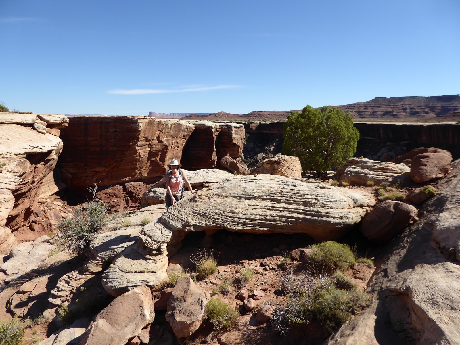
We had about twenty-five people in our group, with an age range of mid 20s to early 70s and an experience range of us (feeling cocky with Gooseberry under our belts) to "practically never having stepped off a sidewalk."  The ranger who led the hike, Alison Van Lonkhuyzen (sp?), did an amazing job of keeping the group together, safe, informed and engaged during our 2 mile, 2.5 hour tour of the Fiery Furnace.  She was great at reading our group, in addition to engaging with the other permitted groups exploring the area.  She conveyed a ton of information about Arches in general, and the Fiery Furnace specifically, as well as her affection for the greater Moab area.

Skull Arch (the skull is upside down)

We were in the guided hike in the first place because the Fiery Furnace is a delicate and restricted area.  You are only allowed in with a guide or, if unguided, with a permit (and they vet you carefully before handing out those limited permits).  There are no actual trails within this area and the ecosystem is quite fragile, including one plant, the Canyonlands biscuitroot, which is only found there and one other place on the planet. 

Me, bringing up the end of the group

It's a pretty spot, although we have seen places equally as scenic in our own explorations, and people want to get in there - but it is important to protect it and I think the Park Service is doing the right thing in limiting the foot traffic.  Going on a guided hike isn't really our kind of thing but we were glad to have finally been able to do it.

Surprise arch, somewhere in there

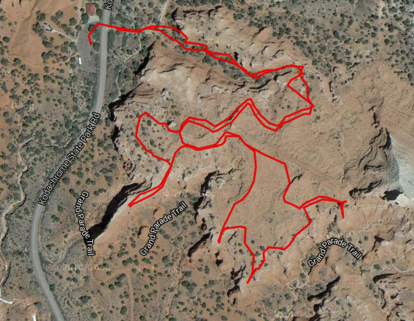
Afterwards, we got off the main park road, driving 7+ miles on the dirt Salt Valley Road to the Tower Arch trailhead.  The Salt Valley Road is listed on the park map but there isn't any sign for the turnoff on the road.  This is presumably to keep the hoi polloi off it since it is impassable in inclement weather:  the road is actually on a soft sand wash for some distance and when it is wet, vehicles would get stuck.  We had to drive very slowly to keep from washboarding but were entertained by the dozens of tiny white-tailed rodents dashing across the road into their burrows.

Old sign en route to Tower Arch

We parked in the small lot at the Tower Arch trailhead and walked into the arch, recognizing two other couples who had been in our Fiery Furnace group.  Despite being several cars at the trailhead, however, we pretty much had the trail to ourselves. 

Just below Tower Arch

The trail wasn't difficult, crossing slickrock for the most part, except for an extended hilly section where we were crossing sand dunes.  Although our legs were experiencing some cumulative fatigue at this point, it was still a nice and easy walk after Gooseberry.

Tower Arch (with all the people hidden)

It was, as so many of these desert trails are, quite scenic.  And when we came around the corner of a sandstone fin and saw the massive Tower Arch looming overhead, we were impressed.  The rock comprising the span of the arch is easily as thick as the opening beneath it - we hadn't known what to expect but we hadn't expected something so huge.  We stayed for a while, gazing at the arch, until the somewhat noisy and annoying group who were there ahead of us drove us away.  (We wish people would use their inside voices when they are outside in spectacular locations like that.)

Heading back on Salt Valley Road

Then it was back to town to clean up for dinner at Miguel's Baja Grill: margaritas, a giant burrito for H and goat enchiladas with green chile and mole for me.  After dinner we swung by Back of Beyond Books (recently given very good press in Neil Peart's Ghost Rider), which is an excellent independent bookstore right in the middle of Main Street, Moab.  They've got everything you could want in a bookstore: tons of local guidebooks, maps and history books, cookbooks, best-sellers and a large collection of old and rare books and maps.  We spent quite a while there, poring over a late 1800s map of Utah before purchasing two quirky books of Moab area day hikes and two maps.  If you're ever in Moab, you should definitely stop by and buy something from Back of Beyond.

Tower Arch trail map (2.8 miles)

Saturday, October 24, 2015

dead horse point and canyonlands

Saturday began with breakfast at the Moab Diner, plus an errand to the grocery store for sandwich and beer supplies, before we drove up to Dead Horse Point State Park for some morning MTBing.  It was a beautiful morning, sunny with just a few scattered clouds, and cool without being cold.  There were just a few other cars in the visitors' center/trailhead parking lot but we knew it would fill up before too long, being such a nice day to be out and about.

H on the trail

We strung together a loop on the Intrepid trail system: Great Pyramid to Big Chief (which is becoming our new favorite up there: technical enough in places that you have to think about what you're doing but also with some great flowy sections and gentle slickrock) to Crossroads to Whiptail and then back to the truck via Raven Roll (16.3 miles).  We saw lots of desert cottontail rabbits and one big, lanky jackrabbit, and we didn't have to share the trail with very many people.

That's me, just a couple of switchbacks 
from the top of the Gooseberry Trail

Next stop was in Canyonlands National Park, which may be my favorite park due to the lower concentration of visitors and high concentration of hiking trails.  We drove out to the Island in the Sky picnic area, also the location of the Gooseberry Trail.  I have been wanting to do this trail since last May when we learned of its existence.  It is a crazy trail, basically carved into the side of the cliff from Island in the Sky to the White Rim plateau.

And that's me, middle of the photo,
several more switchbacks down the trail

When you peek over the edge at the start, you think, "There can't possibly be a trail down this." But there is and the Park Service has done a wonderful job maintaining it.  It is very steep and rocky, with many short switchbacks and steps, but it is absolutely doable.

We came down from between those two knobs

It also loses 1,300 feet of elevation in less than 1.5 miles.  It's STEEP.  Because it's so steep and a little scary, not many people hike Gooseberry, despite it being smack-dab in the middle of Island in the Sky.  We only saw six hikers: three guys in their 20s heading up as we were going down; two young women coming up the wash as we headed out; and one older solo hiker coming down as we started up.

H on flat ground, walking out the wash to the White Rim

After we carefully made our way down the cliff side (which took us an hour, being very careful), we walked out along the wash to the White Rim overlook.  The layer of rock that makes up the White Rim is impressive up close: an overhang approximately thirty feet thick that drops away into the labyrinthine canyons below.  We duly admired the view, had a quick snack and then retraced our steps (an hour, out and back through the wash).

Me at the White Rim

It was fairly hot in the wash and clambering up the rubble-strewn slopes so I was actually grateful when we started up the really steep portion of the trail which was in the shade.  Going up those 1,300 feet in 1.5 miles was a lot of work - probably some of the more difficult hiking we've done - but it only took us 40 minutes to get back up to the top of the trail.

We are headed up between those two protuberances

We weren't stopping for pictures on the way up, for one thing, and we just dug in and put one foot in front of the other.  Reaching the Island in the Sky rim really felt like an accomplishment - we earned our beers on Gooseberry (5.5 miles).

Our route on the DHPSP trails

We went back to the motel to clean up, then had a couple of drinks at Woody's Tavern before strolling over to the very busy Milt's Stop n' Eat.  We had thought to get our meal to go and then eat at the outdoor picnic tables.  The to-go line was huge, however, and when a couple of counter seats opened up, we jumped on them.  Our burgers, hand-cut fries and chocolate shakes were delicious.  Kudos to the hardworking folks working the line at Milt's.

A definitive out-and-back on Gooseberry

Thursday, October 22, 2015

on to moab

Our MOAB Brands loop

Although we loved Bryce Canyon National Park, Red Canyon and Kodachrome Basin State Park, we were ready to move on from Panguitch, hitting the road at 6:45 a.m. Friday morning.  It's over 250 miles from Panguitch to Moab and we didn't want to spend all day driving.  It was actually a very nice drive across a portion of I-70 that we hadn't done before, crossing the San Rafael Swell (yet another place that's on our list to explore, along with Grand Staircase-Escalante National Monument).

Portland represent

We arrived in Moab and got our wheels in the dirt at the MOAB Brand Trails (after H gallantly fixed my mysteriously flat front tire) at 11:20.  We did two circuits of our usual loop:  Rusty Spur and the Bar M loop.  Yes, we know that these are pretty easy trails to ride by Moab standards.  But the loop we've put together consists of good cross-country terrain, with a little climbing, some good flow and a nice mixture of dirt, gravel, sand and slickrock.  I can ride the whole way around without any hike-a-bike and was really riding pretty well that day.  And although the parking lot was fairly busy, we saw hardly anyone out there on the trails, making it extra fun.

There always seem to be clouds over the La Sals

After post-ride beers, we went to Arches National Park, stopping first by the visitors' center in hopes that we might be able to score some Fiery Furnace hike tickets.  We were disappointed to see a sign that all the Fiery Furnace hikes were full until Tuesday ... until the woman in front of us turned around, saying that she had four tickets to the Sunday hike and would we be interested in any of them?  We sure would and, after navigating the park's purchase system, we walked away with two of them.

At the top of Park Avenue

We also walked the Park Avenue trail, one of the few remaining Arches NP hikes we have not yet done.  This is a short hike (just under 2 miles) out and back along a wash under huge red rock walls.  It was fairly warm at this point in the afternoon and we started at the bottom so that we would have a downhill finish.  The formations loom large overhead and this little hike is a good one for students of geology since the rock layers are distinct and easy to discern.

Park Avenue

Having checked Park Avenue off our list, we headed into town and checked into the Kokopelli Lodge.  We showered and then walked down to the very busy Moab Brewery for beers and an early dinner (chile verde burrito and an enormous spinach salad with blackened tilapia).  As we walked back to the motel after dinner, we appreciated being back in a small town with energy and options - poor little Panguitch has nothing on Moab.

Straight shot Park Avenue trail map

Tuesday, October 20, 2015

back to bryce

Bryce Canyon/Peekaboo Trail loop

We were back at Bryce Canyon NP, hiking down the wide trail from Bryce Point at 8 a.m. Thursday morning, our last day in the area.  A busload of tourists shadowed us down for a few switchbacks to take a million photos of the main amphitheater before returning to their bus.  We kept going down, enjoying the easy footing and clear path (but realizing that we were losing a lot of elevation), eventually connecting with the Peekaboo trail.

Heading down from Bryce Point

We continued on Peekaboo counterclockwise until we reached the bottom of the canyon- incredibly encountering no other hikers.  The sun was up high enough to bathe the pink, white and orange canyon walls with warmth and everything seemed to glow.  At the trail junction where Peekaboo, Navajo Loop and the Queen's Garden trail converged, other park visitors started to pour in, most coming down the shorter but steeper trails from Sunrise Point and Sunset Point.

Switchbacks from Bryce Point

We walked the out-and-back to the Queen's Garden where there's a hoodoo that looks (somewhat) like Queen Victoria; we found the formations there a little underwhelming compared to the astounding beauty all around us everywhere else.  Next was the Navajo Loop: we went up (north) past Thor's Hammer and then down (south) through Wall Street.  This short loop trail is only 1.4 miles but it is steep and full of wonderful switchbacks.

Peekaboo junction

When we exited Navajo Loop, we rejoined Peekaboo to finish the loop (5.5 miles total).  I don't even know what to say about the scenery except that it is exceptional: incredible colors and wild formations.  Many popular formations along this loop include the Wall of Windows, the Three Wisemen, the Organ and the Cathedral, although we weren't able to identify most of them ourselves.

Thor's Hammer

We got back on the trail back up to Bryce Point, at this point leaving most of the crowd behind us.  I had thought it was going to be a slog going back up but the ascent actually went quickly.  Because the path is so smooth (for dirt and gravel), you don't have to watch your footing and can just keep putting one foot in front of the other, putting the distance behind you.  The Bryce Point parking lot was bursting at the seams when we got back to the truck - nice weather brings out the tourists.  While we encountered many more people on these trails than we normally do, we still really enjoyed the hikes.  The scenery is just that good.

Going down the Navajo Loop

After a quick lunch at Ruby's Inn, we drove down to the Thunder Mountain trailhead parking lot in Red Canyon.  Two people (including our dentist) had recommended this as a MTB trail: ride the paved bike path to the top and then take the trail back down.  It sounded easy enough but it wasn't quite so simple.  We climbed steadily on the bike path up to Coyote Hollow, then took a dirt Forest Service road in (and up) a ways to the Thunder Mountain trail.

Somewhere amongst the Bryce Canyon rocks

The first half of the MTB trail was great - rolling singletrack that followed the side of the hills with downhills to the left into the forested washes, and then short uphills to the right over the rockier ridges - but it involved more climbing than I had expected/hoped for.  After our morning hike (9.3 miles total), my legs started to get fatigued and I found myself walking some of the short climbs that I should have been able to ride.  A group of four French MTBers passed us here, one of them muttering "Zey told me it was all downhill from here!"

It's all just so dang pretty

Then, about halfway through the ride, the terrain completely changed as we started crossing exposed, rocky ridges and steep side hills, covered with loose, sharp rocks.  We passed the French guys here as they stopped to take photos.  I got nervous and started doing a lot of hike-a-bike, especially on the ridges and downhill switchbacks; even H had to walk more than he would have liked, but a fall could have resulted in bad abrasions at best and it was better to play it safe.  The views were certainly dramatic.

H admiring the dramatic view

We finally got off that section and then, for the last 1.4 miles it was just awesome: rolling dirt singletrack, swooping through the trees and across dry washes, and all downhill.  I don't think I had to pedal more than five or ten strokes.  It was super-fun and was a fantastic way to end the ride - and I was particularly pleased that the French riders never caught back up to us.

I'm in there, waving at the camera from the crazy terrain

When we got back to Panguitch, we did some laundry at the Hitching Post RV Park and then returned one last time to the Cowboy's Smokehouse Cafe for dinner (pulled pork for H and, you guessed it, chicken fried steak for me).  Oh!  And we had some new animal sightings on the day:  prairie dogs in Bryce Canyon NP and pronghorn antelope in the fields outside Ruby's Inn.

Thunder Mountain MTB trail map

Sunday, October 18, 2015

kodachrome basin state park


Morning cow in the road

We got out to Kodachrome Basin State Park around 8 a.m. on Wednesday - not having found anywhere in town we wanted to try breakfast means quicker morning starts.  It's a wonderful state park, with good-looking campsites  as well as some cabins and a camp store on the ground, plus several hiking/biking/horse trails.

Looking out at the basin from Angel's Palace trail

We walked three of the trails in the morning.  Angel's Palace is a short one (1.6 miles), winding in and over red rock ridges and hoodoos, with wonderful views of the Kodachrome Basin.

H elevated

Grand Parade is also technically 1.5 miles, going through the basin floor, but you get a little more mileage with spurs into two fairly impressive box canyons which we entered by walking up the washes (2.5 mi. total).  The lower canyon walls were covered with a soft mud, reminiscent of Goblin Valley, carved into rivulets and formations by runoff.

Dead tree art shot

The Panorama Trail is longer, 3-6 miles depending on the loops you want to connect; we did just over 6.  This trail is on the other side of the park and is drier.  There's hardly any elevation gain, just going up and down some easy washes, and there are several interesting features like the Ballerina Spire (a white sand spire, as opposed to a hoodoo) Secret Passage (a narrow carve-out into the cliff walls) and the Cool Cave.  We mostly had the trails to ourselves, except for a small group who was in the Cool Cave when we got there and then a few other hikers whom we passed on our way out to the car.

In the Secret Passage

After refreshments, we moved the truck from the trailhead to the visitors' center lot and hopped on our MTBs, planning to ride out to Grosvenor Arch.  Access was via a sandy dirt road at the turn-off to the state park road.  Despite it being a wide dirt road, I struggled here: it was pretty sandy, which made me nervous and sucked up a lot of energy; and it was a net climb for eleven miles, with several long and steep hills that I had to hike-a-bike, and which then lost all the elevation on the downhill, only to climb again.

Heading out to Grosvenor Arch

I actually turned around after eight miles, leaving H to power on by himself.  The good thing was that after dealing with the long hills, it was a nearly all downhill return, with pauses to address the perplexed range cows.  These cows are used to seeing people in cars and trucks but bicyclists seemed to confuse them.  I waited for H back at the entrance to Kodachrome, engaging in a staring match with a calf, and then we rode the last mile together back to the truck.

Grosvenor Arch

Back in Panguitch, we returned to the Cowboy's Smokehouse Cafe for dinner (sausage platter for H and chicken-fried steak for me).  It was pretty busy, the word getting out about it being the only real game in town, I guess.  Their prices seemed a little high for the dinners we were getting but since we weren't spending much on food otherwise, it was averaging out.

Angel's Palace trail map

The weather: finally gorgeous, mostly sunny and 32 F in the morning, with a high of 72 F at the end of the day.  It was a great day.

Grand Parade trail map (note box canyons)

Panorama trail map