Monday, December 30, 2019

christmasy

It feels like it's been forever since we've seen the sun: nine of the last ten days have been cloudy.  With these clouds, we've been getting some moderate snowfall up in the mountains, so that's good.

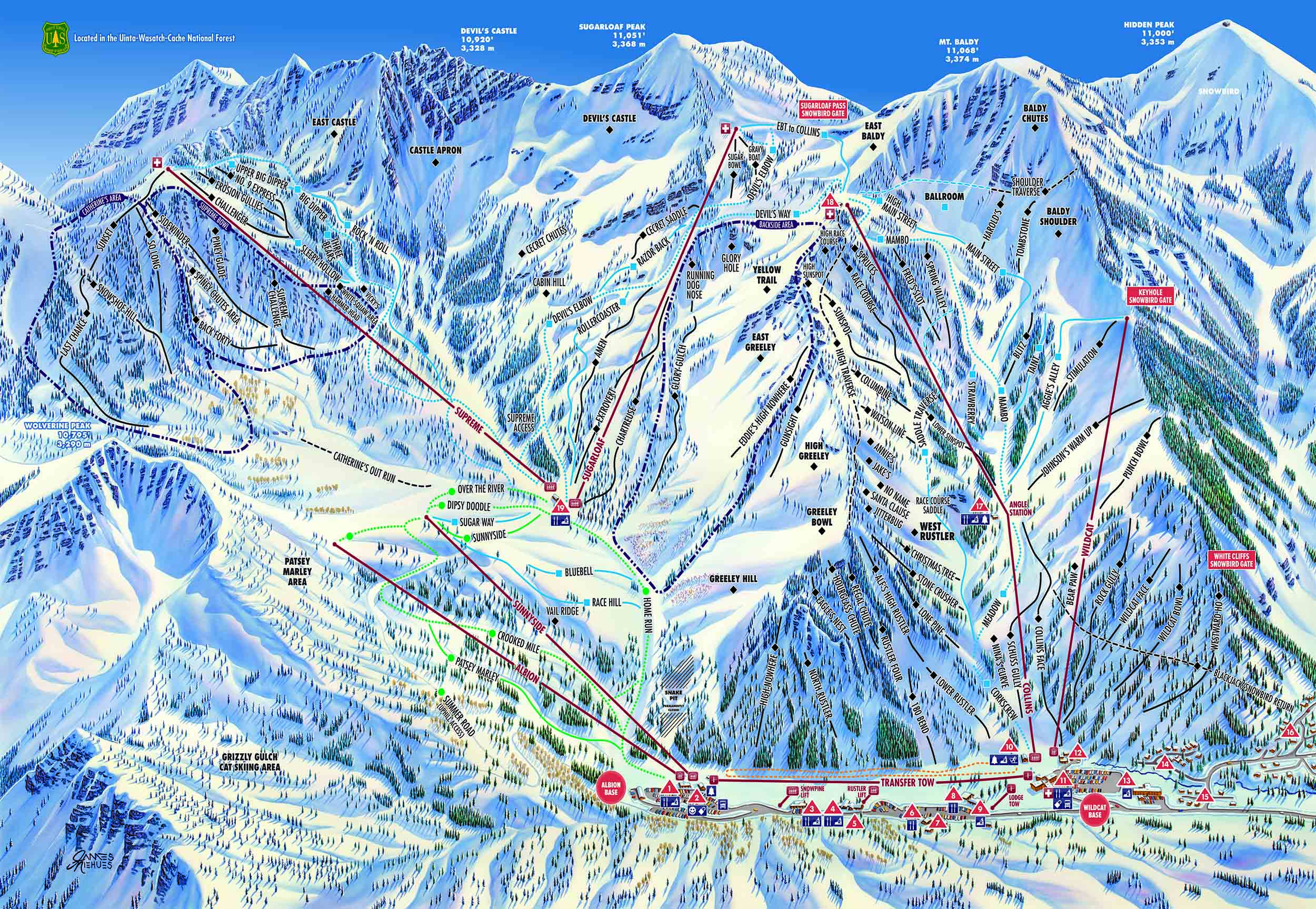
Christmas Eve: East Greeley scene 

H skied Christmas Eve all day (and ended up running for the 4:45 bus to come home) and went all over the mountain: Extrovert, Sunspot, Racecourse, off the High Traverse, East Greeley, Eagle's Nest.  It lightly snowed all day then started coming down heavy at the end - he said it was practically dark for the last two runs. 

In the vicinity of Eagle's Nest, with the rope tow far below

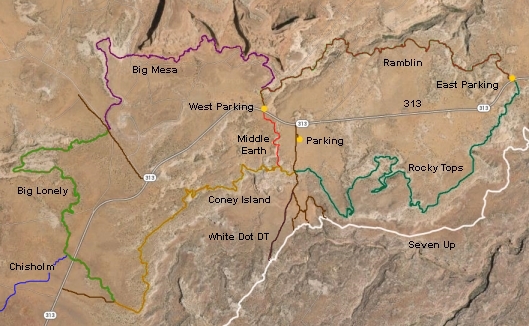
And in case you were wondering, the tourists have definitely arrived.  The corrals were packed, there were all kinds of lift line shenanigans (how is it that these people don't know how to load a chairlift?) and it was difficult to find a place at Alf's for lunch, even with all the new tables. 

 Christmas Day: Backside

Christmas Day was relatively busy in the morning ... and also cloudy/snowing all day.  Visibility was pretty poor but the snow was pretty good.  To be honest, these photos don't look like Christmastime photos - there's quite a lot of snow.

 Christmas Day: Catherine's Area

I had to go back to work for a few hours for Boxing Day (we were heading down to Moab for a long weekend) but H managed to get back up to Alta for a morning of skiing.  The heaviest snowfall had moved on by then and some cold air was coming in behind it.  He only skied 9 a.m. - 1 p.m. and his toes were still achy that night from how cold they got.  I wasn't sorry to have missed that, although H is definitely pulling ahead of me in the ski days now (like he always does).

Boxing Day: looking up at Devil's Castle


Friday, December 27, 2019

they're coming

Sunday at Alta: warmer, cloudier and beginning to get busier as the Ikon pass people start to arrive for the Christmas holiday.  Sigh.  We knew they would get here eventually. 

After an uneventful bus ride up to Wildcat base, we learned that there was a half hour delay on opening the Collins chair; apparently it had been very windy Saturday night and some of the sensors had gotten knocked askew.  People were bailing out of the lift line for the Wildcat chair but we took a different route and did a reverse Around the World: taking the rope tow to the Sunnyside chair (which now features a singles line), skiing down to the Sugarloaf chair, and going around the EBT back to Collins, which was by then open.  Basically we took three lifts before skiing a single run. 

We then stayed at Collins for a while.  The snow was firmer and more skied off than it had been teh day before and I thought taking Spring Valley to Strawberry was the best snow.  When we returned to Sugarloaf, Sugarbowl was holding up (surprisingly), Razorback was still skiing pretty well and Rollercoaster was pretty good, as were the trees between it and Extrovert. 

Same outfit, different day

We did an early and quick lunch at Alf's and then were at Supreme for the next couple of hours, just doing laps over there.  As it started to get busier, it was like dodgeball getting around the cat track and down Upper Big Dipper - the new quad lift brings so many more beginners and lessons to Supreme.  Sigh.

I took the 2:36 bus back down to the valley (I just missed the 2:04 so I got a beer at th Goldminer's Daughter lodge while waiting and got carded!).  H skied all day and got home tired and hopeful for some new snow soon.

Tuesday, December 24, 2019

open for business

After what seemed like ages (but was really just one non-skiing weekend), we were back to Alta.  Saturday was reasonably temperatured at 26 - 38F, and while mostly cloudy, it didn't even seem cold with the south wind.  I managed my outfit fairly well: I was warm when skiing, and cold on lift in the morning but fine after lunch when it was slightly warmer.

There was plenty of room on bus going up.  With no new snow for several days, people weren't clamoring for freshies.  Alta had almost all its terrain open - except East Castle and Baldy Chutes, and Baldy had been open earlier in the week - and the snow was pretty beat and wind-buffed.  It was still fairly soft, all things considered, except for a couple of scraped off spots on high traffic areas like Upper Big Dipper.  H did one run down Sunspot which was firm and bumpy and hard to see with the very flat light; he said he felt it in his legs immediately.

We started off on Collins and did about five runs there, including Ballroom which was decent but very difficult to see in the flat light.  We had that flat light pretty much all day, except for one or two peeks of sun - we scoffed at the "partly cloudy" claim in the forecast.  We moved to Sugarloaf next, which was a much windier chair, per usual.  Although both Backside and Devil's Castle were open, we saw very few people venturing in.  We did a little bit off the groomers: Razorback was skiing quite nicely and we didn't hit any submarining rocks.

In the Ballroom

After lunch (we saw our favorite cashier, Carrie, back for her winter break), we skied Supreme.  Although we are now resigned to the "new" chairlift there, and we don't hate it as much as we did, we still both miss the old Supreme chair a lot.  Challenger was bumped up with big moguls, although they were fairly soft.  I rated it skiable but was never able to get into any rhythm due to the size of the bumps.  Rock 'N Roll also skied quite well but there were tons of people on it each time we skied it.  3 Bears was also pretty soft and not skied off but it will never be my favorite trail with its cross-fall line orientation.

I skied out to catch the 3 p.m. bus while H kept skiing until last chair.  He wasn't quite as wiped out as he had been after the storm day we had two weekends ago, but he was still tired enough that he went to bed at 7:30.  Milton, who slept all day on the bed while we skied, had no problem joining him - that dog loves to sleep.

Saturday, December 21, 2019

more fins, more things

It was about ten degrees (Fahrenheit) colder on Sunday, plus dark as we were a week away from the winter solstice, so we didn't get out onto the trails until just after 10 a.m.  Continuing with our plan to do busy trails in the off-season when they aren't busy, we decided to return to Fins N Things, this time in reverse, going in the exit and walking against the traffic.  If there was even going to be any traffic.  There really wasn't much going on out at the Sandflats Recreation Area: the guy manning the fee station just waved us through without bothering to check our pass.

 Pretty easy to follow the 4x4 trail

Although it got a little brighter as the day wore on, it was breezy and never warmed up enough for either of us to take any layers off, despite the steep, short climbs we were doing out on the sandstone.  This 4x4 trail (or at least the six+ mile portion we did) was about half slickrock features (the "fins") and half dirt/sand jeep tracks (presumably the "things").

Milton on a fin

We only saw two jeeps while we were out there and again marveled at having this wonderful, beautiful place to ourselves.  It'll be good to remember this later this summer, when it's over 100 F and the Sandflats are swarming with OHVs.  Milton was very happy off-leash and did quite well coming right back to us when we met those two jeeps.

All the different layers and levels

The whole route is over nine miles, too far for us this day.  We planned to exit via the radio tower cut-off but when we got there, we saw a short out-and-back to a scenic overlook that we figured we should check out.  We're very glad we did because the view is down into the upper reaches of Grandstaff Canyon and we found a trail leading down into the canyon that we will go back to explore.

Winter desert

We retraced our steps back to the cutoff, then took it out to the Sandflats road.  From there, it was less than a mile back to the truck, where our beers were waiting.  As we stood there, watching the rarely passing vehicle traffic, we realized that cold beer is not the best post-hike beverage in December.  As we still have a lot of winter exploring to do, I sense hot chocolate and peppermint schnapps in our future.

Hike stats:  6.66 miles; 2:20 / 2.8 m.p.h moving; 2:37 / 2.5 m.p.h. overall; 980 feet elevation

Tuesday, December 17, 2019

porcupine rim

Timing is everything.  For example, we scooted out of work early on Friday and drove south to Moab ahead of the latest storm, with dry roads and light traffic the whole way down.  We got to Woody's in time for a couple of beers before the Friday night DJ kicked into gear - timing is everything.  And when we did our hike on Saturday, we managed to avoid most of the weather that was threatening, with only a few sprinkles to dampen things.

 Heading up under cloudy skies

Moab is pretty empty right this time of year and we're loving that.  It's for good reason: it's relatively cold (low to mid 30s throughout the weekend and the sun never really came out) and the trails can be wet/muddy.  But the trailheads are nearly deserted so we're trying to take advantage of that, getting out on trails that see high traffic in the high season.

He's a blur

On Saturday, H suggested that we do some of the Porcupine Rim trail, starting at the Colorado River.  This is the end of the Whole Enchilada MTB trail: super-popular and one of Moab's most iconic rides, starting the the LaSal mountains and ending up at the river.  I've been wanting to ride the Whole Enchilada; after walking the bottom 3.5ish miles, I'm thinking that it's above my skill level.

Much greener than we expected

It's great hiking though.  We parked at the large-ish lot at the end of the trail, walked through the bike tunnel under the road and started climbing.  As we got away from the road, we let Milton off his leash, pausing only to let a single MTBer ride by.  That was the only person we saw the whole time.  The trail is nice to walk on, combination dirt/sand and trickier rocky sections.  It's never really steep but it does climb steadily and before long, the Colorado River was far below us.

High above the river

As we wrapped around a corner, the wind picked up a little bit, coming down Jackass Canyon's steep cliff faces.  We made it up to the rim, where the singletrack segued to a jeep road.  At this point we'd been out for about an hour and a half and as it started to sprinkle on us, we figured this would be a good spot to turn around.  Milton, who has yet to learn to pace himself, slowed down a little for the return trip.


It was spitting rain when we got back to the truck so instead of post-hike beers in the parking lot, we drove a little ways downriver to one of the campgrounds and utilized one of its shade pavilions to keep dry.  In the spring/summer/fall, these campgrounds are packed to the gills; show up in chilly December, however, and you get the place all to yourself.  Timing is everything.

Looking down Jackass Canyon to the Colorado River

Hike stats:  6.74 miles; 2:26 / 2.8 m.p.h. moving; 2:45 / 2.4 m.p.h. total; 1,120 feet elevation


Thursday, December 12, 2019

better on the second day

And on the second day of our 2019/2020 ski season, it was very, very good!  An overproducing storm showed up early Saturday Sunday morning.  It was raining/graupeling at home when we left to catch the bus; it had changed to snow at the mouth of Little Cottonwood Canyon; it was nuking when we got up to Alta.  We timed it just right on the roads too: by 10 a.m., there were reports of multiple slide-offs, including two ski buses.

Because of the potential for sketchy road conditions, I had decided to head back down canyon after lunch, not wanting to leave Milton stranded in the event of traffic congestion.  That decision seemed to have been slightly prescient - not because the traffic ended up being bad (it wasn't, really) but because by noon my second-day legs were crying uncle.  The snow was deep!  And soft!  And really fun!  But it was a lot more work than I expected to be doing on my second ski day.

NUKING (even at the base)

There was limited terrain open, due to both avalanche issues and base depth, but we found plenty to ski, even just doing laps on the front side: Mambo, Strawberry, Spring Valley, Sunspot, etc.  The main traffic patterns got chewed up quickly but all you had to do was go into the trees a little to find fresh snow.  Visibility was difficult as it was either snowing or in the clouds, or during the fifteen minute stretch when it wasn't actively precipitating, the light was very flat.  Still, that 6-8 inches was super-fun and we could hear a lot of hooting and hollering - clearly everyone felt the same way.

I caught the 1:30 p.m. bus down canyon, walking home from the bus stop in a light drizzle.  H told me that he didn't imagine that he would ski past 3 p.m.  I secretly rolled my eyes at this and when I got a text from him saying that he was going to be on the 4:15 p.m. bus, I wasn't surprised.  He was wicked tired when he got home (and would have sore quads on Monday), just barely managing to get through early dinner before crashing.  "I might have overdone it," was the last thing he said to me that night.  True, but completely understandable when the early season snow is just that good.

Monday, December 9, 2019

good start

And just like that, we're skiing!  Milton was not impressed Saturday morning when H and I scurried around, packing our boot bags, dragging ski pants and jackets out of closets and generally not taking him hiking.  He's a good boy, though, and he just went back to bed as H and I drove to the park-n-ride at 7:30 to catch the ski bus to Alta.

We sure do love early season: we got seats on the bus, we got a table at the Goldminer's Daughter, we never waited too long in the lift lines (although we did ski the singles line a bit) and we got our favorite table at Alf's.  And this year, early season even came with good snow: while the Thanksgiving weekend snowstorm hasn't been supplemented with much new snow, the base at Alta was over 45 inches - and that covers quite a few rocks.

Quick! Take my picture before it gets cloudy!

The weather report said high 20s/low 30s and partly sunny and that wasn't entirely accurate.  When we skied the Collins lift, it was warm at the base (38F max) and the sun was in and out.  Up at the top of Collins and over on the Sugarloaf side, however, the wind was pretty strong and clouds had settled in.  It was COLD.  Unfortunately, that meant the majority of the skiers were skiing the front side, making for longer liftlines and high traffic areas that got skied off quickly.

Still, the snow was quite good, all things considered.  We skied together the whole time: this was our first day back on skis and it was clear that neither of us has done much in the way of conditioning for the season.  We were in no shape for off-piste and so stuck to groomers for the duration; H checked out the conditions in Ballroom and found them firm, and although Extrovert got opened after lunch, you could tell that there were rocks lurking just beneath the snow's surface.  We skied until after 2 p.m., then caught the ski bus back down, again enjoying the lack of crowds.  Even though it was relatively early, the only plan for the afternoon was to nap with the dog and rest up for day #2.

Saturday, December 7, 2019

thanksgiving weekend, part 2: sunny

It rained all day on Friday, tapering off just in time for us to walk to Woody's for 5 p.m. beers, and then the storm moved out of Moab, leaving mostly clear skies and chilly temperatures behind it.  Perfect hiking weather!

Boys hiking

Back in August, when we rode the Navajo Rocks trails, we discussed doing some winter hiking on the 4X4 that ran under the Entrada cliffs.  Once we got out there, however (and were only the second car in the parking lots because brrrrr), we ended up on the Ramblin MTB trail which followed the line of the cliffs but weren't right under them.  We descended wide level benches of slickrock, crossed a couple of washes (including what we think is the head of Seven Mile Canyon) and went through some rolling sandy patches before ending up at a small parking area at 313.  This would be a fun MTB ride - I think I could ride a lot of it - but it's only a little over three miles long.

Monitor and Merrimac from Ramblin

At this point, we had a decision to make: retrace our steps on Ramblin, for under seven miles total, or make a loop by crossing 313 and heading back up via Rocky Tops and Middle Earth, which would put our mileage over nine.  We didn't want Milton to overdo it but watching him out there, happily chasing a golden retriever across the rock and clearly loving being out here, we decided to take the long way back.

Views wherever you look

As far as MTBing goes, Rocky Tops is rather more technical than Ramblin; as far as hiking goes, it's terrific.  For the duration, we kept passing and getting passed by a couple groups of MTBers: they would pass us on the flats and then we would catch and pass them on the more technical sections.  There's a little bit of everything out there on those trails, from doubletrack to sandy singletrack to steep switchbacks to sidehill sandstone to rolling slickrock benches.  It would be a very hot hike in the warmer months - there is no shade out there at all - but it was fantastic in early December.

When we got back to the parking area, it was PACKED.  A big group next to us was making tailgate coffee and brunch post-ride; there were several dogs for Milton to meet; other people were just warming up and heading out on the trails.

Map from utahmountainbiking.com (great site, tons of 
information) because our GPS's batteries died mid-hike

We knew we had to drive back to SLC on Sunday but the roads were clear and the weather calm, which meant that we had time for a hike before hitting the road.  We thought we would go early-ish to take advantage of the chilly morning temperatures and walk the Hell's Revenge 4x4 Trail up at the Sand Flats Recreation Area.  This is a very popular OHV trail but those folks seem to wait until it warms up before putting their vehicles in drive.  We figured we'd get out ahead of them and that's exactly what we did.

Image result for hells revenge trail map

We parked at the exit to Hell's Revenge and went around clockwise.  Hiking on OHV trails is a mixed bag as sometimes the dirt is chewed up, sloppy and difficult to walk on.  Hell's Revenge had some slippery sections but it also had firm dirt surfaces as well as slickrock stretches, so it wasn't that bad.  It did gain quite a lot of elevation, however, and despite how cool it was, we had to delayer to keep from sweating too much.

Ridge-walking

Our plan worked and we saw no one out there until we switched to the Slickrock MTB trail around the Escalator obstacle.  From there it was still two miles out to the trailhead (we would total over five miles on this one) and we saw several MTBers as the day got warmer.  It was a ghost town compared to the spring/summer/fall, however.  I anticipate more hiking up there in winter solitude.

Thursday, December 5, 2019

thanksgiving weekend, part 1: stormy

Because of the big storm that blanketed most of the state for Thanksgiving, we hightailed it out of SLC after work on Tuesday, rolling into Moab around 10:30 p.m.  It wasn't the most relaxing drive since it was all after dark, plus evening commuter rush through Provo, but the roads were dry and once we got off I-15, there wasn't much traffic.

H and I both worked on Wednesday, although Milton and I managed to get out for a quick walk up at Sand Flats Recreation Area.  When we stopped at the entrance to show our pass, the lady warned us that the dirt roads had been treated with magnesium chloride - I think she was concerned about Milton - and when I said we intended to do the Practice Loop, she smiled and waved us on.  It was windy and chilly and there were patches of snow and ice out on the slickrock.  We saw a handful of MTBers (most of them on their way back to the trailhead as the wind picked up) and a couple of hikers.  Milton got to stretch his legs and run-run-run: he really seems to love slickrock hiking and some of his jumps are impressive.

Blustery out on the rock

On Thanksgiving, H and I got our hiking stuff on and drove out to Delicate Arch in Arches National Park.  It had been quite a while since we'd done that hike (since our sunset hike in 2013) and we thought Thanksgiving morning might be a good time to do it again.  We were rather taken aback to see that SO MANY other people thought the same thing.  The main trailhead parking lot wasn't quite full when we got there but it did fill up while we were hiking.  We did our best to be patient, however, and managed to pass oodles of people once we were on the steep slickrock ramp that leads up to the ridge.

Hang onto your hat!

It was cool and breezy as we ascended.  Then, when we turned the last corner and stepped out into the sandstone bowl that surrounds the arch, we caught the full force of the wind: H nearly lost his hat and I actually had to sit down a couple of times to keep from being blown over.  On the plus side, those crazy winds dissuaded people from lingering too long, taking in the scenery, and H was actually able to get a photograph of the arch without any other people in it.  Amazing!

Blustery out on the rock

We descended quickly, as still more and more people were heading up.  We heard one girl remark, "There really isn't any off-season anymore," and that seems pretty accurate.  It's always post-hike parking lot beer season, though, and we took care of that before heading back to Milton and the rest of our quiet Thanksgiving.  FYI:  the Moab Brewery is open on Thanksgiving (Woody's is not), in case that is something you need to know.

Monday, December 2, 2019

thankful

For only the second time since we moved to Utah, I missed the City Creek Cold Turkey run Thanksgiving morning.  Why?  Because we went to Moab (shocker).  That meant that we also missed opening day at Alta and a HUGE storm that came in Wednesday through Saturday, slamming most of the state with snow - the Abajos, down south of Moab, got 40+ inches - making for an all-time excellent start to the ski season.  (It also made for a slippery, messy mess on the canyon roads; H saw tweets that at least two buses and a couple of semis slid off Little Cottonwood Canyon Road.

We had a mix of weather and weather-related activities and as soon as we've downloaded the photos, I'll get a post up.  Until then, please enjoy this photo of our handsome dog, posing on Hell's Revenge.

Bandana-wearing adventure dog

Tuesday, November 26, 2019

pace yourself

The weather is beginning to change here in Utah - just in time for the big Thanksgiving travel days - so we thought we should go over to Park City one last time until spring (we do everything we can to avoid going to Park City during the winter since Parley's Canyon can be so treacherous).  Saturday was forecast to be the better of the two weekend days; we got our hiking stuff together, threw Milton in the car and were on the road by 9:30 a.m.

Momentary pause

We had initially planned to hike the Glenwild area but when we pulled in to the small parking lot, we saw a new [since we had been there last] sign saying that dogs had to be on leash.  We wanted Milt to be able to run, so we piled back into the car and drove to the North Valley Trailhead of the Round Valley trails instead.  At the trailhead there was a pack of five dogs heading out with their people, a pack of five dogs finishing up with their people and a lone fatbiker; other than a couple of trailrunners towards the end of our hike, we really didn't see any people out on the trails.  We didn't see any critters either but there were TONS of deer / rabbit / squirrel tracks.


That's a nice sky

The sun was out and melting the frozen dirt so the trail surface varied from packed snow to slick mud.  For the most part, we were able to stick to snow, rock and dry dirt although we did notice that a couple of trails had been closed to protect their surfaces.  We started out going up Happy Gilmor, then switched to follow some equestrian trails up to the ridge.  These equestrian trails differ from the MTB trails in that they pretty much go straight up, instead of working their way to the top via innumerable switchbacks.  When we reached Rademan Ridge, we went down Rambler, crossed Round Valley Express and Rambler, and started climbing again on the faint doubletrack where the buried pipeline goes.  Up and over the top, we jumped onto Rusty Shovel at the point, took it down to Ramble On and then turned left on Ramble On.  From here, we took the connector to Round Valley Express, crossed there and followed the unnamed trails back to the trailhead.

Beginning to look wintery

Milton looked like he was having so much fun.  He must have doubled the mileage we did (we did around 5.5 miles), ranging far afield and then sprinting back to us, pouncing on things both real and imaginary, and just running-running-running.  He did start to slow down a little towards the end, when we got on Ramble On, and when we got back to the car, he laid right down on the towel we put out for him.  Once home, he crashed - hard.  "Pace yourself" is not part of his vocabulary at this point.

Hike stats: 5:48 miles; moving 2:00 hours / 2.7 m.p.h.; overall 2:12 / 2.5; 700' elevation

Thursday, November 21, 2019

sol-bright 2019

Shoulder season continues: wherein we have to do yardwork (there's only one tree in the front yard but SO many leaves) and errands (my MTB had a squeak) on Saturday but get out for a quick hike on Sunday.  With ski season purportedly just around the corner, it was time for our traditional Sol-Bright hike.

 Tradition

It was mid- to late-morning by the time we pulled in to the parking lot at Silver Lake (closed for the season, with the nordic center not yet open).  There were plenty of parking places still, although there were people milling about; by the time we finished up, it would be pretty busy with people strolling the boardwalk in their city shoes, slipping on the ice.  We could see a few people out on the lake playing pond hockey - no moose sightings, however.

 Wolverine Cirque looking a little thin, snow-wise

We started out going counter-clockwise on the boardwalk, then turned right towards Lake Solitude, then took the left fork so that we would be going up through Brighton and returning down through Solitude.  It was cool to start, especially in the shade, but we were already peeling off layers as we started the climb above the lake.  The sun was bright and it felt good.

 A rare hatless H photo

We passed a couple of groups of people but once we were above the frozen reservoir, we didn't see anyone else - until we got to the top of the Summit chair (RIP the wonderful old double chair that used to be there), where there were a couple of guys working.  I always forget how steep it is hiking up Liberty/Dynamite/etc.  It is STEEP.  But there had been several snowmobiles up and down before us so the footing was good: not slippery and no post-holing.

 Not much snow yet in the hills behind me 

We lingered up at the top for a few minutes, making our way around the corner to take a look at Wolverine Cirque.  You could see ski/board tracks all around but nothing recent; there had been rather more snow earlier in the week before the sun came back out.

 Honeycomb Canyon

For now, however, we were enjoying the sun.  We made our way down through the Solitude side, making really good time until we got into the trees after Lake Solitude.  Then the trail got quite icy and we had to pick our way carefully to as not to take a digger.  Some microspikes or Yaktrax would have helped.

Cheers for post-hike beers

When we got back to Silver Lake, we continued around the boardwalk, just to finish up the loop.  As is tradition, it was time for parking lot beers - with a toast to the upcoming ski season.  All hail Ullr!

Hike stats: 5.05 miles; moving: 1:55 time / 2.6 m.p.h; overall: 2;32 time / 2.0 .m.ph.; 1,340' of elevation

Saturday, November 16, 2019

middle earth

On Sunday, we got going a little earlier than we had on Saturday.  Since we were going to hike, we didn't need it to warm up so much; since we had to drive back to SLC, we did need to be timely about things.  To pick our hike, we got a little unconventional: we had a Google Earth image of the Colorado River as it left Moab and we studied the various canyons coming off the Potash Road until we found one that looked likely.  As we headed out, H remarked that since we knew nothing about where we were going, it could be a total bust.  Milton, proudly wearing his harness, looked like he wouldn't care if it was a bust or not - he was just glad to be going.

Milton in motion

We parked at the [much larger and improved since I first was there] Corona Arch trailhead, already busy with people and dogs.  Leaving all that behind, we walked back up Potash Road, intending to explore Bootlegger Canyon.  Although all that seems to be online about Bootlegger is that the Union Pacific railroad runs through it, below Corona Arch, from our photograph it looked likely enough, especially the right fork that the railroad tracks did not go through.  Unfortunately, the lower canyon was thickly choked with vegetation and after a fair amount of futile back-and-forth, we realized we weren't going to get far without a machete.  According to our photo, however, just a little way further up the road was another canyon that led to the Middle Earth waterfall*.  There had been a car parked there when we'd driven past but by the time we got there, that car was gone and we had the whole hike to ourselves.  Given how busy the Corona Arch trailhead was, this was great. 

Love the light in this photo

As soon as we'd gotten away from the road, we let Milton off his leash.  While he loves hiking in general, he really loves this kind: we were walking up the sandy wash in a narrow canyon, high cliff walls looming overhead, so he could run way ahead and then sprint back to us, knowing that we couldn't wander off.  It was cool in the shady depths of the canyon - we even found big icicles growing out of a slow-dripping spring in one rock wall - and the light was beautiful.

Really pretty place

When the canyon ended, it was in a huge, round, high-walled bowl with a deep sandy bottom.  There wasn't any water coming over the pour-off but we could see that it must be dramatic in a heavy rain.  At one side of the bowl, the slickrock ramp was gradual enough for us to climb out of the bowl.  As we gained the sandstone ridge (littered with curious, dark, rounded stones), we looked up and laughed.  There was Corona Arch straight ahead of us: we could see scores of people wandering around beneath it.  That meant that the canyon below us was Bootlegger; we looked down the canyon and thought we could pick out how far we'd gotten. 

Following the faint trail

We explored along the canyon rim for a while but couldn't find any way to get down into it, so instead of making a loop, we headed back the way we came.  Ain't nothing wrong with that.

Corona Arch

Hike stats: 4.88 miles; moving: 2:00 hours/2.4 m.p.h.; overall: 2:31/1.9 m.p.h.; 710' elevation


*  The Middle Earth waterfall post on gjhikes.com - where we get a lot of good hiking information - describes a completely different hike (starting by the Jeep Arch trailhead) that ends at a completely different waterfall.  But other online sources seem to indicate that where we were is what is commonly known as Middle Earth.  So now we're going to have to go back and check out gjhikes's trail.  Hooray for more hiking!

Friday, November 15, 2019

whoops!

Well, that week just totally got away from me!  I'll have a real post up tomorrow about the pretty little hike we did last Sunday.  Until then, here's a rock bowl and blue sky:


Tuesday, November 12, 2019

what a nice day out there

After the frigid week we had, Utah has been in a high pressure situation for a while.  We thought we'd take advantage of the lack of precipitation and head to Moab for a quick weekend away.  Technically it's a long drive (around four hours) but mentally we have it broken down into four chunks - SLC to Spanish Fork; the twisty bits through Spanish Fork Canyon, over Soldier Summit and down through Price Canyon; Helper to Green River; and Green River to Moab - and for some reason that makes the trip go by fairly quickly.  Luckily, we were able to go down Friday late afternoon, so that gave us all of Saturday and part of Sunday to play.

H on Rusty Spur

Even with the sun and clear skies, it does take a little while for temperatures to warm up this time of year.  Both weekend days were in the low 60s with barely any wind - simply glorious.  We did wait until about 10:30 a.m. to go MTBing on Saturday, however, and when we got to the Moab Brand Trails parking lot, we were completely surprised to see so many vehicles there: at least thirty, as many as we've seen probably since May.  It seems we weren't the only people wanting to enjoy the nice weather.

Psyched to explore this

Somehow, despite the number of vehicles (either pick-up trucks, Sprinter vans or Subarus) we saw very few people out on the trails.  We did Rusty Spur to the climb up to the Bar M loop, then did an out and back on the jeep road portion of Bar B to check out the back entrance to Arches National Park (which we will be exploring on foot later this winter).  Back at the Bar M, we detoured on the Circle O trail, which is fast becoming one of my favorites.  It's all slickrock and I can ride much of it.  It's really fun (despite the serious look on my face in the photo below).

SO focused (trying not to fall over)

After the Circle O, we continued on the Bar M loop, then took a short connector road to the Pipeline road back to the parking lot.  From there, we went around again, this time on Lazy EZ ("neither all that lazy nor all that easy," per the sign - slightly technical one-way single track) across the front of the facing ridge, then around on Bar M to the parking lot cutoff.  It ended up being about eighteen miles; I hadn't been on my MTB for weeks and my legs were tired.

Firepit

It was so pleasant that we stayed in the parking lot for a while with our beers, watching the riders and hikers and dogs and kids all around us, until we needed to head back to let a patient Milton out.  That evening, as you can see below, he wasn't too sure about the firepit.  We liked it though.

Milton is unconvinced

Ride stats: 18/53 miles; 2:26 hours; 7.8 avg. m.p.h.