Sunday, May 29, 2022

sand and hills and rocks and rings

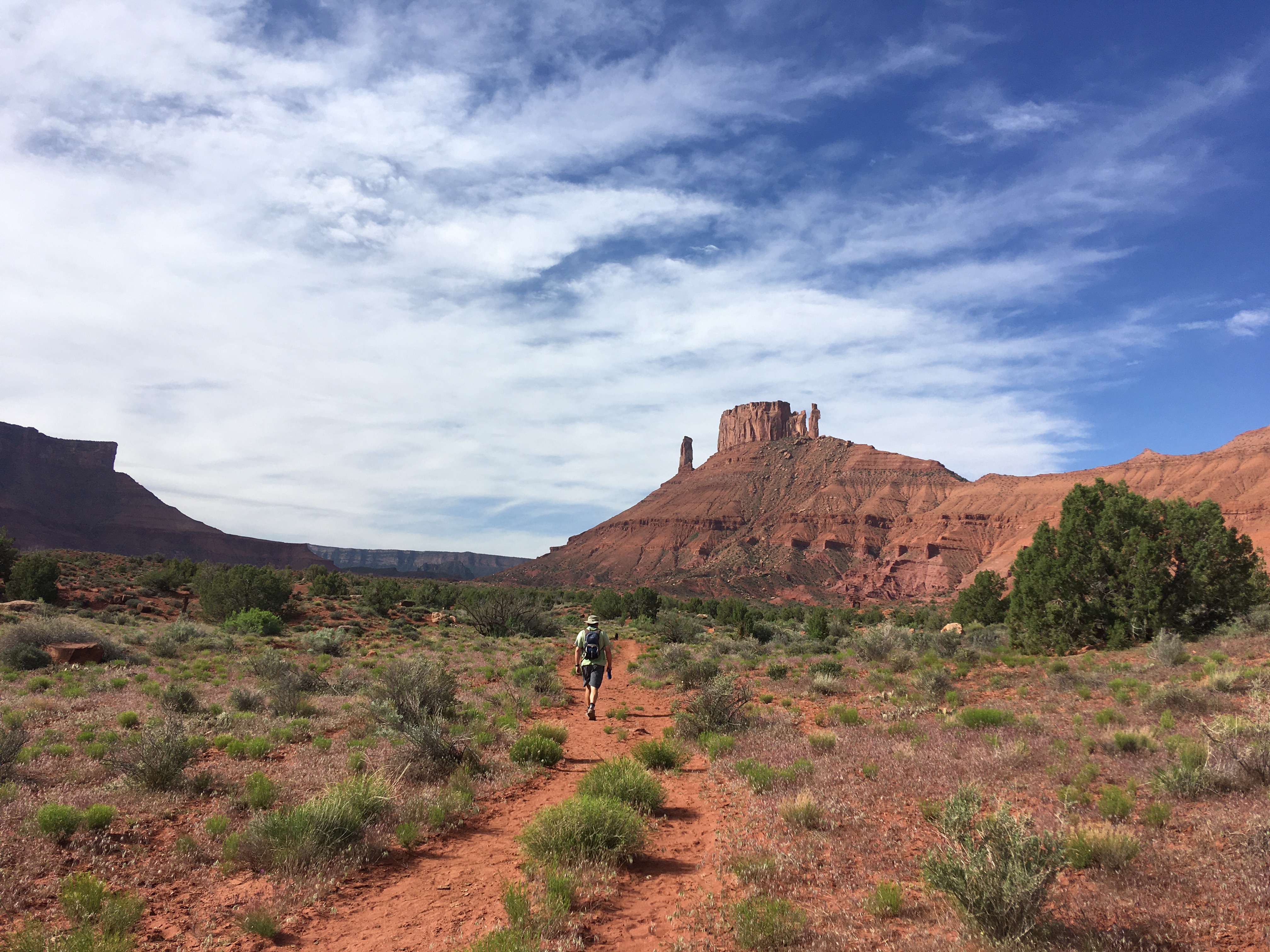
While my suggestion for the Mill Canyon MTB ride wasn't the best (I mean, it was beautiful and certainly not a waste of time, but lordy was it sandy), I redeemed myself somewhat with my choice for the next day's hike: the Sylvester Trail in Professor Valley off Route 128.  When you drive out to do the Mary Jane slot canyon hike, there is another trail at the trailhead, the Sylvester Trail.  Unlike Mary Jane, Sylvester is actually signed; also unlike Mary Jane, there is absolutely no water out there.

Hitting the trail

There was only one other car in either parking lot when we arrived at the trailhead at 9:30 a.m.  Mindful of how busy this trailhead can get, we backed in to make for easier egress.  As it turned out, weekdays are much quieter out there than weekends: while there were several other vehicles there when we got back, we had only seen two other people and their dog out on the trail ... and they had meant to go to Mary Jane anyway.

Dang cows trampling everything

The trail is an out-and-back to the ridge between Professor Valley and Castle Valley; if you had a shuttle, I suspect you could go down over to the other side.  This trail is also a horse trail, so it is easy to follow and never very steep.  Over the winter it had apparently been a range cow trail as well, and they had not kept to the singletrack.


Side wash/canyon

It was absolutely gorgeous - dark red sand with lots of vegetation.  The trail was great to walk on: soft but packed underfoot, no deep sand and only rocky in a couple of places.  The side washes and canyons were stunning (and we made a mental note to come back in the winter, just to walk up the wash to explore), especially as we climbed to the pass.

Castle Valley view

It was very windy again and as we reached the pass, and the end of the maintained trail, it got a little exposed.  H put M back on the leash along those cliffy spots and we didn't linger long on the pass.  Back down in elevation a little, it was more protected from the wind, although the heavy breeze and scattered clouds did help to keep temperatures down.

Rather windy

By the time we got back to the truck, H and I were coated in fine red dust from the knees down; M, who had gone wading in the creek below the parking lot, was even filthier.  I at least was smart enough to remember to wear my gaiters this time and my shoes were much less full of sand than H's were.  The wind was just not letting up either: on the drive back to town on the river road, we could see lots of raft trips out on the Colorado, and all of them were paddling because even though they were floating with the current, the winds coming up the river were relentless.

Tired and dirty dog

Hike stats:6.81 miles; 2:16 hours/3.0 m.p.h. moving average; 2:32/2.7 overall average; 1,880' elevation gain

Additional ride stats:  H did a 20.14 mile road ride before our hike


Wednesday, May 25, 2022

the heat was hot and the ground was dry

 The Mill Canyon area north of Moab is full of trails that we've only begun to explore.  I particularly want to get out to see the Tushar Tunnel and Bartlett Wash, although I know the latter is far above my MTBing skill level.  I suggested that we take our MTBs out there to ride the 4x4 roads and maybe get to the tunnel.

Looking out at Tushar Wash

It was sunny, with temperatures in the 60s, windy and dusty with headwinds right from the start.  We parked in the larger 4x4 trailer lot (not the dinosaur track lot by the horse camping area) and headed out on that road.  For as many maps as they have posted at the kiosks, the trails themselves are not well marked, at least not as you are heading out.  The road was sandy in patches but the hard pack made for good riding.

At the first intersection, our choices were: continue right on the road up a long hill, take the middle route - to the Tushar Tunnel - with deep, soft, red sand, or go left on the Monitor and Merrimac trail ... which was the trail we hiked in the other direction back in January.  So much for exploring new ground but at least it looked different going this way.

Dead end.  Very sandy.

It ended up being a very sandy route after all the OHV use.  We did turn off the main trail for a bit to check out the dead end route we'd noted before (very sandy), then continued up the (very sandy) hill past Determination Towers.  We debated veering right to try to get out on the slickrock but at this point we'd been out for a while and just ended up going down Mill Canyon (sandy) to the dinosaur bone loop, and then out that road.

Arrowleaf balsamroot, I think

We ended up with over twelve miles and I suspect I walked at least half of it, in MTB shoes; I ended up with three hot spots but no blisters, amazingly.  H did awesome and rode 98% of it, despite all the sand and incessant winds.

Black dogs heat up quick

After cleaning up, we walked into town with Milton: errands first, then beers on the dog-friendly patio.  It wasn't super busy but we did talk with Nugget (bulldog-pitbull mix, sweet as pie and a total rockstar), Toby and Charlie (big dogs, sleepy from the heat) and a local woman who fosters for Underdog Rescue, Milton's alma mater.  Milt strategically placed himself by the door - in full sun - and managed to score plenty of pets.

Nugget!

Ride stats:  12.55 miles; 2:15:00 excursion time; 5.6 m.p.h. average; 18.0 m.p.h. H's max

Hike stats: 2.38 mile town walk

Additional ride stats: In addition to whatever we do together, H has gotten out for a road ride first thing in the morning each day.  This day's ride was 18.09 miles.

Saturday, May 21, 2022

plants and birds and rocks and things

We went to the desert with a dog with a name (terrible attempt at paraphrasing going on here, sorry), and managed to keep quite busy, alternating hiking and MTBing.  We even managed to work in some new trails for us.  Not the first day, however, when we went to the Moab Brand Trails to MTB.  It's starting to get warmer - too hot for Milton to go biking with us, and he was clearly disappointed not to go.  We got a late-ish start (left at 9 a.m.) and, as it was a Saturday it was quite busy when we rolled into the parking lot.  Like, hordes of people, including a massive BYU MBA group and multiple tours.  Despite the crowds, we were really lucky and didn't encounter that many folks out on our ride: the small groups all got out of the way and we managed to pass the large groups in spots where they were stopped.

Not Moab Brand Trails

We did our usual route and there were strong headwinds anytime we went south.  It is often windy in Utah in the spring but it was especially windy this year, days and days of wind.  I'm not a fan: you can dress for cold and you can dress for wet but you can't dress for wind.  And it gets in my head and psychs me out.  It was too windy, in fact, for post-ride beers to be enjoyable and we just headed home for the afternoon. Wildflower report: going off!  especially the claret cup cacti, a particular favorite.

Kane Creek side view

Ride stats: 12.67 miles; 1:24:00 hours; 9.0 m.p.h. average speed; 22.1 [H's] top speed

We did a tick check afterwards, just in case

The next day we tried something new (to us): hiking in Kane Creek.  When we had hiked the Capt. Ahab trail (Amasa Back MTB area) earlier this year, we were up above the creek and it looked walkable.  Plus, creek-walking in the desert is always a good thing with a dog.  It was supposed to be hot (only 80 F but the southern Utah sun is strong) and windy again, and we figured a canyon creek hike would be more protected.  

"Awful lot of water here, guys"

We parked at the Amasa Back trailhead and took the hiking/MTB connector to the second creek crossing.  Then, while all the MTBs and motorized vehicles continued up the jeep road, we just stayed in the creek.  We're not entirely sure where all the water comes from - the La Sal mountains probably, and it drains into the Colorado River - but it was cool, not cold, and clear ... until we walked through it, churning up the sand.  And there was a lot more water than we expected: shin- to knee-deep mostly, with some spots where we were up above our waists.

Desert oasis

It was really pretty in there, shady for the most part on the outbound leg.  The creek is relatively narrow, with a rocky or sandy bottom, and the cliff wall looming overhead.   It was very green and we saw absolutely no people, although from time to time we did hear engines echoing down at us from the Kane Creek road.

Splendor in the grass

In the deep spots, Milton had to swim - and he did great, really swimming with no panicking.  (Of course, on the way back, he decided he had had enough of swimming and started detouring around up on the banks or simply jumping the creek from side to side.)  It was slow going for sure: we had to focus on our footing when in the creek and when we were up on the banks, we had to deal with prickly vegetation.  

Where the wild things are

We didn't quite make it to Hunter Canyon, walked out an hour and a half and then turned around to retrace our steps, not wanting to be out in the sun too long with our still winter-pale skins.  I would do this creek walk again, just to go a little further and see what was further upstream.

Cattails

When we got back to the truck for sandwiches and beers, there was a lot of sand and small stones to empty out of our boots and socks.  The wind, not too bad in the Amasa Back parking lot, surrounded by those high cliff walls, didn't let up all day.  Not a fan of the wind, big fan of Kane Creek.

Beachy

Hike stats: 4.12 miles; 2:07 hours/1.9 m.p.h. moving average (very slow going indeed); 2:42/1.5 overall average; 550' elevation

Somerville, MA represent!


Tuesday, May 17, 2022

getaway

 We got away to the desert.  But then we had to get back.  Posts are forthcoming.


Saturday, May 14, 2022

ski season in review 2021/2022

The 2021/2022 ski season (for us, anyway) is officially over.  We missed Alta's first closing day - and the Frank Classic celebrations - by being down in Moab, so we fully intended to go up for the last weekend.  A terrific little storm rolled in on Friday, however, sticking around through the end of Saturday and dropping over two feet of new snow up at Alta.  The skiing was superb, apparently.  But the ski bus had stopped service the previous weekend (why?!?) and since we didn't put the snow tires on the truck this winter, we had no way of getting up the canyon with the driving restrictions in place.  By the time Sunday rolled around, the storm had moved on and the driving restrictions were lifted, as evidenced by the ridiculous amount of traffic heading up to the resorts.  It just seemed like it was too much to deal with, so we didn't.  Not a particuarly great way to end the season but all that new snow was super helpful to the snowpack, and we celebrated that.

H ended up with twenty-three days; I got twelve.  Alta got 446" on the year, short of the 500" average they still claim to get but better than we thought we'd end up, given how very dry January was.

December

January

February

March

April


Tuesday, May 10, 2022

desert in bloom

 I don't know if mid-April was a little early, but we didn't see as many desert wildflowers as I thought we might in our recent long weekend in Moab.  I do love them so, however, so I took photos of the ones we did come across, even though we already have similar photos from prior years.  Sorry not sorry - here's this batch:

From Steelbender

From the Practice Loop

From Jeep Arch

Plus extra added squirrel skull

From Middle Earth

From Amasa Back


Friday, May 6, 2022

wrapping it up

On Tuesday, J, S, Bo and Eph went out to Fisher Towers to climb something there (Castleton?) while H, V, Milton and I drove out the Potash Road to hike to Jeep Arch.  The Corona Arch and campground parking lots were quite busy but we were the first people to pull in for Culvert Canyon.  V giggled when we said we were walking through the culvert; halfway through, with the sunlight glowing off the culvert's ridges, she was like, this is cool! 

V, H and M in Jeep Arch

One of the things H and I tried to do when coming up with hikes for V was to find varied terrain so she could really experience how different the desert could be.  Jeep Arch exemplifies this, from the rocky shelves, to scrambling up below the red stone spire, to the sandy meadows, to coming down through the wash.  It's a great representation of varied desert hiking, all wrapped up in not too many miles.

V and A

It was pretty windy but this kept the temperature comfortable.  We only lost the trail once - I fail to understand why they don't keep the painted blazes going around the WHOLE loop - but managed to stay in a wash until we found it again.  For all the times we've done this hike, we have never had to wait our turn at the arch - and this held true again this time, giving us plenty of opportunity to enjoy the 360 degree views.

V in the wash

We spotted a few other hikers coming in as we were heading out, but once we made our way down into the canyon wash we didn't see anyone else.  There were several pools for Milton to wade in and drink from; the large pools were definite desert oases.

Desert rats

When we got back to the truck, H had a surprise in mind: another short double session to Middle Earth, because that place is just so cool.  There was another car already at the parking area but those two hikers were heading out as we were coming in so, again, we didn't have to share.  The sand was pretty damp as we walked in and there was a lot of water in the amphitheatre pool. evidence of the recent wet weather.  We scrambled up onto the rocky domes above to show Corona Arch to V (she would end up hiking in there herself on Friday, when J and S went backcountry skiing with Eph in Gold Basin) and then retraced our steps back to the truck, pausing only to pull a cactus thorn out of Milt's paw.

Shady spot

By the time we got back to town, some cumulative fatigue had set in for everyone.  We dropped V at their AirBnb and everyone had a quiet afternoon at home.  When the climbers came back, J, V and S stopped by to say goodbye - S was clearly tired as I have never seen her so quiet!  They would have a few more days in the desert before heading back to Maine.  Living out here in Utah, H and I don't see family very often.  This was a good visit, packed full of outdoors things and something for everyone.

Heading downstream (no actual stream)

In case anyone was wondering, Milton was very sad to say goodbye to V.  He was pretty tired from four hikes in four days, however, so he just slept it off.

Meanwhile, what the climbers were doing

Hike stats: Jeep Arch 4.16 miles; Middle Earth 2.5 miles

Monday, May 2, 2022

loopy

 While J and S headed south to climb North Six Shooter in Indian Creek (Bears Ears National Monument) with Bo, one of J's close friends from college, H, Milton and I aimed to show off the scenery closer to home by taking V on one of my favorite loops: Jackson's Trail across Cliffhanger and down through Amasa Back.  Seeing as it was Monday, we didn't get a super early start; there was still plenty of parking at the Amasa Back MTB trailhead.

The boys, waiting for the girls

It was still cool in the shade as we walked back up Kane Creek Road to the OHV trailhead to pick up Jackson's Trail.  V had never been in Moab before (her last trip to Utah was for the 2013 Lake Powell excursion) but has been doing a good amount of hiking in Maine and New Hampshire, and she wanted to do some of the trails we do - those northern New England trails don't tend to have trails perched on the edge of Colorado River cliffs, however, and she was stoked about the views.  

Finishing Cliffhanger

At the top of Jackson's Trail, we took the short side spur out to peek into Jackson's Hole, then continued across Cliffhanger to the viewpoint where Hymasa and Captain Ahab intersect.  We watched several jeeps go by and there were a good number of MTBers riding through on that Captain Ahab climb.  After snacks, we started down the 4x4 trail, hoping to catch some jeeps in action.  If we hadn't stopped for snacks (stupid snacks!), we would have been able to watch a jeep and a custom rockcrawler on one of the biggest obstacles.  Regardless, V was very impressed and made the driver's day by taking a picture of the rockcrawler.

V and A

Those darn snacks cursed us a second time when we just missed a couple of BASE jumpers back at the Amasa Back parking lot: we heard the chutes open but by the time we got to where we could see, they were already on the ground.  We consoled ourselves with sandwiches and beers.  

And then V said she was ready to do more!

We quickly regrouped, stopping by the house to drop a tired Milton off, reapply sunscreen and grab our season pass, and then drove up to the Sand Flats Recreation Area.  Since we'd already been out in the sun for hours, we opted to just do the Slickrock Practice Loop: giving us some more miles and some stunning, and yet very different, scenery.  There were more dirtbikes than MTBs out there, it seemed, but even fewer hikers as we only saw two others out where we were.  It's such a gift to have such a popular trail to yourself in high season.

Crossing Kane Creek

After that, we scooted home to clean up and then met J and Bo at Woody's: as we traded stories about our days, and about days in years gone by, we were the loudest table in the bar for a change.  (Bo, looking around at the space and clientele, declared that there was no way that we were too loud for Woody's).  We picked up some pizzas at Zak's and then went back to the AirBnb for dinner with S and another one of J's buddies, Eph (this time from high school).  As the climbers made plans for the next day, H, V and I headed home.  We had plans of our own.

Hike stats:  Jackson's et als. 6.95 miles; Practice Loop 2.66 miles