Monday, September 29, 2014

2014 long weekend in moab, pt. 4

As the cliche goes, all great long weekends in Moab must come to an end, and ours ended on Sunday.  Our luck had held with the weather until then, with showers and thunderstorms scheduled to roll in late morning/early afternoon.  That was okay - it would make it easier to head home.  We switched things up a little for our last day by not getting up at 6 a.m., aiming for 7-7:30 a.m. instead.  We packed up all our stuff, putting on MTB gear and leaving aside a change of dry clothes - we couldn't leave without one more time on the trails!

Looking northwest from Rusty Spur

Breakfast was different too since the Moab Diner is closed on Sundays (which is just baffling to us: a breakfast joint, in a tourist town, closed on Sundays).  We went to the Love Muffin Cafe (139 N. Main Street, Moab) instead, which was a great, busy, local place where the average age of the staff and customers skewed much younger than the Moab Diner.  They have a full coffee bar and serve breakfast until noon and sandwiches all day, so you can get your lunch to go when you stop in for your morning caffeine fix.  The sandwiches sounded delicious but we stuck to the breakfast side of the menu: I got a "breakfast muffin," with blueberries, maple and bacon; H got a Wescial burrito stuffed with eggs, bacon, chopped green chile, cheddar cheese and salsa.  The food was fantastic and the line was out the door when we left.  We'll go back again for sure and maybe grab a muffaletta, Cuban or bahn mi to go.

Looking east from Bar M

Since the Moab Brand trails are right on the road out of town, that's where we rode, doing our Rusty Spur/Bar M loop twice.  When we finished up, there were close to twenty other cars in the lot but we'd seen scarcely anyone out on the trails.  I'm definitely getting stronger with my climbing skills, but seemingly having the place to ourselves - not having anyone charging downhill at me - helps with the confidence.

And that's how we roll

After that, there was nothing left to do but change, drink a PBR and head to Green River, where we scored seats at the bar at Ray's Tavern for their fantastic burgers and hand-cut fries.  We stopped for gas and a famed Green River melon; the skies opened up; and we headed north in a downpour.  Once again, a damn fine trip to Moab - can't wait until we get back down there again.

Friday, September 26, 2014

2014 long weekend in moab, pt. 3

We took MTBing off the activity list for Saturday because H had found a long, hot hike for us to do: the Confluence Overlook trail, which would give us a birds-eye view of the confluence of the Colorado and Green Rivers.

Incredibly beautiful, right from the first step

We got up at 6 a.m. again, loaded up our hiking gear, snarfed down breakfast at the Moab Diner again, swung by the grocery store for more water, sunscreen and ice, and drove south 80+ miles to the Needles District of Canyonlands National Park.

Looking up at Dead Horse Point

Because the Needles District is so far away from Moab, it gets a fraction of the visitors of Arches and the Island in the Sky District/Canyonlands.  It is known for being a hikers' destination: the scenic drive is just barely seven miles long and all the best views are out towards the backcountry, giving car tourists short shrift.  There are lots of backcountry campgrounds/campsites, accessible only by foot or by 4WD vehicle, and lots of trails winding through the semi-arid desert.  It was great and I bet the stars are spectacular if you camp there, because there is NOTHING out there.

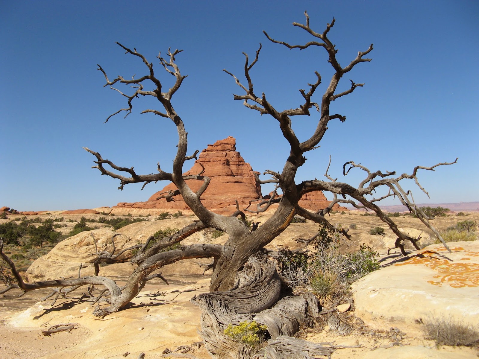
This is one of my favorites of H's dead tree photos

We parked at the end of the scenic drive, by Big Spring Canyon where our hike started.  This hike is rated fairly difficult because of the length (10.47 miles roundtrip) and the exposure - there was scarcely any shade and it got quite hot.  But the hiking itself is not difficult: we climbed up, over and down slickrock ledges and ridges, then walked across broad, sandy washes, then climbed up, over and down slickrock ledges and ridges, then across broad, sandy washes ... etc.  Although there is very little difference in elevation between the high point and the low point of the trail, we did over 1,200 feet of elevation change because of all the ups and downs.

One of the sandy washes/valleys we crossed

There was not a single step of this hike that was not gorgeous.  The washes we crossed were filled with an incredible variety of vegetation; we heard lots of birds and saw signs of snakes, lizards and badgers.  Up on the slickrock ridges, there were 360-degree views: the Abajo Mountains, the Needles themselves, Dead Horse Point.  It was just stunning, all that blue sky and green growth and red rock.

Walking along a dry streambed

After about two hours, we arrived at the Confluence Overlook, the two great rivers meeting and mingling 1,000 feet below us.

The Green River (left) coming into the Colorado River

We didn't linger too long at the overlook since it was hot and getting hotter, and we still had 5+ miles to go.  We topped off our hydration packs with the extra water we'd brought, reapplied sunscreen and headed back the way we came.  For the return trip, we had the sun in our faces and the wind at our backs, making it quite a lot hotter than the outbound leg, and for much of this leg we walked quietly and determinedly, still enjoying the scenery but wanting to get back to the truck before we ran out of water.

And the Colorado River continues on from the Confluence

Amazingly, for a well-known hike in a national park, we had the place to ourselves for nearly the whole time.  We finally ran into some other folks when we were more than halfway back to the trailhead: two day hikers, two backpackers and one odd fellow who seemed woefully under-prepared with his little liter bottle of water.

The Needles

We got back to the truck after being out for just over four hours (3:38 walking time, 2.9 m.p.h. moving average) and drove back to the Needles visitors' center.  There we found some shaded picnic tables for our beer and snacks - but no kit foxes, sadly.

More of the Needles behind a grassy wash

There were a couple of stops to make on the trip back up to Moab: to see the 1,500+ year-old petroglyphs at Newspaper Rock; and to marvel at the kitsch of the Hole N"The Rock, a kooky tourist trap sprung from a former private residence carved out of a sandstone cliff by an eccentric man.  (No photographs allowed.)  After cleaning up at the motel, we went to Woody's Tavern for cocktails before dinner at Miguel's Baja Grill (reservations strongly recommended).  We gobbled down the fresh chips and salsa, carnitas tacos (me) and the Mother Of All Burritos (H) - and once again, headed for bed early.

I like all the four-toed footprints

Wednesday, September 24, 2014

2014 long weekend in moab, pt. 2

In an attempt to get into the outside before things got really hot, we got up at 6 a.m. on Friday to load up hiking gear, biking gear and snacks.  We were in a booth at the Moab Diner for breakfast just after 6:30 a.m., watching the red cliffs on the west side of town catch the rising sunlight as we fueled up on eggs, bacon and sourdough toast.  After breakfast, our destination was Arches National Park to hike the Devils Garden trails.  We had checked at the visitors' center to see if there were any openings for the guided Fiery Furnace hike; there weren't, hence Devils Garden.

Landscape Arch

We were on the trail by 8 a.m. and could tell that it was going to be a hot one.  As we knew it would be, the trailhead was quite busy: there are a lot of arches to be seen on this hike, many of them only a short distance away from the parking area, so there are always lots of lookie-loos, especially at the start.  Tunnel Arch and Pine Tree Arch are right at the start but we skipped them, having duly noted them several times before.  Landscape Arch (0.8 miles in) was delicately spectacular as always and is the last arch on the "improved trail."  From here, the trail is "primitive," which just means it's an actual hiking trail and not a built sidewalk; the trail is not difficult but there is a little bit of slickrock scrambling and there is scarcely any shade.

Ooh! Shade!

We did the short spurs off the main trail to Partition Arch and Navajo Arch, noticing that we and three other pairs of hikers were all doing about the same pace - all the other hikers/tourists had been left behind.  Double O Arch, the larger oval looming over the smaller one, is two miles from the trailhead.  At this point, we opted to continue on the even less traveled (but still easily followed) primitive loop trail, out along Fin Canyon and through a pinyon pine-lined draw that must be full of water in the springtime.  We got back to the truck around 11:15 a.m., just in time too since H finished his water with twenty minutes of walking still to go.  As we headed out, tourists were still pouring in, many without hats and with very small water bottles.  We wished them well and hoped they weren't going to attempt too long a hike.  Hike stats: 7.72 miles, 2:45 hiking time, 3:11 total time, 2.8 m.p.h. moving average speed.

Fin Canyon. Duh.

Our next stop was Dead Horse Point State Park, to ride the new MTB trails they put in on the other side of the access road from the Intrepid trail system.  After changing into biking clothes, reapplying sunscreen (at 1,000 feet higher than Arches, it was slightly cooler but still hot and exposed) and refilling our waters, we headed out on Ravens Roll (easy), connecting to Crossroads (intermediate-easy) and Whiptail (intermediate).  These new trails are laid out nicely, through sagebrush meadows and slickrock with good flow, but I struggled in the sandy bits; every time I thought I might be able to let it roll a bit, I'd hit sand and my back tire would swerve.  I went back at the Twisted Tree/Whiptail intersection but H opted to keep going to the end of Whiptail, and found some seriously stunning views.  We met up back at the truck (A: 10.6 miles; H: 13.4 miles).  The new west-side trails are more challenging than the original Intrepid system and are a great addition to the Moab area singletrack offerings.

H riding Whiptail

After all that exertion in the day's heat, we needed some refreshments (beer and salty snacks).  We drove up into the state park a little further until we found a likely looking picnic spot with a covered table and a little juniper tree for added shade.  We were entertained for a while by a cheeky little bird (most likely a juniper titmouse) who brazenly stole our potato chip crumbs.  Then, to our great surprise and utter delight, we realized that a cute-as-a-button kit fox had decided to join the party, lounging under the juniper tree.  He was tiny - H thought that at the very most he might weigh five pounds, and probably not even that - and cat-like, and quite relaxed even with our proximity, although his giant ears never stopped moving.  After about fifteen minutes, the fox had had enough company and trotted off into the desert rocks.  It was a real treat to observe him so closely and would end up being one of my favorite parts of the whole weekend.

Cutest. Kit fox.  Ever.

The rest of the day involved going back to the motel, cleaning up, having a couple of beers on the porch/veranda, and strolling over to Main Street for a bar food dinner at Zax (friendly service, okay food, local Utah microbrews).  Then there was nothing left to do than go back to the room and crash hard.  Desert fun really takes it out of you!

And then there's the view from Whiptail

Monday, September 22, 2014

2014 long weekend in moab, pt. 1

This time the pause in between posts here was due to our most recent long weekend in Moab.  We sure do love it down there.  I think it's because it's just so different from where I grew up with the red rocks, endless skies, bone-dry air and no trees - it's like a semi-arid fairy tale world for me.  If I didn't like winter so much, I think I could be a desert rat (although Moab's summer temperatures are really too much).  We were able to drop B off at the kennel at 7 a.m. on Thursday and hit the road directly thereafter, making it to the Moab outskirts by 11.

Smooth, red Rusty Spur trail

We were on our MTBs by 11:30 a.m., riding two loops of the combined Rusty Spur and Bar M trails at the Moab Brand Trails.  Before we left SLC, I had asked H to swap out my clip-in pedals for flats, reasoning that on Moab's unfamiliar, rocky and sandy trails, I would be on and off my bike so much that flats would be quicker, not to mention less scary for not being clipped in.  I tend to ride with my left foot unclipped in the sketchy spots anyway, and I had ridden with flats for my MTB clinic last summer, so I felt like this would be a good idea.  H was skeptical - he is so comfortable on a bike that the thought of riding without being clipped in was unfathomable to him - but he swapped my pedals out for me.  The first Rusty Spur/Bar M circuit I rode with my MTB shoes, thinking that the stiffer soles would help transfer power to the pedal strokes better.  The hard soles kept slipping off the flat pedals, however, and I ended up switching shoes to light hikers for the second lap: much, much better.  My feet still slipped a bit, and I missed having the clips on the climbs, but it was workable.

Just having come over the cattle guard 
successfully on Rusty Spur

Bar M loop with the LaSal Mountains in the distance

Our two circuits gave us 19.5 miles total, with a fair amount of that climbing on the front side of the Bar M loop, so we were pleased with the ride.  We took advantage of a shady bench for our post-ride beers and snacks, finally heading into town at 3 p.m. and going straight to the Kokopelli Lodge to check in.  While H power-napped (it was a hot MTB ride, coming in around 90 F right in the middle of the day), I got cleaned up, read and had a beer on the porch outside our room, watching other tourists (almost entirely French and German) check in.  We swung by the grocery store for provisions for Friday - beer, ice and water - and then headed out for dinner, attempting Mexican at first and then ending up at our old stand-by, the Moab Brewery.  It was busy but spaces at the bar opened up for us right away.  The service was sporadic and the food surprisingly mediocre (fish tacos and a reuben sandwich), but the beers (Johnny's American IPA and the Dead Horse amber) were as tasty as always.  We walked back to the motel and crashed for an early night, done in by the afternoon's heat but looking forward to the hiking and MTBing planned for the next day.

Rehydrating in the shade

Thursday, September 18, 2014

camping, abbreviated

Unbelievably, it's been since May 2013 since we went camping.  We had hoped to go earlier this summer but got rained out; we were determined to go back to the Uintas this September.  Plus, B is getting old and a bit rickety: at age 14+ she may not have too many more opportunities to go camping and since she seemed to enjoy it in 2012, we wanted to get her up into the Uintas and fishing at least one more time.  After MTBing at Park City last Saturday, we swung by Fish Tech to re-up our fishing licenses and ask what was biting in Mirror Lake these days (red ant flies was their answer), and then spent the afternoon packing and getting organized.  When we got the truck loaded on Sunday morning it looked like we were going to be gone a week, not a couple of days.  With B settled onto the front seat between us, head on H's lap and already asleep before we'd gotten out of the driveway, we were off.

Shady Dell campsite #9

Since it was a Sunday afternoon well after Labor Day, we figured we wouldn't have too much trouble finding an available campsite.  To our surprise, Cobblerest CG was closed for the season so we ended up at Shady Dell.  There was someone just leaving the one site we were coveting, so we circled around and lurked unobtrusively until they took off.  Once in there, #9 was perfect: sunny, with trees between us and the drive to provide privacy, and just steps to a little brook.  As we set up camp, B roamed around, not quite sure of what was going on at first, and then settling down enough to dig a hole and chew on a stick or two.  She amazed both of us when, after baking in the sun for a while, she voluntarily walked into the brook and laid down to cool off - this from a dog who doesn't like to get her feet wet when the neighbors' sprinklers are running during our morning walks.

Cooling off in a Provo River tributary

We spent a lazy afternoon hanging around camp.  B can't go on long walks anymore so we just explored the nearby "Fairy Forest" a bit, read and drank some beers while the sun was still above the mountains.  As evening fell, H made a very nice fire - one match and no lighter fluid - and made us dinner: steak, onions and broccoli served over couscous.  We kept an anxious eye on the weather, especially as it clouded up right after dinner.  But once darkness set in, the clouds dissipated and the nighttime sky was spectacular with stars.  When it was time for bed, we put B in the truck and I bundled up, wearing two pairs of wool socks and my fleece gloves - the last two times I went camping, I got very cold overnight - but I needn't have worried as it didn't get nearly as cold as before (although H still commented that we were probably pushing the boundaries of a "3-season" tent).

A landlocked reef of river rocks near our campsite

Morning was gorgeous, with bright sun peeking over the mountains.  We startled a couple of mule deer and ate our breakfast of french toast, sausage and instant coffee, then loaded up to take B fishing at Mirror Lake.  We all climbed in the truck, H turned the key ... and the truck wouldn't start.  Or rather, it sluggishly started and then died.  We looked at each other in mild panic and he tried again.  This time, reluctantly, it turned over, caught and stayed running.  We looked at each other again: if the truck stopped running while we were out on the Mirror Lake Highway, twenty miles from the nearest cell signal, and with reduced hitchhike-able traffic due to it being after Labor Day, we would be completely screwed.  So we jumped back out of the still-idling truck, hurriedly packed up everything that was still out and headed back to SLC with fingers crossed.

Here comes breakfast!

We made back to our house, hastily unloaded the truck (again still-idling since we were afraid to turn it off), installed B on the couch and drove off to the mechanic, me following in my car.  We got a preliminary call from the mechanic while we were having a consolation beer at Dick 'n' Dixie's: it needs a new battery for sure, plus they were going to keep checking the other systems.  We were pretty disappointed that our camping trip was halved, and that we didn't get to take the dog fishing, but it was absolutely the right call to take the truck in rather than risk getting stranded out in the middle of the Uintas.  On the plus side, we got to have a couple of campfires and see the stars and drink beers outside in the dirt - I'll take that whenever I can get it.  And I think B was just happy to get a couple of car rides that didn't end up at the vet.

We wouldn't let her in the tent, so 
she's as close as she could get

Tuesday, September 16, 2014

trail mix

Taking advantage of the nice weather (after waiting for it to warm up out of the 40s), we decided to mix things up a little and do our Round Valley MTB ride on Saturday instead of Sunday.  We were a little leery, figuring that the trails could be super-busy, but we ended up being pleasantly surprised.  The paved bike path was pretty well-populated but the trails themselves were not.  It was a little warmer and a little drier than the previous weekend and the wind wasn't bad at all.

Grinding my way up My Nemesis.
Altho' you can't tell, this is actually a long hill.

H has been doing a lot of climbing on his road bike lately and his legs were feeling it.  He still crushes me on everything - uphills, downhills, flats - but this time he didn't pull away quite as far as he usually does.  He still managed to ride right up Hammerhead (Pladsen) Hill and looked strong doing it.  For me, my bike-handling sucked (I think I was having trouble focusing and kept letting my mind wander, which is a total no-no for me on a MTB) but I was climbing really well.  I did the best I've ever done on My Nemesis, not even having to shift all the way down for a change; rode all but three of the Sweet Sixteen switchbacks (and it should have been all but two except I - again - lost focus and put my foot down on one corner I usually ride with no problem); and made it all the way up the Staircase.  H is a good coach: before we got to the Staircase, we pulled over and he reminded me, "Remember, when you get to the car, shift down and pedal like a [redacted*]."  I did just what he said and rode right up the three rises.  And he was right there at the top, cheering me on.

Animal sightings:  hawks, buzzards (at one point, there were five of them, circling above me), songbirds, a bison and a zebra.  Yes, a zebra.  There's a small ranch on the way to the RV trails where the guy has a pet bison and a pet zebra in amongst the llamas and goats.  

*  Because this is a family-friendly blog.  But you get the gist.

Sunday, September 14, 2014

sole mio

A new Italian restaurant, Sole Mio, opened up in our town earlier this summer and, after giving it a couple of months to work the kinks out, we gave it a try.  When we first moved out here, almost five years ago, everything we tried was new to us; now, we don't branch out and try new stuff quite so much.  We need to be better about that.  It may not always work out but you're never going to know until you try.  Sole Mio didn't quite work out but at least we broke out of our rut for a bit.

Owned and run by a recently-arrived Italian family, Sole Mio (8657 S. Highland Drive, Sandy, where the Foxhole II used to be) was pretty busy when we got there a little after 7 on a Friday night, and people kept pouring in.  Although we hadn't made reservations, we were seated right away.  The large space was pretty noisy and even though we had a small table, there was a lot of "What?" going on in our dinner conversation.  Because it's Sandy, Utah, most people were not imbibing; the restaurant does have a small, serviceable wine list and a lame beer list: Bud, Bud Light, Stella Artois and one other pale, large brewery lager.  Horrified, H stuck with water and I ordered a glass of wine.  They were out of the pinot noir and I don't recall what I ended up with.  It was fine but I did have to ask for it twice.

The service is the weakest part of Sole Mio.  There were only three waiters for the whole space (plus a busboy and a water/bread girl) and they were running pretty ragged, so service was slow.  After we'd placed our order with one waiter (who seemed distracted the whole time), another one came up and introduced himself as our waiter.  When we told him we were already taken care of, he seemed surprised.  Our salad plates were never cleared when our entrees showed up.  We ended up paying cash for the bill after we watched the table next to us wait for at least ten minutes before their credit cards were picked up.

The food was fine, just okay.  We each had mixed green salads which were huge and mediocre.  H had the lasagne - again a huge portion, again nothing to write home about.  I had the spinach ravioli, which I do think was house-made, in a tomato cream sauce.  It was pretty good but wasn't served with any sort of panache: just plopped on a square plate with no garnish.

Everyone around us seemed to be enjoying themselves, however, and several tables had been back enough times that the host and waiter recognized them.  I wish Sole Mio luck but don't think we'll be back.  If we're looking for Italian food in Sandy, we'll go back to Fratelli's where the service is good, the food is better and they have Utah microbrews on tap (and serve sparkling rose by the glass!).  You know, back in our rut where we belong.

Thursday, September 11, 2014

that's more like it

Sunday turned out to be much less conflicted, weather-wise, with clear skies, bright sunshine and warmer temperatures.  We debated driving out to the Uintas to do that Lofty Lakes hike, but determined that our late start (we had to pause for bacon and eggs) wouldn't be in our best interests.  We opted for MTBing at Round Valley instead and that ended up going quite well.

It was less crowded, for one, what with it not being a three-day weekend, and less windy.  The deciduous trees are definitely beginning to change color, providing pops of pink and orange on the hillsides, making the pretty views even prettier.  We did our regular route and my legs felt strong for a change, no doubt due to the fact that I only put 3.25 miles on them on Saturday instead of 7+.  I rode the flats faster, was right behind H on the climb up My Nemesis and managed to ride all but three of the Sweet Sixteen switchbacks, including #5, which has eluded me for several weeks since the rains washed out the trails.

My word, what a nice day

Best of all, I felt strong enough to follow H back on the trails rather than taking the paved Silver Quinn bike path from the backside of Round Valley to the trailhead.  I've been wanting to do this all summer but have been waiting until I felt I had the legs - on Sunday I did and, now having seen what that section of trail is like, I feel like I can abandon the paved portion going forward.  The trails (I have no idea what we rode on, except for part of Rusty Shovel, and then we landed on trails we take on the outward bound portion of our ride, just riding them backwards and ending up at the Nouvelle [Practice] Loop) were in great shape, not washed out at all, and just rolled up and down.  The only steep section I have dubbed the Staircase - a short steep uphill section, then short and flat, then short and steep uphill, then short and flat, then short and steep uphill - and H warned me about it, telling me "when you get to the [junker] car, get in your lowest gear and then don't stop pedaling."  I followed his advice and made it to the top without problem, albeit panting a bit.

The last slog back to the truck wasn't even too bad since there wasn't really a headwind.  H did have to stop for a moment or two when a friendly off-leash dog decided he wanted to run with H rather than with his people, but aside from that it was uneventful.  I'm not about to give up hiking to spare my legs for MTBing, but this was a really good ride.  My legs are just going to have to get stronger.


Monday, September 8, 2014

curses, foiled again

Darn these mountains and their tendency to gather the weather!  No, not really: it's these mountains and their tendency to gather the weather that brings all the delicious snow in the wintertime.  But in the summertime, the mountains tend to attract thunderstorms and lightning which [obviously] impacts outdoor activities.

We had planned to do the Lofty Lake hike on Saturday; I was stoked about that because we haven't done that hike since 2010 and it's just beautiful.  But the forecast for the Uintas was a 50% chance of thunderstorms - and 50% is too high out here.  So we regrouped and thought, well, maybe we'll MTB at Round Valley instead and then do the Lofty Lakes hike on Sunday.  But the forecast for Park City was a 50% chance of thunderstorms.

So we did valley stuff - H went for a road ride and I went for a walk/run - and then, later that afternoon, considered going up to Snowbird for Oktoberfest.  But then the partly-cloudy skies over the Wasatch Front changed to all-cloudy and the breeze picked up, and I declared that Oktoberfest in the cold and rain is not that much of a party.  We threw stuff on the grill for dinner and, after checking the evening's forecast (mostly clear in SLC; clear in Provo), thought we might cruise on down to Sundance for their full moon chairlift rides.  But then we double-checked the schedule and realized that the full moon chairlift rides happen on the actual full moon - this coming Tuesday - instead of the closest weekend (when they might actually have some folks who want to ride - who's going to drive all the way out there on a Tuesday?), so we didn't do that either.

All these plans come to naught.  It was okay.  We opened all the windows to catch the cool breezes as a monster thunderstorm blew through and watched the Real Salt Lake game on t.v. (RSL won).  Some days, it just happens that way.

Friday, September 5, 2014

popular place, that alta

When Labor Day Monday rolled around, we got all leisurely, making bacon and eggs and toast for breakfast, puttering around in the cool morning sunshine with coffees, etc.  H decided that he wanted to go for a road ride so that pointed me towards my Catherine's Pass/Supreme loop up at Alta.  Because of the leisurely start to our day, I didn't get up there until close to noon ... and was amazed at the hordes of people up there.  HORDES.  I have never seen so many minivans in all my life.   Quite a lot of these people were all queued up, waiting for the shuttles to take them up to Albion Basin, but I knew the first section of trail would be busy.

Awful nice day for a hike

I pushed a really fast pace going up that first section, up through the meadow to Catherine's Pass.  I lost count but I wouldn't be surprised if I passed more than seventy people, it was just that busy.  Once on the trail to Catherine's Pass, however, the crowds thinned way, way out.  I didn't have the place to myself as I often do, but I only passed ten people, including one family who had stopped to gawk at a "badger."  It wasn't a badger.  It was a marmot, as I helpfully let them know.

Soon enough, we'll get to see this with snow on it

Up on the pass, there must have been twenty-five people sitting on the rocks and taking in the view.  I continued up the trail, past the turn off for Sunset Peak, at which point I found some solitude, not encountering anyone as I traversed the ridge over to Supreme and down to the campground.  There were no moose or mule deer to be seen on this trip; with the hordes, I imagine they'd all taken off for parts less populated.

Remains of the summer wildflowers, with 
Superior in the background

Monday evening, we took ourselves to the Cottonbottom Inn for some garlic burgers.  Eating a local Utah food after a great long holiday weekend doing local stuff outside seemed like a good way to wind things up.

Wednesday, September 3, 2014

wicked windy

Sunday morning brought bright sunshine, cool temperatures and fairly strong winds as the remains of Saturday's low pressure system moved out of the area.  We lingered at home for a bit, waiting for Park City temperatures to get up into the low 60s before loading up our MTBs and heading out Parleys Canyon.  Since we got such a late start (around 11:00 a.m.), the bike path was swarming with walkers, dog-walkers, runners and bikers but once we got out to Quinn's Trailhead, the crowds thinned out.

Heading into the Nouvelle Loop (our name for it)

It was, as I've mentioned, very windy.  We had a headwind on the paved bike path out to Quinn's, and then once we got on the dirt, the wind seemed to change direction so that we were headed into it no matter which way we went.  I felt pretty good on the bike, despite not having ridden the weekend before and even with the current trail conditions.  The recent rains have done a number on these lovely Round Valley trails, washing away a lot of that nice packed dirt and exposing the rocks underneath.  Still, I felt like I was faster than I've been, although I did have some trouble on a couple of the uphill "Sweet Sixteen" switchbacks.  The best section was the downhill Rambler switchbacks through the sagebrush: we didn't encounter any other traffic - foot, MTB or dog - until the very end, so it was easy to develop a swooping rhythm through the corners.

There was, of course, a headwind on the uphill slog back to the truck, but it wasn't as bad as I thought it was going to be.  And even though we battled the wind the whole time, H took two minutes off his usual time, finishing at 1:48, with an average speed of 11 m.p.h.

Monday, September 1, 2014

return to white pine lake

It's a cliche, of course, but time does fly and since we've been out in Utah, it seems to go by fast than ever.  Case in point: Labor Day weekend, the meteorological end of summer.  We can scarcely believe that it's September - it seems like we just got started on summertime!  Rather than sitting around and moping, however, we got out and did a hike on Saturday.  Since I have hopes that we might climb Lone Peak this fall (which is a long and arduous hike up a mountain that looms over the Salt Lake valley), I thought it would behoove us to do something a little longer, something in the ten mile range.  White Pine Lake fit the bill.

No bluebird skies today

White Pine Lake is, with the exception of the Catherine's Area loop I do through Alta, the hike we have done the most; this would be my fourth time up it and H's fifth (he did it last year without me when our friend Paul came to visit).  We didn't get a particularly early start this time and the popular trailhead was pretty full by the time we got up there, to get on trail just before 9 a.m.  The skies were a little threatening too: cloudy, with virga appearing across the valley.  Although we prefer blue-sky hiking, we figured we'd give it a go and see how far we got before the rain set in.

Lots more water than we expected

H's legs were feeling really strong and he set a brisk pace; I couldn't quite keep up with him, but managed to keep him within sight for the duration.  We passed a ton of people on the steadily-climbing old jeep road: thirteen for me and sixteen for H, because I ran out of real estate before passing the last three guys.  White Pine Lake seems slightly less popular than Red Pine Lake, I think because the round-trip is longer, although RPL is much steeper.  WPL only gets steep right as you come out of the woods and start the switchbacks through the boulder cirque.  Up at the lake itself, we were surprised at how much water was there - August's rains had done a great job filling the lake, as the lake level was easily ten feet higher than the last time I'd been up there, even with this past winter's subpar snowpack.

Teensy tiny bit of snow still up in the cliffs

We only paused for a few minutes because we were getting chilled, and on the way down the only people who passed us were a group of trail runners, bombing their way down the mountain.  With half a mile to go, it started sprinkling on us, so we timed it just right - good thing we'd been walking so fast.  We stood under the open hatchback to change out of our boots and drink our post-hike beers, watching the low clouds swirling around the canyon walls above us.

Charging up through the meadow

Hike stats:  10.48 miles round-trip; 3.0 m.p.h. moving average speed; 2,529 feet of elevation; 3 hours 29 minutes.