Friday, December 31, 2021

winter weather (part one)

 A long weekend for Christmas? Yes, please, and we drove down to Moab after work on Wednesday: there was a northern Utah storm scheduled to come in and we wanted to get over Soldier Summit while it was still dry.  This time of year, we had to do most of the drive in the dark but, for us anyway, dark roads are a lesser evil than snowy/wet roads.  When we got into town 8 p.m.ish, I was surprised to see so many cars at a number of the motels lining Main Street - this is supposed to be the off season!

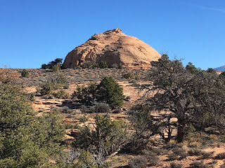
H was already on vacation but I had a couple of hours of work to get through before my time off actually begain.  After that was done, Milton and I drove up to the Sand Flats Recreation Area and parked at the radio tower for a short hike.  We went out Fins 'N Things to the Grandstaff Canyon overlook.  It was overcast and cool, but definitely warm enough whilst moving.  On our way back, we decided that we hadn't been out long enough and took some time to explore a couple of side washes, then turned left (instead of right, back the way we came in) onto FNT.  We went out a little ways, exploring more washes.  While we were poking around, a group of five side-by-sides rumbled by on the jeep road; we sat on a sandstone dome and watched them but they never even saw us.

After getting back to the car, we stopped in at the Slickrock trailhead so M could eat some breakfast and I could pound a beer.  There were around five other vehicles there: a couple of dog walkers, one MTBer with two huskies and a van-life dirt biker.  From there, we did a couple of quick errands (liquor store and City Market, both busy) before heading home to clean up.  Milton headed straight to bed when H and I strolled over to Woody's for a beer: they were going to be closed Christmas Eve and Christmas Day so we wanted to support local businesses while we could.  (We managed to support more local businesses on Xmas Eve by going to the Spitfire.)

Blurry photo #1 of the weekend

On Friday, Christmas Eve, it was again overcast when we got up.  H and I went straightway into developing our Bloody Mary recipe.  This took some time so it was late morning before Milton and I got our stuff together for a hike.  H was at that time neck-deep in a 2,000 piece jigsaw puzzle so we waved goodbye as we set off.  

It was sprinkling when we left the house.  By the time we got to the Moab Rim trailhead - I had chosen this trail because I figured it might be a little cleaner being more rock than sand - it had upgraded to light rain.  I waffled for a minute as I didn't have anything waterproof to wear: both H and I had forgotten our raincoats when packing for the trip and I hadn't been able to find my poncho.  But we were already at the trailhead and it was fairly warm (low 40s) so we went for it.  Amazingly, we weren't entirely alone out there.  There were three other vehicles in the lot when we had gotten there.  M and I met one solo hiker and then a couple with three dogs coming down as we went up the Stairmaster trail (very nice dogs and M was glad to say hi), and there was a solo guy going up the 4x4 road just ahead of us.  

I had hoped to do the Moab Rim loop at the top - out the 4x4 road to Tire-test Hill, down Sand Hill and back through the wash - but by the time we finished the climb, both the dog and I were pretty wet and I figured we'd get chilled if we kept going.  We stopped at the overlook (no view except for the very low cloud ceiling), said hello to that solo guy, and headed back down the Stairmaster.  At this point, it started raining harder: more than light rain but less than a New England soaking rain.  The coolest thing was that there were now all these ephemeral waterfalls that hadn't been there on our way up less than an hour before.  

Being completely drenched by the time we got back to the car, both Milton and I got a little chilled as I tried to dry us off a little.  Luckily, the drive back is short and we warmed up quickly once in the house.  The rain stopped a half hour after we got home.

Monday, December 27, 2021

twenty-one months

The last time I went skiing was March 8, 2020, just days before the pandemic came crashing in on us all.  

I sent H on up to Alta by himself on Saturday, in part to scope out the ski bus/Albion lodge routine and in larger part because he needed to get up there on some decent snow.  The change from two weeks ago, when the hillsides were all brown, was marked and he actually had a really good day.  The recent midweek storm (that trapped us in our house until 11 a.m. when the plow came - because the 1-3" that we were forecasted to get in the valley turned out to be 12"+) brought a couple of feet to the Cottonwood Canyon ski areas and that made all the difference.  It was cold but the snow was in great shape and he did numerous runs in Catherine's Area, scoring first tracks each time.

That's more like it

Of course everything open was entirely tracked out by the time we got there on Sunday - but the snow was still pretty good.  We hopped the bus around 7:25 (masks required) and got off at the Albion Day Lodge (since non-guests are no longer welcome at Golderminer's Daughter Lodge.  We were early enough that we grabbed a table by the window to read and put our boots on; we nabbed free cubbies in the entryway for our bootbags; we were second in line in the new singles line at the Sunnyside lift.  It's sure to get much more chaotic after Christmas but for now, a good start!

About to score some tasty pow

It was a beautiful day - cold, but warming to around 30 F by noon, and sunny.  We went directly to the Supreme chair and for our first three runs there, it was like we had it to ourselves.  It being my first day back, I stuck mainly to groomers.  H was happy to have someone (me!) to talk to in the lift lines and on the chairs, so he skied with me for most of the time, except for a run down No. 9 Express - not entirely successful as it had set up some from the day before - and when I had to go in to warm my toes for a bit.  We switched to Sugarloaf and then moved to Collins.  Things started to fall apart a bit then: the Collins lift was having mechanical or power issues and kept shutting down; the Sunnyside lift was too eventually, which took some finagling to move around the resort.  We did a run on the Wildcat lift and then made it back to Sugarloaf for some more runs.  

My ski pants still fit!

We called it quits early and jumped on the bus back down to the valley.  We'll need to do some fine-tuning of the logistics - part of why we left early was because we were hungry and Alf's no longer allows outside food - but it looks like we can make it work for ski season 2021/2022.

Friday, December 24, 2021

happy holidays

May we all enjoy the outside as much as possible in 2022!


Tuesday, December 21, 2021

desert interlude

Our first December Moab weekend was a quick one, scooting down Friday midday to avoid snowstorms (we did pass through a small squall while going over Soldiers Summit: visibility was terrible but it was short-lived) and returning Sunday (we had debated getting up early Monday and driving north then but work became pressing enough that wasn't feasible).  Short but sweet, with sunny skies, cold temperatures and a bit more snow in the LaSals.

It was cold, though.  Here's the issue with outdoor winter recreation: if you want a full day - of skiing, or hiking, or whatever - you have to get going early because the daylight doesn't last that long, and that means you have to dress for colder temperatures.  For instance, it was in the high teens on Saturday when we got up with the sun.  If you want to let things warm up - to the low 30s, for example - you have to delay your start until around 10:30 a.m., which means you just don't have much available daytime left for longer hikes.  We opted for warmer temperatures so that meant shorter hikes: more than six miles, fewer than seven.

Zephyr

We also opted for shorter drives, not wanting to waste the daylight in the car.  On Saturday, we drove to Moab Brand Trails, turning left and parking on the road rather than driving down to the main parking lot.  From there we jumped on the north portion of the North 40 trail, then connected to the Zephyr trail which, if followed to its conclusion, leads to the Klondike Bluffs trail system.  Zephyr goes out along the rim of the continuation of Sevenmile Canyon and I was hoping that we'd be able to find access to get down into the canyon. 

The trail is multi-use and easy walking.  Three MTBers passed us but we didn't see anyone else - we are finally in the off season in Moab.  We never found out if we could get down into the canyon, though, because we had to turn around at the Arches National Park boundary: you can go through (just close the gate behind you) but dogs aren't allowed on ANP trails.  It was unlikely that anyone would have caught us but we do try to be conscientious recreators.  We backtracked a little ways and then turned off onto other 4x4 roads that led us north before connecting with the Copper Ridge Road (also a 4x4 dirt road).  This jeep road runs from Moab Brand up to (at least) the Sovereign trail system, so we knew it would take us back to where we needed to be.  It did and we had hot cider (spiked with applejack, for those inclined to such things) waiting for us there.

Circle O

We had another slow start Sunday morning (H was determined to finish his new jigsaw puzzle and I was immersed in a library book) and then decided to just load up the car and do a quick hike on our way out of town.  So back to Moab Brand trails, where all three of us did the Bar M/Circle O route that Milton and I usually do when H cold-weather MTBs.  There were several vehicles in the parking lot and we saw a couple of MTBers on Bar M, but once we got out onto the Circle O slickrock, we didn't see anyone else.  Lovely.


Friday, December 17, 2021

and so it begins

I had written a whole long post about how frustrated and annoyed we are at the changes Alta has made, becoming more and more unfriendly to local skiers.  I deleted it all because we don't need that kind of negativity around here.  But yes, Alta is changing and it's really disappointing.  That being said, ski season has begun!

There's no snow in them thar hills

H missed Alta's opening day (November 24) because we were in Moab.  His first days of the 2021/2022 ski season were December 4 and 5: he drove up because (a) the UTA ski buses aren't running yet and so (b) the new pay-to-park program is not running yet.  This year I kept my pass (having cashed it in last year) but I sent H on without me so he could scope out this year's scene.  

First day selfie

Plus there's been no new snow for weeks and with a 30" base, I knew the skiing wasn't going to be that good.  When H texted me from the Wildcat base parking lot when he got there on Saturday, he said that the bowl we descended on our Emma Ridge hike earlier this year was completely bereft of snow.  In December.  That's not good.  It was busy enough that it got skied off within forty-five minutes.  He stuck it out long enough to count as a ski day and then was home by 1:30 p.m.

Did I mention no snow?

H skied Sunday too (I had actually intended to go with him, to the point of dragging out my skis and poles and boots and clothes, but ended up bailing in the end).  It was slightly less crowded and still plenty sunny but noticeably colder, with a consistent chilly wind.  He was definitely in a better mood - even a mediocre day of skiing is generally better than a day of not skiing.  As for me, I managed to move my ski gear upstairs to the mud room so now I'm poised and ready to go next time.  Hope we get some snow!


Best ski vehicles ever


Tuesday, December 14, 2021

sevenmile (not seven miles)

On Saturday, H wanted a town day: he needed a book and was hoping Back of Beyond would have some more Zane Grey.  I had been to the library just days previously (and Milton can't read) so the two of us drove north of town, turned onto Route 313 and pulled into the shockingly busy parking area just before the S-curves.  There were five other cars already there!  For Sevenmile Canyon!  I was incredulous but, as it turned out, we only saw two other people and we were on our way back out back then.

Oh that sky

Once again, it was pleasant in the sun but chilly in the shade; there was even some ice in some of the side canyons where the sun never reaches this time of year.  We worked our way up, including the side canyons - one of which brought us right underneath where'd we'd been on Thanksgiving during our Wipe Out hike - for an hour and a half, then turned around and walked out the main canyon.   This fork of Sevenmile Canyon is not as sandy as the south one but it is still challenging to walk in spots.  Soft sand is not my favorite.

Unsurprisingly, I'd had no cell service whatsoever in the canyon so I pulled over into the Moab Giants parking lot to text H that we were heading home.  We had just gotten into town when he texted me back that I should swing by Dewey's.  I did, finding a shady parking spot (although Milton, being the sun-worshiper that he is, probably would have preferred a brighter one) right out front, which I was surprised at, given how busy town was.  H and I had a beer, chatted with the bartender, and then we headed back home for a quiet night in.

Saturday, December 11, 2021

falcon flow

 Another chilly morning (and no particular rush to be anywhere on the Friday after Thanksgiving) meant that we didn't get up to the Falcon Flow trailhead at the Sand Flats Recreation Area until 10:45 a.m., for a hike on this newer MTB trail.  There were a handful of other cars there so we knew we'd need to keep an eye out for bikers; all told, we saw twenty-one MTBers so it was only barely busy.  H had ridden this trail from the upper end to this entrance but I'd never been out on it - it was clear nearly from the start that FF will be a trail I walk and not one I ride.

M hustling to catch up

It's easy hiking though, if you're not lugging your MTB along.  The trail is rubbered in pretty well so it was never super sandy, instead mainly a nice combination of packed dirt and ledges.  There is some up and down and a couple of no-fall zones (if you're on a bike) but the footing is good.

Cushy footing that

With this being our third hike in three days, we could tell Milton was slowing down a little bit, staying close to H more often than not.  At one point, when he and H were on one side of a wash and I was on the other, he (Milton) stopped to watch me, came back a few yards to check, and then, when he was sure that I was going the right direction, turned around and sprinted to catch up with H.  I guess I know where I stand in the pack - at least he came back to check on me!

Funky beehive sandstone formation

When we got back to the trailhead, it was full to overflowing with vehicles - people had definitely waited for it to warm up before hitting the trails.  We quickly surrendered our coveted parking spot and drove back to the Slickrock parking lot for beers and sandwiches.  There were lots of people (MTBers, hikers, dirt-bikers, 4x4 folks) and a couple of other trail dogs milling around too but M was too tired to do more than look on interestedly as he crunched his post-hike biscuits.


Wednesday, December 8, 2021

wipe out

Thanksgiving morning was clear and chilly so we did wait for it to warm up a bit before heading out on our hike.  We kept in mind the hordes of people from a prior T'giving attempt on Arches NP and drove right past the park entrance (big line of cars) and up to the main (upper) Navajo Rocks trailhead.  There were more vehicles/MTBers there than I expected - does nobody go over the river and through the woods to Grandmother's house for Thanksgiving anymore? 

Pretty little wash

We weren't doing the Rocky Tops loop this time, however but heading out on the jeep road that follows the cliff wall towards the Monitor and Merrimac buttes, something that I've been wanting to check out for some time.  It's no good for hiking in the summer as there is no shade and no water; and since it's a 4x4 road, it can be pretty busy in the spring and fall.  In the winter, however (and this counts as winter, I've decided), we had it all to ourselves.  Several times we thought we heard engines coming our way but it just turned out to be echoes bouncing of the red rock from miles away.

Art shot

The walking is easy: slickrock and sand, and this time of year the sand isn't too deep or loose.  We crossed several washes, heading gradually downhill (downhill the whole way out, by the way) towards the 4x4 feature called Wipe Out Hill.  This spot clearly gets a lot of action: there were lots of fences to keep the various vehicles on the trails where they belong.  We climbed up the hill, coming out right underneath the Merrimac Butte, then started our return trip just as five or six side-by-sides crested the ridge.

Feature under the butte

We found a different jeep road for the walk back, this one a straight shot across the desert meadow.  As we got back to the slickrock shelves, we started to see more folks, including lots of MTBers and a woman walking three dogs, one of them an Underdog foster puppy on her last day before her adoption.  (The puppy was very interested in Milton; Milton wasn't interested at all.)  Back at the parking lot we had sandwiches and beers while we watched the shenanigans - it seemed like half the state of Colorado was recreating in Moab this weekend, taking advantage of the nice weather.

You can't tell how steep this was

The rest of Thanksgiving was just as chill.  We made shepherd's pie for dinner, chasing it with chocolate chip cookies (H doesn't like pie and while I do, I certainly don't need to eat a whole one myself) and cheersing with sparkling rosé.  We attempted a firepit once the sun went down but it was brief on account of cold - the whole day ranged from 38-44 F - and we were happy enough to settle inside with our books for the night.

Oh, hey, a dirt road


Sunday, December 5, 2021

yet another rim trail

The Moab area, with all its canyons and mesas, has a lot of rim trails: Moab Rim, White Rim road, Porcupine Rim trail, Hellroaring Rim trail, Hunter Rim trail, etc.  When we drove down early Wednesday morning before Thanksgiving, we got to town early enough to get out for a hike by 11:15 a.m. and decided to try to find a new (to us) rim trail: up above Millcreek Canyon.  On one of Milton's and my Millcreek hikes this past summer, I'd seen a couple of folks and their dogs up on the rim, and then making their way down into the canyon in the vicinity of the cowboy hottubs, and that's what we were looking for.

Yet another dirt road

There's a sign just as you start indicating that you go straight ahead to the falls (where most people go) or turn off to the right to get up to the rim.  The trail fades out quickly, however, as you get up into the wash - we managed to find our way up there to reconnect with the trail but it certainly could benefit from a couple of cairns or a blaze or two.  Once up, we walked along an old road with Millcreek Canyon to our left and a neighborhood of newer houses to our right, nestled into the foothills.  There were a couple of flap poles here and there, including one that was marked "Yet Another Rim Trail" so we figured we were in the right place.  We kept going and when a foot trail turned off to the left, we left the jeep road and descended into the canyon.

Up on the road in the sun was pleasant but down in the shade it was chilly for sure: temperatures all long weekend would be in the mid- to low 50s and mostly sunny.  We followed the trail up looker's right side of the creek, having to pick our way through a couple of flooded spots.  This seemed a little strange until we came into a clearing and saw several big trees that had recently been felled by beavers.  We didn't actually see any of those critters but they are there and they are active.

Lots of work to fell these trees

The water is higher than it was in late summer/early fall.  This wouldn't be a problem except that it was chilly enough that we really didn't want to get our boots wet.  To head back out the canyon required five separate creek crossings of various difficulties.  Milton didn't care, splashing back and forth with glee - until he noticed H picking his way across carefully on stepping stones.  Then, very funnily, Milton would come back across the creek and then intentionally cross over stepping exactly on the stones H had just used.  He did this several times, watching H's crossing carefully so he would get it right.

Back in town, we went out for a beer.  Woody's was closed (staffing shortage: everyone had gone home early for the holiday) so we ended up at the Spitfire.  Somehow we only got charged for half our beers; we left a 100% tip so everyone came out happy about it.

Thursday, December 2, 2021

just enough time for a quick jaunt

Quick hike/quick post: On Sunday, before heading north (stupid jobs getting in the way of being in the desert), we went up to Sand Flats Recreation Area for a quick jaunt out on the Slickrock trail.  We didn't have time to do the whole Slickrock trail but managed to be out for a while, climbing up and down the sandstone swells and traipsing through the sandy patches.  There were several jeeps and side-by-sides out there right from the start, and a couple of small groups of dirtbikers; we didn't start to see too many MTBers until after 10:30 a.m. when it had warmed up a bit.

Yet another view of the LaSals from the redrock

With the warm temperatures, the snow is melting from the LaSals.  It's difficult to complain about that (although we need the snow for the water) because 60s and sunny in November is just delightful.

Monday, November 29, 2021

trotting turkeys

 Running Thanksgiving turkey trots used to be my thing.  I mean, not really, because I'm not much of a runner.  But for several of our last years in Maine, H and I would do Portland's Thanksgiving morning 4 miler with a bunch of friends (and then, per tradition, go for morning beers to prep for the rest of the day's festivities).  When we moved to Salt Lake City, one of the first things I did was find a Thanksgiving morning run (the Cold Turkey 6k).  I think this is a great race and ended up doing it nine times.  The first two we were even able to find a bar that was open early enough on Thanksgiving for us to have morning beers to prep for the rest of the day's activities; after that place closed, I just cracked my morning beer at home.  But 2018 was the last time we spent Thanksgiving in SLC and so I haven't done a turkey trot since then.  Until this year, when the weekend before we saw that Moab had a pre-Thanksgiving 5k and both of us decided to sign up for it, totally on a whim.

Medalists! lol

It was partly cloudy and in the 50s on the morning of the race as we drove over to the Aquatics Center (which is an amazing facility: indoor and outdoor pools, fitness center with weights and cardio machines, locker rooms and showers for purchase if you've been out camping in the desert for too many days in a row) for the start.  This is a very local race: only about sixty people this year (they had around 100 in 2019).  The route went south on 100 West, on the trail through the woods and past the bike skills park, north on 500 West to 400 North, through the grade school, back to 100 West and around Swanny Park to the finish line - absolutely the flattest road race I have ever done.  They did a little kids 1k around the park and then we were off.

Not bad for not having run
at all since 2018

It was a great little race, with the perfect temperatures.  My only goal was to not walk - it's been a long time since I actually ran.  I met my goal, plus was not passed by any women and came in second in my age group!  H, who hasn't run since 2018, also came in second in his age group.  The guy who beat him also took home the prize for first dog (on leash) across the finish line ... you better believe that we're doing this again next year, and with Milton!

Total turkey


Friday, November 26, 2021

in which we discover who is milton's favorite

On a recent long weekend in Moab, the three of us went out to the Moab Brand trails.  It was a gorgeous but chilly morning and since we had the Subaru (with no bike rack), H was going to MTB while the dog and I walked.  As soon as we pulled into the lot, Milton and I headed out for our usual winter walk loop: the parking lot cutoff over Copper Ridge, then right onto Bar M to Circle O.  H's route was the front side of Lazy EZ, to Rusty Sput, to Bar M and then right out to the Arches NP overlook on the Bar B doubletrack, back on the doubletrack and north on Bar M, cutoff to the back half of Lazy EZ, right onto the parking lot cutoff and left onto Bar M and then out onto Circle O to try to meet us.

Sun's out, tongues out

These diverging routes were good because whenever Milton sees H on his MTB, he wants to go with him: I have to keep him on the leash - and he pulls SO HARD - until he's distracted by a bird or a lizard or a rabbit and forgets that he wants to catch H.

We saw three MTBers out on Circle O. Milt takes a good look and then, once he's determined they're not H, keeps on doing what he's doing.  We found several potholes still full of water from rain earlier in the week and he plunged right in, drinking and wading and ducking his head under the water.

As we were finishing up at the last and biggest pothole (with maybe a quarter of the Circle O trail left to do?), H texted me, asking if we were still out there.  He'd come out to a tricky section and didn't feel like hike-a-biking, so he said he'd turn around there and keep going to finish the Bar M loop.  About thirty seconds later, Milton and I crested a rise to where we could see H, about a quarter-mile away.  Milton stopped and stared for several seconds, long enough for him to decide that the MTBer in the distance was, in fact, H.  And then that darn dog took off, faster than I could call him back (and I don't know if he would have paid attention to me anyway), sprinting to chase H down, hurtling over rocks and gaps and cacti.  I quickly texted H:  He sees you.  He's coming.  And then just moments later, H texted me back: He found me - I'll keep him.  And just like that, I'd been abandoned by my dog.

Almost deep enough to swim

We all got back to the car at the same time: I could see them coming down the road, H going slower than his normal speed and Milton locked into his ground-eating fast trot, trying to keep just ahead of the bike.  He was quite tired but rallied enough for biscuits and to make friends with some of the other dogs hanging around in the parking (mixes Freddie, Fonzie and Goldie next to us; and also griffon Annie and the very cute Australian cattledog Toast).

Tuesday, November 23, 2021

return to olympus

 A couple of Sundays ago, when Milton and I had gotten back from our 3.5 mile Dimple Dell walk, H said, "You wanna go do something?"  Unless it's pouring rain, I usually do want to go do something (and Milt is always up for anything), so that's how we ended up hiking Mt. Olympus again 10.5 years after we did it the first time.

The city is right there

Make no mistake: this is a hard hike (you can hit the link above for a more detail hike description).  On the way up it is all up, very steeply in spots, averaging over 1,000 feet of elevation per mile.  From the newly revamped trailhead - when we were there in 2010, it was a small dirt lot; now it is paved, one-way traffic only, with a (pretty filthy) restroom, and they are working on improving the start of the trail - it is steep and loose underfoot.  Then there are broad, sweeping switchbacks up to the Bonneville Shoreline Trail.  It's not too bad from there to the Tolcat Canyon spring, although it is still clearly going up, but after the creek crossing the switchbacks get much steeper.  At the second (dry, at this point) creek crossing, the switchbacks just disappear and the trail goes straight up the drainage.  It's rocky too, for more fun.

On alert

As Milton and H ground on ahead of me, I started to struggle right around the Tolcat creek and then I really slowed up after the second creek, with an odd combination of sweating like crazy coupled with cold hands.  It was in the low 50s, with in and out sunshine, so the weather conditions were decent.  My fingers just tend to shut down when it's in the 50s.

View towards the Cottonwood Canyons

There was a group of young women having snacks at the saddle.  They really liked Milton and one asked if he'd been named after the English poet, John Milton; there was a lot of laughter when we explained he was actually named after a burger joint.

Resting up

We didn't attempt the summit like we'd done in 2010: the last 600 feet are scrambling and a bit technical, not ideal for dogs.  So after some snacks and layering up, we started back down.  My knees were twingeing so I took a couple of elderly Motrin from our first aid kit (note to self: update first aid kit) and those definitely helped and the descent was much faster than the climb up.

The valley filled up for just a few minutes

Because Mt. Olympus is basically an urban trail (and SLC has gotten so populous), we saw lots more people than we often do on our hikes: trail runners, groups of all sizes, folks with dogs.  Still, because it wasn't all that nice a day, traffic was likely less than it is on pretty spring mornings.  It's funny that so many people hike this trail because it is just so dang steep and such a grind; I think a lot of people just go up to the Tolcat spring and call it good.  It was even steep for Milton - you could tell he was tired by how close he stuck to H.

Beer!

For apres, we dropped by the Hog Wallow - which, funnily enough, is exactly what we'd done in 2010.  We split a pitch, inhaled a basket of fries and, as our quads slowly tightened up on us, wondered if it would be another ten and a half years before we hike Olympus again.  (That puts us in spring of 2032, in case you're wondering.  Check back then.)


Hike stats: 6.32 miles (plus Milton and I had already done 3.5 before the hike even started); 3.1 hours/2.0 m.p.h. moving; 4.02/1.6 overall (so slow!); 3,580' elevation

Saturday, November 20, 2021

wrap up

Last day, there was enough time to drive up towards Sand Flats for a quick 2.5 mile walk out to the Millcreek Canyon overlook.  There were several other cars parked at the pull-out but we only saw one family of three plus dog right at the start, so we had it to ourselves.  Out at the overlook, we stayed for a little while, watching ravens barrel-rolling overhead, offering play-by-play commentary to the three jeeps attempting Potato Salad Hill and waving to the hikers down in Millcreek Canyon.

The creek in the sun looks like a path 

It was just a short walk, enough to stretch our legs a bit in the sunshine before the drive north to SLC.  I don't care how many times we go to Moab: we're always sad when we have to leave.  

Wednesday, November 17, 2021

river walk

 Saturday wasn't the nicest day - cool to start, then warmed up a little; cloudy for most of the day - so we decided to do a family town walk and did pretty much the whole paved bike path in Moab, and then some.  We started out by Rotary Park, took the tunnel under 400 East, moseyed over the creek a couple of times and under Main Street.  Continuing north along 100 West, we passed Swanny Park and picked up the most recent segment of the bike path, crossing 191 by Lin Ottinger's Rock Shop.  We crossed back over to the west side of 191 just a little further on because we wanted to check out a gate and a kiosk just north of the Aarchway Inn: it's an entrance into the Matheson Wetlands Preserve.  We didn't go in, though, because no dogs allowed; there also don't seem to be any trails at this northern end although the southern end does.

We kept going north on the sidewalk and were delighted to discover that there's a pedestrian walkway under 191 to the Lions Park.  From here, we took the foot bridge across the Colorado River, pausing to check out how low the river was at the town put-in, then kept going upriver along an unsigned trail.  It was clear that lots of people have gone in here but we didn't see anyone on our way in.  We didn't have a goal in mind - we just wanted to see how far we'd get.  The trail goes between the cliffs and the river, through flood sections and tamarisk groves (yuck tamarisk).  When we found a little sign saying that we were crossing into Arches National Park, we stopped because no dogs allowed.  The trail kept going, however, and we were curious to come back sometime without Milt to see just how far it continues.  I can't imagine it goes too far as the cliffs come right down to the riverbanks, but it would be fun to see.

So we retraced our steps and then went south on the paved path alongside 191.  At this point, it was late enough in the day that MTBers started passing us on their way back to town from the Whole Enchilada.  We crossed 191 at Ottinger's again and when we got to the Spitfire, the beers just called our name.  While Milton loves going on walks, this may have been his favorite part of the whole day: making friends with a group of millenials from New York and charming several MTBers.

You can see why Milton likes going to bars

By the time we got home, we'd done 10.23 miles - not too shabby for a stroll about town.

Sunday, November 14, 2021

back to pipe dream

We've hiked Pipe Dream a number of times, in various iterations, but we've never MTBed it.  It doesn't have the notoriety or glamor of many of the other well-known Moab area rides, like the Whole Enchilada, Slickrock, Mag 7 or Captain Ahab, but it is deceptively difficult for a little trail that runs at the bottom of the cliffs, rather than along the top of them.  I've hiked it enough to know that it's too tough for me to attempt on a MTB; H wanted to try it.

Trail dog

The recommended way to ride Pipe Dream is south to north (apparently north-to-south doesn't flow at all) so he set off on his MTB, riding south on 191 to the Hidden Valley trailhead.  That road portion is not particularly pleasant this time of year: too much traffic, too many trucks.  And then it's a climb up to the trailhead so by the time he got to the start of the trail, cumulative fatigue from the days prior was already kicking in.  The whole trail is singletrack and starts with a climb from the parking lot.  From there it's up and down on sometimes very narrow singletrack, with technical switchbacks, chunky sections and some sideslope stretches that are no-fall zones.  It's not that it's cliffy but that the downhill falls away immediately from the trail and there's just nowhere to put your foot down.

Such a good photo subject

H rode it to the Jackson Street entrance/exit and got out there (8.56 miles), having walked more of the technical bits than he would have liked.  We both ride with clipped-in pedals and while H vastly prefers those to flat pedals, he conceded that he might have had more confidence to ride the trickier bits if he knew he could just put his foot down without hesitation if he needed to.  I could tell that he was already thinking about the next time he'd give Pipe Dream a try.

"Imma need a minute"

While all this was going on, Milton and I were also on Pipe Dream: we walked to the Jackson Street entrance and did the north part from there as an out and back.  I could tell that even the dog was getting cumulative fatigue as he stuck to the trail fairly near me, only running off after some critter once or twice.

Thursday, November 11, 2021

back to hidden valley-moab rim

The first time we did this hike (June 2020), we didn't take Milton.  We weren't sure quite how long it was or how hot it would get.  This time, we knew we could do it in just over ten miles (10.05 actually) and, being well into the fall, we knew he wouldn't get overheated.  Without getting too much of an early start, we set out from the house, getting onto the Pipedream trail via the Jackson entrance and walking south towards the Hidden Valley trailhead.

Moody morning

There were a number of cars at the HV trailhead and we passed a couple of groups of hikers (including a very friendly golden retriever) as we ascended the cliff and walked up the valley.  After pausing at the saddle to tell some folks how to find the petroglyphs, we descended the other side and headed down towards the Moab Rim trail.  Milton had stuck pretty close to H until this point; now he started ranging widely, chasing after whatever critters he thought he was sniffing.  

"I think that was a rabbit"

When we got to Sand Hill, we had a choice: go down the hill and through the wash or continue on the main trail on the rock, up and over Tire Test Hill.  We knew that it would be slightly shorter through the wash so we went that way, knowing that Milton's miles were adding up rapidly.  We also suspected that there might be water in the wash after the rain the night before.  Sure enough, there were a number of full puddles and potholes for Milt to splash into and drink from.

As we walk through the valley

There wasn't much action on the Moab Rim trail while we were hiking out on it.  We were a little disappointed but once we got to the truck (as before, H had driven it over and ridden his bike back in the morning) for our post-hike beers, the entertainment commenced.  We watched a group of six or seven jeeps deflate their tires and then head up the trail, easily handling the Devil's Crack and Z Corner obstacles; shortly thereafter, a side-by-side followed them up and then passed them after the Z Corner.  We also saw five or six MTBers coming down the Portal Trail across the river - and we applauded them for it.  That trail is not for the faint of heart (or wobbly of bike-handling).

Milton on the Moab Rim trail

Milton was so tired that afternoon that we didn't even have to sneak out to go for a beer at Woody's.

Taking in the river views


Monday, November 8, 2021

split decisions

At this point, H was hankering for a road ride (we'd finally been clever enough to realize that even with the two MTBs on the bike rack, we could put his road bike in the bed of the truck).  Moab has recently finished all the connectors of the paved bike path so you can ride - off the street - from Rotary Park to Route 313.  So once things dried up after the overnight rain, he rode 21.02 miles.  

Cute little cacti

Milton and I are not road cyclists so we walked to the Jackson Street trailhead for the Pipedream Trail.  We went north-to-south (opposite of the recommended MTBing direction), hiking from the Jackson entry to the Hidden Valley trailhead and back again.  Milt is actually very good about staying on singletrack trails UNLESS he sees a critter (squirrel, rabbit) and then all bets are off.  I did about eight miles, including the walks home/trailhead and trailhead/home, but I would imagine that the dog did around twelve.  He is impressively fit for being a weekend warrior.

The next day was clear and rather cold in the morning.  The three of us did a 4+ mile town walk on the Millcreek parkway.  Then we packed up sandwiches, beers and books and books and drove up to the Slickrock trailhead parking lot at the Sand Flats.  We set up camp in the middle of the parking lot and enjoyed the afternoon sunshine.  Milton also enjoyed a fair amount of attention as a cute dirtbike chick and a couple of MTB dudes came over to give him some pets.


Friday, November 5, 2021

back to porcupine rim

A cold front moved in on Monday: increasing clouds throughout the day and rain at night.  Thinking that there might not be too many MTBers coming off the Whole Enchilada on a Monday, we took Milton out the river road to hike up the Porcupine Rim.  While we certainly didn't see as many bikers as we would have on a weekend, we still saw 30+.  It wasn't so bad as we hiked out as it was earlyish and, since we were hiking uphill, we could easily see any MTBs heading down towards us.  

Looking up Jackass Canyon

It was a little trickier once we turned around and retraced our steps:  it was later in the day so there were more riders and we were facing downhill, the same way they were riding, so we had to keep looking over our shoulders so as to keep out of people's way.  There was only one time that a couple of girls came up on us without us realizing it ahead of time and for the most part, MTBers are pretty chill.  When we finished up (6.78 miles) , exiting through the tunnel under the river road, there was a group of riders rehashing their ride.  When we asked how it went, they were all grinning ear to ear, super-stoked.

You can see everything (and there's nothing there)

When you're not having to dodge MTBers (i.e., winter), this is a great trail to hike.  It's gnarly but not so gnarly that bikes can't get down it.  It gains elevation quickly so the views - of the Colorado River and of Jackass Canyon - show up fast.  We just happened to turn around where we wanted to but if you're in mind for a longer hike, you can just keep going up and it will eventually intersect with the Sand Flats Road - ideal if you've got two cars and want to do a shuttle.

Above the Colorado River

Monday's search for Crystal:  We went to the Blu Pig and managed to catch up with her before it got too busy.  She'd had a great West Virginia rafting trip - big water - and had already planned to go back again next October.