Monday, June 29, 2015

desolation lake to butler fork

It is hot in northern Utah right now.  Like we're having a heatwave hot.  This means that people who want to do stuff outside need to make adjustments, like going extra early or extra late.  We're early people.  It's not my natural tendency but when I know we're going to go do something, I can get up and get going.  When we decided to hike to Desolation Lake on Saturday, we decided to make it a little longer by coming down through Butler Fork, rather than just retracing our steps down Mill D.  We weren't sure exactly how long this would be but we knew we needed to get going fairly early so that we could finish and be out of the sun before it really started to bake.

Mule deer doe, watching but not worried

We got up at 6 a.m., leaving the house around 6:30 a.m. or so.  As we drove up Big Cottonwood Canyon, we were amazed/impressed to see other hikers already parked at the various trailheads; clearly we weren't the only people trying to beat the heat.  We parked at the Butler Fork trailhead and continued walking up the road, heading for Mill D.  The temperature was very pleasant, cool even, and there were lots of folks out taking advantage, including runners, road cyclists and moose - we caught a glimpse of a mother and her twins heading deeper into the forest from the Big Cottonwood Canyon creek.

Columbine

No matter how often we hike this trail - and it's fairly often because it's pretty and a good workout - I forget how tough it is in spots.  It starts pretty steeply from the trailhead until it gets up onto a bench, then continuing more gradually along the drainage under the aspens.  From the Dog Lake/Desolation Lake junction, it gets steep again but the trail underfoot is packed dirt, pleasant to walk on, and it is shaded, which is a bonus.  After climbing for a while it finally flattens out for a stretch of what H calls possibly his favorite stretch of hiking trail ever.  The trail stays in the trees but follows a field up the valley; we saw a mule deer doe on the other side of the creek and she was completely unconcerned with our presence.

Desolation Lake

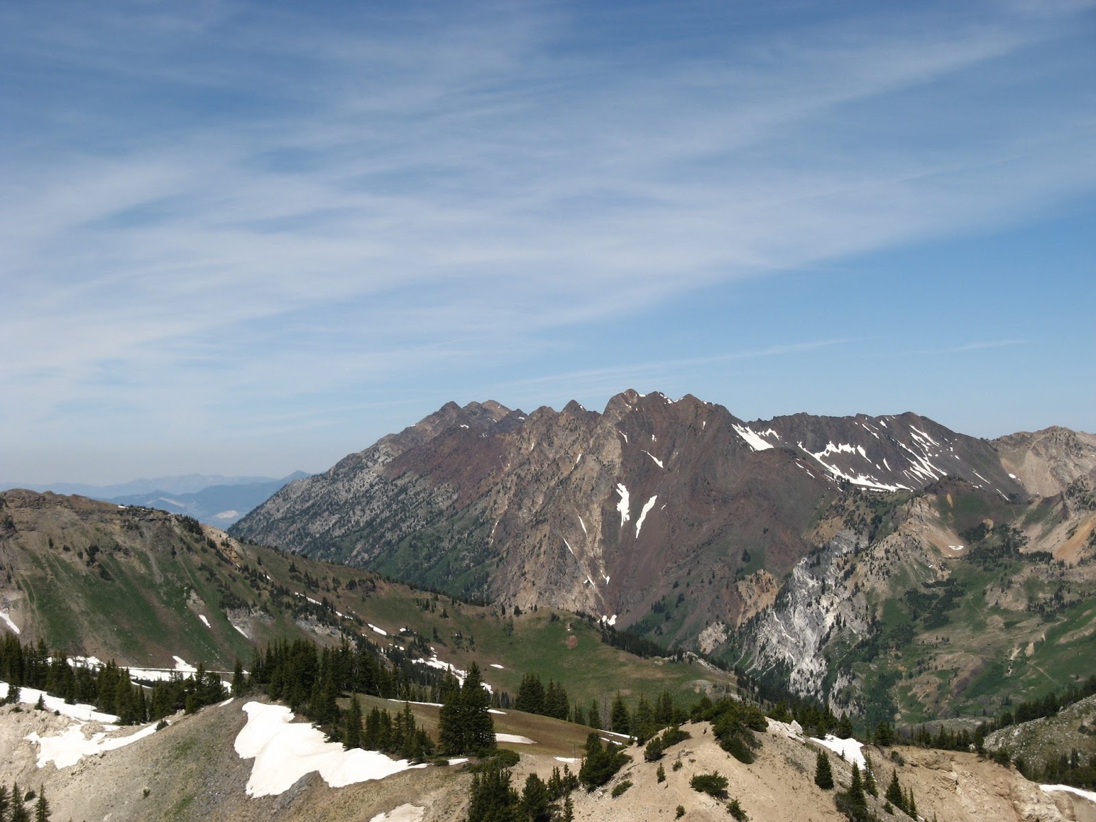
It gets a little steeper just before the lake - which is just so pretty, a turquoise color surrounded by the green hills - and then, as we continued past the lake towards the Wasatch Crest Trail on the ridge, it gets steeper still, the long switchbacks helping to eat up elevation.  The wildflowers are really ramping up now and we walked through hillsides covered with them:  paintbrush, buttercups, columbine, wild roses, sticky geranium, bluebells, fireweed, penstemon and lupine.  We reached the Wasatch Crest Trail and walked just a bit further up until we could see over the back side, down into Canyons Resort.  This is a view we don't often get and it was interesting to see Park City from that angle.

Canyons

To get to Butler Fork, we had to retrace our steps all the way back down to the Dog Lake/Desolation Lake junction and then hike up to Dog Lake.  I know people like that hike - it is very popular with novice hikers (who do not know trail etiquette) because it is not too long - but it is a steep, sweaty, miserable grind straight up the drainage to the lake.  Not my favorite.  We didn't linger there but continued up past the lake to the left to the Butler Fork trail.  This trail is not nearly as heavily used as Dog Lake/Desolation Lake and, as we headed down the drainage, it was quite overgrown with the early summer vegetation well over my head in places.  At one point, just as H passed an aspen grove, a young mule deer buck jumped to its feet, startled out of its resting place.  If that deer hadn't stood up, we would have walked right by, never knowing it was there, hidden by all the greenery.

So green!

We finished the last, steep and rocky bit of the Butler Fork trail just as H drank the last of his water - just in time.  It was unshaded by the truck and we were hot and sweaty but still were able to manage a beer as we changed out of our hiking gear.  This was a long hike but due to the early start, the mostly-shaded trail and the finish down through upper Butler Fork, we were able to stay out for a long time without seeing too many people.  It was a pretty good critter haul too: the moose, the mule deer, hummingbirds, a small snake and scores of potguts, chipmunks and squirrels.

Perilous stream crossing

Hike stats:  11.32 miles; 2,900 feet elevation gain; total hike time 4:36; moving hike time 3:45.


Friday, June 26, 2015

pcmr: park city mountain resort

Sunday morning it was determined to be important that we go out to breakfast.  H and I had planned on Ruth's Diner, since that's always such a great place to take visitors.  We had completely forgotten that it was Father's Day, however, and our jaws dropped when we rolled up at 8:30 a.m. to see a completely full parking lot and what looked like a 45+ minute wait.  R and I needed coffee too badly to suffer that line so we drove back into town, sitting down right away at The Other Place.  It wasn't as scenic as what we had planned but we all got plenty to eat, they kept our coffee mugs filled and we were in and out in less time than it would have taken for us to get seated at Ruth's.

Father's Day call from the kids

After breakfast, we drove back through Emigration Canyon, taking the scenic route to Park City and ending up on the Jeremy Ranch road.  We were hoping for moose in the creek but were out of luck on the large animal front, not even getting any range cattle standing in the middle of the road.  We continued into Park City, pulling into the lot at Park City Mountain Resort.  The plan was to do a modification of a hike we'd done back in 2012:  we were getting a late start and the sun was strong, so we just wanted enough to stretch our legs and perhaps earn a beer or two.

Getting into summer means getting under this hat

We started on the Spiro Trail - which has undergone a LOT of work by local trail crews and is in great shape - which brought us to Eagle and Crescent Mine Grade.  Instead of grinding away on the sunny ridge, we stayed on CMG which was mostly shaded and which brought us back down to the center of the resort. 

Park City Mountain Resort

There were lots more wildflowers in bloom here on the Park City side, including gentians and columbines, both of which aren't even close to flowering yet in the Cottonwood Canyons.  There were also lots of MTBers on the trails; we always stepped off the trail to let them by, no matter who was going uphill/downhill, and 99% of them were friendly and cheerful about sharing the trails - as everyone should be, because who could be cranky being outside on such a beautiful day?!

Hike stats:  4.09 miles, 900 feet of elevation gain, 1:33 moving time

Tuesday, June 23, 2015

bringing the heat

This weekend brought the official start of summer - complete with seriously hot temperatures, nearly ten degrees above normal in the mid- to high 90s range - and also our good friend R.  He had a work thing scheduled in Salt Lake City and asked if he could come out early to do some hiking with us.  The last time he'd come out was in 2011 and the last time we've seen him was 2012, when we had Thanksgiving with him and his family.  We picked him up at the airport and had dinner at Squatter's (no Full Suspension on tap - scandalous!), then went home and stayed up far too late talking and catching up, as we always seem to do when guests come to visit.

R and A on Catherine's Pass

There was some debate Saturday morning about what we should hike.  H was adamant about not going back to Millcreek Canyon since we've been hiking it so much lately.  I wanted to make sure that we did a long enough hike that R didn't feel like we were taking it easy on him, coming right from sea level and all.  We decided to do my beloved Catherine's Loop, figuring it was a good, medium length hike with some (but not too many) steep spots and fantastic views.  H suggested that we throw in the Sunset Peak spur, R and I were game and we were off.

H and R with Lake Catherine behind them

We parked above the Albion lodge in bright sunshine over the very green mountains.  The gate across the Summer Road is still closed - it will likely open in July when the campground opens - so we began our hike from there, grinding up the Sunnyside bunny slope, cutting back on the Summer Road and then heading up the trail to Catherine's Pass. It wasn't long before we got to some snow, lingering in patches in the shadier spots and then, as the elevation mounted, even across the sunny fields.  We didn't see any moose (although we were hopeful of it), just a bunch of potguts, a couple of marmots and a small herd of campfire-scented Boy Scouts, heading home after a couple of nights camping out.

View of Superior from Sunset

There were a few people up on Catherine's Pass but when we summited Sunset Peak, we had it to ourselves.  We continued along the loop, crossing the top of the in-bounds Catherine's Area on top of snow and then continuing down the access road to the campground.  The wildflowers are just beginning to come out in the meadows, sunflowers, early lupine and sticky geranium mostly.

Making our way across Catherine's Area

We briefly thought about going up to Cecret Lake before returning to the base, eventually deciding against it because of the up involved.  Cold beers and snacks were waiting for us at the truck and we felt like we'd earned them.  It was pretty warm there in the sunshine, warm for Alta anyway, and it was be much, much warmer back down in the valley when we got home.  There was some discussion about whether we should go back up Little Cottonwood Canyon for Snowbird's first Cool Air Concert of the summer but the lure of central air, a fridge full of beer and televised soccer games proved too seductive for us to resist.

This map is kind of fun, with Alta's ski trails and lifts listed

Hike stats:  7.84 miles; 2,000 feet elevation gain; 3:16 walking time, 4:01 total trip time.

Friday, June 19, 2015

the secret to my success

H washed our MTBs after the rather muddy ride we did the previous weekend and in doing so, discovered that my rear tire had a small slice in it.  Whatever had cut the tire hadn't gone through to puncture the tube, but it was a big enough cut to merit a new tire.  When we went to the bike shop, they handed us a tire, then asked where we we rode, then handed us a different tire with "more aggressive treads," saying that if we were just riding in Corner Canyon (Draper), the first one would have been fine.  We went home, H put the new tire on my rear wheel and we were good to go.

Mo' treads, mo' better
(H's worn tire on the left for comparison)

Back at Round Valley on Sunday, it was evident that summer had arrived.  The squishy spots had all dried up and the trails actually seemed to be in pretty good shape and not too torn up from people riding in the wet.  The dry trails also meant that we could get back to our preferred loop.  Part of what I like about our loop is that we've got the climbs spaced out fairly evenly:  Hammerhead Hill comes close after My Nemesis but since I have to hike-a-bike Hammerhead, that doesn't matter much to me; then there's some nice, rolling double- and single-track before the Sweet Sixteen climbs; then more flow until the Staircase, which is steep but short.

Apparently there was some sunscreen on
the camera lens.  I think it's Impressionistic.

My legs were a little stiff from the Mt. Aire hike but I seemed to be climbing pretty well.  I was pleased with my performance on Sweet Sixteen, riding fourteen out of sixteen switchbacks including one that has stymied me thus far this season (I shout-whispered, "Yes!" when I got around that one.)  It wasn't until the Staircase, however, that I realized how great my new tire was.  I've been able to ride the Staircase on prior rides although my rear wheel has usually spun out in the steeper pitches.  This time, I could feel those "more aggressive treads" bit right into the dirt and was amazed at how much easier the climb was.  I was actually grinning at H when I got to the top (in addition to the gasping for air).  New treads make a huge difference - I highly recommend them.

Sunday, June 14, 2015

who keeps picking the steep ones

H came up with steep ol' Porter Fork a couple of weekends ago but this Saturday, the precipitous Mt. Aire was my selection.  I hadn't hiked it since 2010 and it's been since 2011 for H (who did it when our friend Paul came for a visit); I couldn't recall the trail very well, except for remembering that it went up alongside a creek and was thus a little humid, at least for out here in the high desert.  We got an early-ish start (we'll have to start earlier from here on out, however, because it's going to start to get hot), nabbing one of the last remaining parking spots at the lot next to the gate five miles up Millcreek Canyon at about 8:15 a.m.

H at the saddle

With all those cars so early, we were sure that the trails would be inundated with people, but once again, we got lucky: three trail runners exited the Mt. Aire trail just as we headed up and one trail runner with two dogs went up ahead of us, but that was it.  Maybe it wasn't luck, however, but other people having better sense than we do, because Mt. Aire is a steep little bugger of a trail, grinding straight up the drainage (alongside a lovely little stream which was (a) humid for us but (b) great for thirsty dogs) with nary a switchback.  Despite its steepness, it's a nice trail, mostly shaded and packed dirt underfoot.

View to the east from the Mt. Aire summit

We came out of the shady trees at a sunflower-studded saddle and then turned east up switchbacks to the summit.  This section of trail is rocky underfoot and less shady, with only gambel oaks and junipers at that elevation, and while there were long switchbacks crisscrossing the hillside, it still gained elevation quickly.  We met up with the two-dog trail runner at the top, just as they were heading back down.  H asked him how his run was and he laughed, confessing that due to the steepness of the trail, it had really been more of a hike.

Where's the snacks?

At the summit, we climbed out on the ridge another 200 yards or so and perched there to eat our snacks.  There was a light, cool breeze, very pleasant and enough to keep the flies away, and we had the place to ourselves with a 360 degree view.  An early forecast had threatened midday thunderstorms but that had later been recanted and we enjoyed our trail mix, beef jerky and granola bars under cloudless skies.

View to the northeast-ish

I was slipping on the loose rock on the first part of the descent but once we got below the saddle, we were back on that lovely packed dirt trail and we cruised back down.  We ran into a few other hikers who were on their way up - and also a young moose, shy enough not to stick around for long - but the trail was still pretty quiet for busy Millcreek Canyon.  Things picked up a bit as we walked down the road from the trail head back to the car, and as we drove out of the canyon, the lower picnic and parking areas were full to bursting, but once again we were thrilled to have found some peace and quiet along the Wasatch Front.

The moose is loose

Hike stats:  6.75 miles RT; 3 hours 20 minutes trip total (2 hrs. 32 min. hiking); 2,300 feet of elevation gain.


Wednesday, June 10, 2015

mud is murder

We got a fun thunderstorm Saturday evening, rolling in with lots of lightning and a decent amount of rain.  The storm didn't last all that long before it moved off east but it left enough water behind that we were concerned about the state of Round Valley's trails for MTBing.  Mud is murder on trails.  We conscientiously checked the trail conditions website when we got up Sunday morning but here's where the system breaks down.  There's no time stamp on the conditions map so there's no way of knowing when it was last updated.  When we checked it last weekend, it said that Round Valley's trails were "variable" when in fact they were dry since it had been several days since it had rained.  When we checked this past Sunday, the report said Round Valley was dry when it had just rained the night before.

When we got out there, it was quickly evident that the trails weren't dry.  The double-track and jeep roads were soft-ish but rideable; the singletrack was very soft and muddy and while we could ride portions of it, we were hopping off and on our MTBs a lot to walk around the mud.  Not fun.  (Also: a big boo-hiss to the jerky persons who were out there riding through the mud and the puddles and tearing up the nice trails.)  We managed to do our regular loop all the way to riding up My Nemesis but from there we re-routed, staying on the double-track until we could get off the dirt near the Park City ice rink.

That's a trashcan behind me, not a 
lumpy backpack on my back

From there, we headed out towards the far end of the paved bike path, taking the newly installed tunnel under the highway to see where it led.  I had hoped it would bring us to some more MTB trails - no such luck, so we looped back along the frontage road until we were back at Quinn's Trailhead, and then continued back on the paved rail-trail.  We kept going past the truck, however, at H's suggestion that we ride all the way into Park City to see what was going on at the summer's first Park Silly.  What was going on was a full-on party as the closed-off streets were swarming with people and dogs.  We left our MTBs with the free bike valet (thanks, Cole Sports!) and walked up and down the street fair on a churro hunt (no luck).  A cover band was rocking ZZ Top tunes and the only booth with a longer line than the garnish-your-own-Bloody-Mary stand was the fruit-smoothie-in-a-hollowed-out-pineapple stand.  We didn't partake but both of those options looked delicious.  There was also a Maine lobster roll food truck, selling $22.00 lobster rolls (lobster overnighted from the wharfs in Portland, Maine) and real Maine "red snapper" hot dogs.  Awesome.

More pavement this weekend

After cruising the scene we retrieved our MTBs and rode back to the truck.  We ended up with 19.2 miles on the day, slightly less than our usual 20.8 mile loop, but still respectable given the ad-libbed route-finding we were doing.

Sunday, June 7, 2015

crack of dawn, part 4

Remember how last year I said that I wasn't sure if sacrificing so much of a precious weekend for the recovery after the Crack of Dawn 8k was worth it?  I apparently learn nothing and signed up for the race again: Saturday, 6:30 a.m. start, 8 k.m. downhill from the closure of Millcreek Canyon to the Olympic Hills shopping center on Wasatch Boulevard.  They're still tweaking the race a bit - 6:30 a.m. start again this year; finish uphill in the shopping center like in 2012/2011 - but the concept remains the same.  This is a low-key, early morning, fun race, mostly populated by women, that appearing to be growing (slightly) in popularity each year.

This is uphill, actually.  Trust me.

H dropped me off at the start in cool temperatures and under a slowly brightening sky.  This year I had someone to run with: my work neighbor N, fifteen years younger than me and a Ragnar aficionado.  She has the Drop 13 half marathon down Big Cottonwood Canyon coming up and then the Wasatch Back Ragnar, so she was going to use this little race as training; she prefers running downhill (unlike most runners who find it too hard on the knees/quads) and the half marathon is all downhill as well.  We chatted together before the start and then we were off.

Surprisingly, N and I were pretty well matched pace-wise (afterwards, her race computer reported that we'd been doing around an 8:25 mile).  We rabbited each other the whole way down until the very last bit, when the course turns south on Wasatch and shifts to slightly uphill.  I had trained for this and just dropped my head and ground through it, dropping N and passing several other people.  The course turned again for the finish, east and even more uphill into the shopping center.  I felt like I hit a wall and didn't have much (any) of a kicker to push through across the line.  That uphill finish, after 7.5 k.m. of downhill, is just MEAN.

At the finish, looking forward to bacon

N came in just a few seconds behind me and H joined us as we watched other finishers come in.  It was cool and breezy at the finish, however, and we started to get chilled, so we said goodbye and headed out before they even got around to handing out the age group medals.  H and I continued our tradition of going out to breakfast, getting up to Ruth's Diner just after it opened at 8 a.m. for eggs, bacon, lots of coffee and enormous homemade biscuits.  Once again I was pretty beat for the rest of the day which, as H points out, is probably a mental issue, seeing how our recent Porter Fork hike was much longer and more difficult and didn't wipe me out, but since spring thunderstorms were rolling in, I didn't mind too much settling into the couch and waiting for the race results to be posted.  Speaking of the race results, I continue to be Captain Consistency:

2015: 8/23 age group finish; 59/175 overall finish; time 41:24.02
2014: 5/23 age group finish; 65/174 overall finish; time 40:53.07
2012: 5/12 age group finish; 61/126 overall finish; time 44:15.11
2011: 6/15 age group finish; 45/106 overall finish; time: 41:09.75

Wednesday, June 3, 2015

drying out

We weren't sure that we were going to be able to go MTBing on Sunday, given all the rain we've had (over 400% of normal in some northern Utah places).  H checked the trail conditions in the morning, which said that Round Valley had "variable conditions ... please turn around when you encounter mud."  It hadn't rained for three days, however, so we thought we could chance it.  We loaded up the MTBs and the camp chairs and the snacks and headed off moderately early, getting back on the bike path around 9:30 a.m.

It was a good thing we decided to ride because it was a very nice day.  Sunny, mostly clear and with a light breeze, the temperature was pleasant and the trails - at least the ones comprising our regular loop - were dry.  There weren't many other people out when we started either, just a few trail runners and dog walkers, which was nice - and surprising, given how beautiful the day was; by the time we were heading back to the truck, however, there were lots more folks out on their bikes.  The wildlife sightings were pretty good too: several deer, a rabbit, a red-tailed hawk, numerous squirrelly-type critters and one teeny tiny snake.

Cresting the top of the "Sweet
Sixteen" switchbacks (Rambler)

I rode fairly well, even though I was having trouble focusing for some reason: I rode up My Nemesis and the Staircase just fine, although I did put my foot down on a couple of Sweet Sixteen switchbacks that I had ridden before.  H charged up Hammerhead Hill like it was nothing - the recent rains meant the dirt was compacted and not sandy, making it easier for his tires to grip.

Our Round Valley MTB loop

After our ride, we made our way up and over Guardsman Pass, now open for the season, pausing in our favorite picnic spot for sandwiches and a couple of beers.  Hawks and buzzards rode the winds high above us while songbirds flitted around in the surrounding trees.  Seems like summer is moving in.