Friday, July 31, 2020

rascally rabbits

It was an all-hiking long weekend (something Milton absolutely approved of; when we get the MTBs out, he "hides" under the truck so we can't leave) and Saturday morning, fairly early, we went back to the Navajo Rocks trailhead to do the Ramblin/Rocky Tops/Coney Island/Middle Earth loop we had done last Thanksgiving.  It was warmer this time but much less busy, due to the summer heat/coronavirus.

H ramblin' on Ramblin

Ramblin is the first trail out of the trailhead and it is delightful.  It first crosses wide slickrock expanses, berms and rollers, as it goes past the high red rock cliff walls, then goes through a wash and then curves its way around ledges and shorter, paler cliffs.  The footing is mostly rock or sand and is fairly level - nice walking.

Brown sugar doughnuts or perfect tiny anthills?

After we crossed 313 at the lower trailhead, we were on Rocky Tops which is rockier, looser and more technical - not much of an issue if you're on foot but I would struggle on a MTB. 

"I'm sure I saw a rabbit come through here"

As I mentioned in the post linked above, there's a little bit of everything: double track, dirt single track, sandy single track, slickrock, slippery switchbacks, sandstone bowls and rolling benches.  Those bowls are very sidehill-y too - tough on the ankles.

Kings of the mountain

There was also a fair amount of wildlife: birds, lizards, small and furry critters and desert cottontails.  Milton flushed out two of them in quick succession and, since he goes all out during the hunt, he didn't have time to recover in between chases.  Even though it was partly cloudy and only in the high 80s, he was overheating and panting hard, throwing himself down into any shade. 

Entering a sidehill section

H put him on the leash after the second rabbit to keep him from running and overexerting himself until he had recovered.  Once the panting stopped, we let him loose again.  By that time all rabbits had made themselves scarce, which was good for everyone (especially the rabbits).  Also good: he didn't catch anything: Rabbits 2 Milton 0.

Remains of a deceased range cow 
(much deteriorated since Thanksgiving)

Cooling off post-chase

We were starting to get a little hot when we finally rolled into the parking lot, so the distance/timing was just about right.  Of course, we weren't too hot not to stand there, drink beers and people-watch as a few hikers, MTBers and van-lifers came and went and puttered about around us.  It ain't as exciting as chasing rabbits but it's good enough for us.

Funky stump

Hike stats: 8.6 miles; moving time 2:51/3.0 m.p.h.; overall 3:13/2.7 m.p.h.; 1,070' elevation

It is possible that he overdid it on this hike


Tuesday, July 28, 2020

call of the wild

In Utah, July 24th is a state holiday, Pioneer Day, to commemorate the arrival of the Mormon pioneers in the Salt Lake valley back in 1847.  This means it's another excuse for Utahns to shoot off fireworks (wildfire danger be damned, because Utah loves its fireworks), of which I am not a fan.  It also means that it's a day off from work and I am a big fan of that.  So with a long weekend in front of us, we headed down to Moab Thursday afternoon; the unusually cool (mid-90s) temperatures we would have were just a bonus.

H on Sand Hill

We got a flat tire on the way down, with the warning light coming on as we descended into Price; when we stopped at the truck stop in Wellington, we found a screw embedded in one tire.  A quick tire change later (H was very efficient), we were back on our way.  Friday morning took some doing to find an open tire place to fix our tire: there was one guy open, and he was slammed, so we left the tire with him and drove on the donut/spare to the Moab Rim for a hike.

Desert dog (domesticated) 

It had rained the night before and with the lingering clouds, it was very humid (for the desert) as we powered up the Stairmaster trail.  Once on top of the rim, we continued along the 4x4 trail to the Sand Hill intersection, then turned down that to go back out via the wash.  We were the only ones out there: the human footprints weren't from that morning, although the sand was crisscrossed with lots of animal tracks.

Desert dog (wild)

We didn't think much about those tracks until we were nearly at the exit back to the main Moab Rim trail when, high above us on a cliff, we heard hoarse barks and then a long, melancholy howl.  We looked up to see a big coyote staring down at us, clearly not impressed with our invading its territory.  H called Milton over and put him on the leash - Milt wasn't the slightest bit interested in or afraid of the larger canid yelling at us overhead - and we slowly continued up the trail, wanting to watch the coyote but not wanting to piss it off.  The coyote stayed there, staring at us, chuffing and barking and howling, but it never followed us or descended off the cliff to stalk us.  We could still hear it barking even after we were out of sight and then, the last howl echoing off the Kayenta sandstone, it fell silent.  We've seen coyote tracks before in the desert but we've never seen one in person in Moab - it was really cool.

"Keep moving along, humans"

After getting our repaired tire put back on the Subaru, we went stopped by Ken's Lake for a swimming lesson (Milton has again forgotten how to paddle his back legs), then went home, cleaned up and walked over to Woody's for an early drink before it got busy.  Pioneer Day is sometimes cheekily referred to as "Pie and Beer Day" by non-Mormons.  Let's just say that we didn't have any pie.

No pie required

Hike stats: 5.57 miles; moving time 2:03/2.7 m.p.h.; overall 2;18/2.4 m.p.h.; 1,460' elevation


Saturday, July 25, 2020

easiest ten miles ever

On Sunday we met up with our friend Ted, who is a very recent transplant to Utah.  He had a condo at Canyons for years - but now lives in Kamas - so he suggested a hike on Rob's Trail in the general Canyons area.  We thought that sounded like a great idea: we had last been there in July 2018 and we knew Milton was allowed on the trails there.

 Nicely shaded for much of the hike

We all convened at the busy trailhead around 9 a.m.; although this was a later start than we usually aim for, most of the trail is shaded, at least until you get up on the ridge, so we weren't too worried about the heat.  And I cannot say enough about the Park City trails - they are so wonderful to walk on, mostly rock-free packed dirt.  It was dusty because there's been no rain but the ground is very comfortable under foot.

 A veritable bouquet (columbine, paintbrush, asters and more)

The sign at the trailhead said dogs needed to be leashed but once we were several switchbacks up, and had met about a dozen unleashed dogs, we let Milton run free.  He seems to stick closer to the trail in wooded areas (as opposed to how far-ranging he'll go out in the desert where he can more easily see us), occasionally charging off into the underbrush after the cheeky squirrels.  These are multi-use trails - meaning hikers and MTBers must share - and Milt did much better about staying out of the way of the MTBers we met.  He was his usual charming self, garnering several compliments ("That's a great-looking dog!") and pats throughout the day.  Everyone loves Milton.

 Don't recognize this one

The wildflowers were phenomenal out there: lupine, fireweed, horsemint, columbine, paintbrush, scarlet gilia, purple asters and more whose names I forget.  Seeing those flowers put an urge in me to get up to Little Cottonwood Canyon to see the blooms there before they fade.

 Horsemint (or maybe catmint)

At the first intersection, we turned right, heading to the ridge above the drainage we'd just come out of.  Our plan had been to make a loop, either via Yeti's Trail or Moose Puddle, but we didn't have good maps; as we descended Yeti's towards the Utah Olympic Park, we really seemed to be going further out of our way than we wanted.  After some discussion, we decided to just go back the way we came, because it was a known quantity and also mostly shaded.  This proved to be a good idea because Milton finished his water just as we finished climbing back up to the ridge.

The sun was strong out from under the trees

We got back to the cars around 1:00 p.m., having done 10+ miles - rather more than we thought we would do when we started out.  But with those cushy Park City trails underfoot, it was definitely one of the easiest ten-milers we've ever done.

Hike stats: to be updated but we did over 10 miles

Tuesday, July 21, 2020

bikes and beer

It has been so hot and parched lately - the trails in Park City are bone-dry and dusty.  But that didn't stop us from going out on Saturday and laying some miles down.  We got to Round Valley early-ish, getting on the trails before 8:30 a.m.  The trailheads were fairly busy but the trails themselves were not.  That's how we like it.

For some reason, my bike gets way dirtier than H's

We made our way from Quinn's to do a P-Dog loop (up PorcUClimb and down Down Dog - I feel like I could ride that loop forever), then went across on Matt's Flat to Rambler/Ramble On to tackle Rusty Shovel from the bottom up.  Afterwards, both H and I thought we'd ridden it well, getting up faster than before, plus I even rode two corners that I had dabbed before.  Once at the top, we immediately went down the sixteen switchbacks of Rambler, then crossed over to the paved bike path to get to the far side.  We rode up Happy Gilmor and Tin Man to Rademan Ridge.  My legs were pretty beat by then so I went down Rambler to Round Valley Express, and up to Valderoad and out; H climbed Rambler and did the P-Dog Loop again.  I only beat him back to the truck by four minutes.

Brown on cask; pale ale on CO2

On our way back, we stopped at A. Fisher Brewing Co. to pick up a gift card for a friend.  Their taproom is still closed (stupid pandemic) and we wanted beers, so we tried a new place: Grid City Beer Works, SLC's 34th and newest brewery.  They really are brand-new - their grand opening was mid-March, and they had to quickly address the COVID-19 issue by putting their roof deck on hold and buying a canning machine so they could sell to-go beers.

Beer menu

They are open for dine-in and to-go, with half their seating available and sanitation procedures in place.  We really liked it.  They only do a few beers (cream ale, pale ale and brown ale, plus a couple of pilsners and a couple of hard seltzers) but each beer can be poured three ways (cask, nitro and regular CO2).  They also have a fairly comprehensive pub food menu, with wings, burgers, salads, bowls, etc., and the amazing thing is that the base menu is vegan.  Animal protein is available as an add-in.  H and I devoured an order of seitan buffalo wings and then had a nice conversation with the brewery's owner when he sought us out to see how we liked them.

Grid City is located at 333 West 2100 South in Salt Lake City.  You better believe we'll be going back.

Look at that!  All those peaks and valleys!  We earned our beers

Ride stats (H): 20.77 miles (I probably did 18+); 2:09 hours; 9.0 H's avg. speed; 1,600 feet of climbing

Friday, July 17, 2020

yellow pine lakes

Here's the thing about hiking in the Uintas: it tends to be cooler, because of the elevation, it's dog-friendly, since it isn't a watershed out there, and there is usually plenty of water for said dogs because of all the alpine lakes.  Here's the other thing about hiking in the Uintas: the trails are really, really, really rocky.  Within fifteen minutes of starting our Yellow Pine Lakes hike last Sunday, we were sliding around on the babyheads.  You can always tell when you're hiking in the Uintas.

A misty, arty shot on the first bridge

We ended up doing this trail - which is one of the first you come to on the Mirror Lake Scenic Highway - because we didn't want to have to be driving forever to get to the trailhead.  While many of the most popular trailheads are 20+ miles down the highway but the Yellow Lakes trail is just over six miles in.   This makes it a good trail in early season since the snow melts quicker; it's also groomed for cross-country skiing/snowshoeing in the winter.

Rosa rugosa (or similar)/wild rose

The trail description (link in first paragraph) described this hike as a backpacking trip but we did it as an out-and-back.  We saw just a handful of people - some backpackers heading out after their night(s) in the backcountry and a few of day hikers - but the parking lot was never full, either when we started or when we finished.  It was nice not to have to share the trail much, especially since many of the more well-known Uintas day hikes can get so busy.

Aspens, cliffs and blue sky

The trail is pretty straightforward.  It follows the Yellow Pine creek most of the time, with several crossings (three bridges plus some others), so there was plenty of water for Milton to drink and splash around in.  Because the trail goes up the drainage, it doesn't mess around much with switchbacks, instead climbing steadily.  There were a couple of steep grinds where it was also loose and rocky but mostly it was just steady.  It was also mostly shaded which was a treat.

For luck!

There are two lakes, lower and upper.  We got to the lower lake and judging from the shoreline, most backpackers choose to camp at the upper lake as it was pretty marshy here.  It was also pretty buggy - some mosquitoes but mostly annoying flies - so we didn't linger, just snapping a couple of photos, retreating to a sunny spot for quick snacks and then heading back the way we came.  It's too bad about the bugs because it would have been nice to sit for a bit and stare at the still water.

Lower Yellow Pine Lake

On the return trip, I didn't see H and Milton at all as they quickly outpaced me; H is much better navigating loose rock than I am.  So I missed it when they saw a snake (not a rattler), scared up a bunch of turkeys and when Milton threw up in the creek (too much excitement from the turkeys, I guess).  They got back to the car a full twelve minutes before I did, but kindly didn't drink all the beer without me.


Hike stats:  9.45 miles; moving 3:16 time/2.9 m.p.h.; overall 3:36/2.6 m.p.h.; 2,420' elevation

Tuesday, July 14, 2020

all the ups

Those days of moderate temperatures have fled - it is hot-hot-hot in Utah right now!  We lucked out Friday overnight, however, and things cooled off enough that it was very pleasant MTBing in Park City Saturday morning.  We got a medium-early start and were on the trails a little after 8 a.m.  The Quinn's Trailhead parking was full-ish due to the Salt Lake Running Company's Park City Trail Series, doing their 10K race on the Round Valley trails.  Attendance looked to be down a bit from prior years due to COVID-19 but it was great to see all the runners out there.

Dry and dusty out there

Feeling emboldened by our last time, we headed straight to Rusty Shovel.  I started out wobbly but finished the climb stronger than I started it; it is steeper towards the top but not rocky, so I don't panic so much.  H did the climb in fifteen minutes and I apparently did it in twenty, my time a minute less than last time.  From there, we had to do a last-second reroute because of the runners coming up Rambler so we went across Matt's Flat to climb what we call "My Nemesis," even though it isn't anymore, then went down Round Valley Express all the way to the paved bike path.  After getting to the far trailhead, we climbed Happy Gilmor and Tin Man - much more fun to ride up than ride down, in our opinion - then went down Rambler, crossed the RVE and climbed back up Rambler via the sagebrush switchbacks.  Then, because we hadn't had quite enough climbing, we did the P-Dog loop: up PorcUClimb and down Down Dog. 


I don't know whether it was due to the not-yet-hot temperatures or my legs are finally getting into shape or I was just able to focus better, but that ended up being one of my best rides yet this year.  I felt good on the climbs and I did some of my best descending on Down Dog.  It was a good ride.

Ride stats: 16.82 miles; 1:52 hours; 9.0 avg. m.p.h. (H); around 1,300' elevation


Sunday, July 12, 2020

oasis

We returned to Millcreek for a final hike before heading back north.  Although there is no snow left in the La Sals, the creek is still flowing quite nicely, and the two branches of the canyon make for refreshing oases in the desert.  We got up early and headed up the more popular fork, climbing up above the main falls where most people hang out.

Splish splash

We had hoped to go way up the creek, looking for the ever-elusive Pocket Arch, but were waylaid when the big pool proved too deep: it was up to H's shoulders, which would have been over my head, which would have made it tough to keep our packs (camera, GPS, phones) dry.  We did think we found a way around, by backtracking and potentially scaling some steep slickrock, but we both had worn sneakers with hardly any grip to the soles and didn't want to risk a slip.  Next time!

What a good boy!

Instead, we had some swimming lessons at the pools above the main falls - where Milton actually swum for the first time, paddling all four feet! - and then crossed to the other branch of the canyon and went up a ways, just to enjoy the day and get our miles in.  We only saw a couple other people up there, even as the morning wore on.

Summer sky

There was plenty of people-watching back at the parking lot, as we had beers with our sandwiches.  Best of all, a couple of jeeps had driven down to Potato Salad Hill across the creek and we had an excellent view as they tested themselves on the obstacle.  The guy with the custom rig went right up it like it was nothing; the guy driving the stock jeep stared at it for a while and then slunk away without trying.

Hike stats: 6.11 miles; moving 2:24 hours/2.5 m.p.h.; overall 2:59/2.0 m.p.h.; 820 feet elevation

Friday, July 10, 2020

day canyon

We are always on the lookout for the trails less-traveled.  A few months ago, H put together a Google Maps aerial photograph of the side canyons off the Potash Road.  These included the Corona Arch and Jeep Arch hikes, Goldbar Canyon, Middle Earth and Bootlegger Canyon.  It also included Day Canyon which looked to be much bigger and longer than those others, more along the lines of Grandstaff Canyon, size-wise.  We've had it on our list of places to explore.  Friday, July 3rd, our 10 year and nine month move-iversary, seemed like just the occasion.

Just diving in

We knew it was going to start heating up as the day wore on so we got a fairly early start, early enough that there were only a few vehicles at the Corona Arch and Poison Spider trailheads as we went by.  We drove past all of that, and past the Goldbar Recreation Site (boat launch, group campsites, individual campsites, all along the Colorado River), pulling into an incidental use parking spot in front of Day Canyon. 

Massive red rock walls

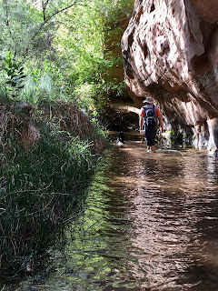
There is no trailhead or signage as this isn't an "official" hike but it's public land and once we had crossed the train tracks, we found a trail leading through the overgrown mouth of the canyon.  It was very green, choked with vegetation that had been bent over after the last storm's heavy runoff, and massive cottonwood trees.  Although there wasn't any water currently flowing in the creekbed, we did find a couple of pools which must have been spring-fed; further up, we would find other evidence of natural springs and seepages.

There's obviously enough water at some 
point to maintain all the trees

The canyon's steep walls loomed overhead, even as we exited the greenway and the canyon widened.  The trail seemed to correspond with an old mining or ranch road, climbing up out of the wash on looker's right as we headed upstream.  There was a lot of birdsong, including unusually loquacious canyon wrens, as the morning warmed up.  Other than that, we three were the only ones around, although there was a lot of coyote scat.  Milton didn't care as the lizards were starting to scurry about.

Milton on a lizard hunt

With the sun high enough that we were out of the shadows, and with the steadily rising slope, the sweat was just coursing off us.  We put Milt's white t-shirt on him, to reflect some of the sun's strong rays, and stopped often so he could have water.

The canyon really widened as we climbed
(this is a down-canyon view)

We weren't sure how close we got to the head of the canyon - which is somewhere below the Gemini Bridges trail complex - but we think we had it within sight when we stopped and turned around.  We were all overheating (the trail was climbing more steeply than we realized) but after some salty snacks, the return trip downhill and down-canyon was a piece of cake.  There was even a slight headwind, helping to cool us off.

Old fences

We had noticed some old fences and a water trough rigged to be filled by piped-in spring water; that, plus the old road convinced us that Day Canyon had been used for ranching and/or mining at some point.  It wasn't being used by anyone but us that day, except for a couple of rock climbers at the canyon mouth who we heard but didn't see.  It was a great hike, beautiful and solitudinous, with mostly easy footing, and I am counting the days until we can go back again, later in the fall when it's cooler, to see if we can make our way to the end.

Looking up canyon

Post-hike lunch and beers were at the empty Goldbar group site, at one of the covered picnic tables next to the boat launch where we had a view of the river - a darn good way to finish up.

Hike stats: 7.87 miles; moving 2:41 hours/2.9 m.p.h.; overall 3:13/2.4 m.p.h.; 1,090 feet of elevation

Wednesday, July 8, 2020

desert wheels

We got away to Moab for the long July 4th holiday weekend, lucking out on the weather a bit as the last of the cold front lingered, providing lower-than-normal temperatures for Thursday and Friday morning.  The fact that it is normally so hot down there right now (plus the pandemic) means that it's not super-crowded: there were some Utah and Colorado vacationers looking for an easy getaway, but not a ton because local folks know how hot it can be; what's really noticeable is that there are no European tourists these days.

To take advantage of the more temperate temperatures, we went up to Dead Horse Point State Park to ride Thursday morning.  It was gorgeous and clear, with the higher elevation keeping it cool first thing in the morning.  We managed to get out onto the trails just before a MTB tour group, doing the older east-side trails first and then going across via Crossroads to do the newer Whiptail/Twisted Tree loop.  We didn't see anybody on the first part of the ride and only started coming across other riders on our way back from the second part.  Trail etiquette was pretty good too, which tells you that there weren't that many newbie tourists out there.

That sky!

It definitely got hot again, starting mid-morning on Friday.  So when Saturday morning rolled around, we got out to the MOAB Brand Trails early-ish for our ride.  There were more vehicles there than we expected at 7:30 a.m., with four (!!) tour groups.  We started on the front side of Lazy-EZ, then managed to pass one of the tours just after the first cattle guard on Rusty Spur before returning to Lazy-EZ for the nice climb and swoopy downhill of its back half.

After that, I wanted to do the front side again to see if I could improve on my riding (I could).  Then we segued to Bar M, intending to do Circle O next.  I don't know if it was the heat or if I was unknowingly dehydrated, but I started cramping up just as we got out onto the slickrock.  When H waited for me, I decided to bail out and ride back to the truck - it was just going to take me too long to get around that loop.  I ended up hike-a-biking all the way back to the Bar M double-track - where I saw H, who had speedily finished the Circle O loop and was on his way back to Lazy-EZ.  I was riding okay but so v e r y  s l o w l y so that even though I took the cut-off back to the parking lot, I only finished five minutes before H got there.  After pounding a Gatorade (and, let's be honest, a hard seltzer), I was feeling better.  Some days are just shorter than others, I guess.


On Whiptail at DHPSP

DHPSP ride stats: 17.4 miles; 1:54 hours; 9.1 m.p.h. average speed

MOAB Brand Trails ride stats for H: 17.04 miles; 2:00 hours; 8.5 m.p.h.

Monday, July 6, 2020

reversal

We got up and out early Sunday morning, despite slightly fatigued legs from the Alta/Snowbird hike the day before, and got to the Round Valley trails around 8 a.m., the thought being that we would both avoid the crowds and get a decent ride in before the weather changed.  A cold front was due in the afternoon, with winds forecasted to pick up around 10 a.m.; we hoped there would be rain to help the plethora of wildfires that had sprung up (most human-caused, grrrr) nearby.

As luck (or our timing) would have it, there were very few people on the trails, right up until the witching hour of 10:30 a.m.  Even better, the people we did see - most with dogs, taking advantage of the cooler temperatures - had very good trail etiquette.  It's more fun when everyone follows the rules!

Coming up Rambler to Rademan Ridge

To mix things up a bit, H suggested that we ride reverse on a couple of trails: we'd go UP Rusty Shovel, which we'd only ever ridden down; and we'd do DOWN Tin Man and Happy Gilmor, which we'd only ever ridden up.  I was apprehensive about climbing Rusty Shovel since it's a fairly long climb that seems steep at the top, but I've never shied away from hike-a-bike. 

To my surprise, Rusty Shovel was a lot of fun to ride up!  And I rode a lot more of it than I thought it would, including the last few switchbacks towards the top.  It's not a particularly rocky trail, and for me that makes all the difference in my confidence.  The same cannot be said for doing Tin Man/Happy Gilmor downhill - both H and I found it more fun to climb, in large part because of all the chunks.  Lesson learned: we like to climb.

We split up for the last bit of our ride, with me beelining back to the truck via Round Valley Express and Matt's Flat with tired legs, and with H climbing Rambler and PorcUClimb and then racing a strong female MTBer down Down Dog.  We got back to SLC just in time for the cold front to arrive and after liberating poor Milton, sat in the garage while the thunder and lightning crashed dramatically over the Wasatch range.  No need to run the lawn sprinklers that night!


Ride stats:  16.88 miles; 1:55 hours; 8.8 m.p.h. average speed

Friday, July 3, 2020

first time back

The last time we were up at Alta was the last time we went skiing: Sunday, March 8, 2020, right before the pandemic changed everything.  It had been an abrupt end to the ski season (to everything, really) and we never got the chance to bid adieu to winter-time Alta.  So when we found ourselves in SLC for a weekend, we decided to put some elevation on our legs and revisit our Little Cottonwood Canyon stomping grounds.  This meant that Milton had to stay home, as no dogs are allowed in the canyon.  We left him a guilt biscuit in his food bowl as we slipped away early.

The Butterfly still apparent on Mt. Superior

It was a gorgeous morning, cool and clear, as we parked in the main Snowbird lot, one of only a handful of cars.  Although the White Pine trailhead had been absolutely packed - before 7:30 a.m. - traffic was light enough up where we were that we saw a couple of mule deer nonchalantly crossing the canyon road.  Birds were starting to call and the creeks were still tumbling full of water as we walked through Snowbird's resort center and followed the Bypass Road up to Alta.

Very pretty rose-colored paintbrush

Hiking at ski areas means one thing: it's gonna be steep.  We took the access road up Collins Gulch, which starts out steep with a vengeance.  The first section, going up along Corkscrew to the angle station, is just brutal.  After that it eases up a little, as the drainage widens and the road is able to cross the slopes in switchbacks.  The road was dry at the base but got more snow covered in the east- and north-facing sections as we went higher.

Still enough snow to ski Main Chute
but it gets bony further down

We passed one hiker on those wide switchbacks and then said hello to a trailrunner as we got to the top of the Collins lift.  The runner went down and we continued up the EBT to the trail accessing Baldy.  This is where most of the skiers bootpack up if they're going to ski Baldy.  Honestly, the first section is sketchy enough with dry rock and hiking boots on; I can't imagine trying to get up it with ski boots, carrying skis.  Once you get past that scramble section, however, it is a nice, if steepish, dirt path up to the summit.  We crossed paths with one solo hiker here, him going down as we went up.

Action shot!

On the way up we had debated whether we should hike down the front face of Snowbird or take the tram down.  From the top of Baldy, it was clear that the trams were running yet (they started at 10:30 a.m.), so the decision was made for us.  Plus, that meant that we didn't have any more up to do - downhill all the way back to the car.

Another view of the Superior Butterfly, 
from elevation (and also H)

About a third of the way down, it was evident why we prefer to hike up Snowbird and ride the tram down: it is so friggin' steep.  We took the Peruvian Gulch hiking trail, interspersed with some sections of the access road, and my quads, knees, hips and toes were loudly complaining before we'd gone a mile.  It's very steep, especially the trail, and the dirt and gravel underfoot are often loose, resulting in slips, slides and skids.  For someone like me who is not light on her feet, it can be treacherous - even for a dirt road!

Still some snow near the top of the Peruvian chairlift

Generally speaking, we were still a little early for the summer's profusion of wildflowers but they are starting to come out here and there, waiting for the snow to recede.  When we got back to the car, we realized that the usual hordes were delayed this summer too: usually, by noon, the Snowbird parking lots would be packed with tourists, MTBers, hikers and locals looking to escape the summer's heat.  Due to the pandemic, there will be no lift-served MTBing at the 'Bird this summer and they are reducing the number of people allowed in each tram car.  It was shocking to stand in the parking lot, drinking our post-hike beers, and not having any people to people-watch.  It's safer this way, I know, and I certainly appreciated not having to share the trails with very many other people, but it still takes some getting used to.


Hike stats:  8.75 miles; moving 3:19/2.6 m.p.h.; overall 3:49/2.3 m.p.h.; 2,840' elevation