Friday, March 26, 2021

weekend of wet walks

Wherein this outdoorsy blog turns into a food blog because of the "spring" weather.

After a glorious week of sunshine and temperatures above 60 F, winter returned to northern Utah with a vengeance, just in time for the first day of spring.  (Meanwhile, down in Moab, it was 70 and sunny.)  It had been windy all day on Friday as the cold front moved in.  Saturday morning, all the forecasters and Cottonwood Canyons ski areas were warning people: even though the canyon roads were dry in the morning, they were going to be wet (or worse) by afternoon.  A last chair/best chair scenario for those skiing but a nightmare for those trying to drive back down-canyon after a day on the hill.  The mountain cams showed heavy, wet snow coming down and with base temperatures above freezing, it was going to be a wet, wet day.  That, combined with the foreknowledge of a crummy return drive, kept H from skiing.  And as the canyon traffic accident reports started popping up in the afternoon and into the evening, he felt he had made the right choice.

Even down in the valley it was a pretty miserable day.  Milt and I cut our morning walk a little short since even though it wasn't raining when we started out, and the rain wasn't supposed to start for an hour, we got drenched and a little chilled.  He doesn't mind walking in the rain, though (unlike Becky, who very much disliked it), and I think he really likes getting toweled off afterwards.

The weather mandated a home-stay day.  While H awesomely swept (garage, mudroom and kitchen) and vacuumed (bedroom, living room, office and guest bedroom), I made banana nut muffins, a chocolate bundt cake with chocolate ganache, put away all the clean laundry that had been sitting in a pile for the week, conditioned the wooden cutting boards with coconut oil (they look like new! almost!) and made soba noodles with broccoli, snow peas, spicy baked tofu and a red curry and peanut sauce. 

Sunday's weather was positively schizophrenic.  Again, I checked the weather - "flurries" for the next hour - but Milt and I weren't three blocks from home when it started snowing so hard I wished I was wearing ski goggles.  It had reduced to actual flurries about halfway through our walk and by the time we were heading downhill into the home stretch, the sun was breaking through and I took my mittens off - although the damage was done and we were wet and a little chilled.  For the rest of the day, it alternated between snow and patches of sun.  We snuck out of the house for a couple of hours around noon, leaving the dog snoozing on our bed, to go have a beer at the Hog Wallow.  It made us a little twitchy to be out in public but staff and patrons were all conscious about distancing and we left before too many skiers showed up for some apres.  

Tuesday, March 23, 2021

moab rim, reversed (sort of)

I won't say that it was nice weather on Sunday, but the rain did cease long enough for the three of us to get our Moab Rim hike in.  When we got to the trailhead parking lot, we (and a trail runner and another hiker with a dog) had to wait to pull in because a crew of jeepers from Alabama Nebraska was staging, taking up the whole lot and blocking the entrance.  We non-jeepers were a little annoyed but were able to pull in when the group started up the 4x4 trail.

Low cloud ceiling

We went up the Stairmaster hiking trail (to looker's right as you go up) to stay out of the way of the jeeps but we needn't have worried.  They were very slow, some of them getting hung up on obstacles almost immediately, and we soon outpaced them.  Although we quickly warmed up (that trail is very steep), the air was cool and smelled clean, damp from all the rain.  At the top, we caught up to the other hiker with her dog - a medium-sized lab with striking coloring - and Milton managed to entice the lab into a quick game of chase while we humans chatted.

H heading down into the wash

We caught up to another couple of hikers just before the trail split - they didn't have a dog but admired Milt's spotted paws - and then we went left, doing the wash for our outbound.  There were plenty of puddles for Milton to drink out of and the sand in the wash was sticky/muddy in places but we didn't see any ephemeral waterfalls, even though we thought we might.

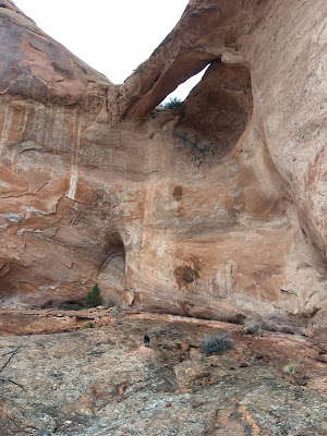
40 lb. dog for scale

We did see a new-to-us arch up on the wall as we headed down into the wash, the colors of the rock somewhat muted in the flat, grey light.  We had the outer portion of the hike to ourselves - no coyotes this time - except for that trail runner who passed us as we were heading back out.  When we got back to the big ramp of the Moab Rim trail, overlooking the Colorado River, we started coming across quite a few other hikers.  We also encountered those Alabama jeepers who were making v  e  r  y  slow progress.  They smiled and waved at us as we went by, however, so I guess it's the journey and not the destination that matters.  That being said, when we arrived at our destination (the car), it started to rain again so I was glad that day's journey was over.

Hike stats:  5.51 miles; 1:59 hrs./2.8 m.p.h. moving average; 2:15/2.4 overall; 1,470' feet of elevation

Friday, March 19, 2021

damp desert

Yikes - that was a quick week!  It completely got away from me.

H should have been a meteorologist.  Not the local news weatherman but the scientist with the data and the readings and the forecasts.  I almost always ask him about what the weather is going to be rather than checking the weather apps on my phone.  Almost always: last weekend when we were down in Moab, I brought my raincoat.  H, he was working off an outdated forecast that showed 50s and partly sunny through the week.  I was right.  Maybe I should be the meteorologist!

It's starting to get green

Saturday morning, the actual forecast made it look like we might have a window of opportunity for a quick hike in the morning.  We got our hiking gear together and drove over to the Moab Rim trailhead and just as we pulled in, it started sprinkling.  We sat there for a little while - Milton wondering why we weren't getting out of the car - and then H decided that he didn't really want to hike in the rain.  40s and raining is our second-least-favorite kind of weather, so I completely understood.

Watermelon rock

Milton and I still needed some exercise, however, so H drove us down to the Hidden Valley trailhead, where there were several other vehicles with people sitting inside, staring at their phones.  Milt and I got out; I put on my rain poncho; we waved goodbye to H and started hiking north on the Pipedream trail.  Once we got going, I was plenty warm, even taking off my gloves so they wouldn't get too damp.  The rain sprinkled on and off - and so I put on or took off my poncho accordingly - but never amounted to much, all the way to the Jackson Street exit.  We'd only been out for an hour (hadn't seen anybody) so I texted H that we were going to do the northern half of the trail too.

Precip

The trail was in good condition actually, never wet enough to rut up or get muddy.  At one point, nearing the upper end of the trail, the precipitation picked up briefly, showering us with sleet/graupel.  It didn't last long, however, and by the time we met a couple of labs and their trail running people, I had my poncho off again.  We left the trail at the Aspen Street exit, walking back along Kane Creek Boulevard and lower Main Street, and the rain held off again until we got home.  We timed it just right: from about noon through 4 p.m., it rained a LOT, segueing into huge, wet snowflakes for short periods, filling the gutters with run-off and completely drenching us from the knees down when we ventured out for a quick, socially-distanced beer at Woody's around 2 p.m., raincoats and ponchos notwithstanding.


Friday, March 12, 2021

white frosting

Last weekend we spent in SLC where, according to all the crocuses that I saw springing up in everyone's yard, spring was giving us a preview.  Milton and I did our homebody thing with our long walks in the morning (on Sunday, we met Oakley, a year-old something-doodle, in a park near our house and she and Milt chased each other around and around and around), and then got all domestic.  If spring is really coming, it's going to get too hot to bake so I figure I need to take advantage of the still-cool weather.

Can you believe I even have a cake stand?

I made a pan of scratch brownies that went directly into the freezer, a batch of banana-nut muffins (both pecans and walnuts) and that golden milk cake that I made before, although this time - at H's suggestion - I doubled the recipe.  That means double the cake, y'all, and that's a good thing.


It looks like cake (crappy food 
styling/photography notwithstanding)

I also made a vegan chorizo soup for the freezer and we had two new recipe attempts for dinners: a 
tantanmen ramen (delicious but a lot of work for a soup) and a tamale shepherd's pie (which sounds odd but was yummy and made a LOT of food).  

The snow in the Ballroom looks like my vanilla frosting

I also did all the laundry and vacuumed the stairs, but no one wants to hear about that.

Superior looming large in the distance

H went skiing both days, where it was mostly clear, a little chilly, a little crowded and all skied out, what with no new snow for a week.  Conditions were very firm until about 11 a.m., when the sun got high enough to soften things up; off-piste in the morning was not recommended.  Alta had finally opened Devil's Castle on Friday (?) for the first time all season, the low snow having kept it closed until now.  H also reported that patrol was working on East Castle; that area hasn't been open either but that's not atypical in a low snow year.


Tuesday, March 9, 2021

brisk

Sunday morning in Moab, while sunny, reminded us that winter is not quite over, even in southern Utah.  It was sunny and clear, but temperatures were definitely colder (30s) than Saturday and there was a brisk wind that found all the gaps in our clothing.  There was no snow in the forecast, however, so we didn't need to hurry back north.

View east towards Arches NP

After a false start where we had to go back home for some forgotten gear, we ended up at the MOAB Brand Trails, H with his MTB and me and Milton on foot.  We hikers did the same loop as last time: the parking lot cutoff to Bar M loop; south on Bar M to Circle O; counterclockwise on Circle O back to Bar M; south on Bar M again to the parking lot cutoff.  We had the whole place to ourselves, aside from two trail runners and their friendly dog.

Milton loves slickrock

H did a similar route to last time, consisting of Lazy-EZ, Rusty Spur, the Copper Ridge trail and the Bar M loop.  Copper Ridge is a connected series of several trails north of Moab on the western edge of Arches National Park, connecting MOAB Brand, Klondike Bluffs and the Sovereign trails.  The portion H rode was gentle double-track and he didn't have to share it with anybody.  We need to appreciate these chilly, gorgeous days when no one is around - spring is coming and with it, the hordes.

Saturday, March 6, 2021

four arch canyon

Last weekend down in Moab was picture-perfect winter desert (in my mind, anyway): clear, sunny and not too cold.  It never got above the low 40s but when the wind didn't blow, the sun felt great.  Saturday morning we decided to explore somewhere new to us: Four Arch Canyon.

Beautiful morning

We drove out Route 313 and turned left onto the Gemini Bridges Road.  There were a handful of MTBers there, pulling their bikes off the shuttle and getting ready to ride the innumerable trails.  The road was in good shape - hard and dry - unlike the first time we had thought to try this hike a month or so ago, when it was snow/ice-covered with sticky mud patches.  We drove in just under five miles, parking at the signed turn-off for Four Arch Canyon and Crips Hole.  4WD vehicles could continue in further but we didn't want to risk the little Subaru, plus it didn't add much mileage to the roundtrip.

What lurks under the rocks

We walked in along the road, Milton wide-ranging as usual but striking out on finding any critters to chase: it was still too chilly for lizards and while there must have been rabbits around, they had made themselves scarce.  We did see plenty of range cattle sign - footprints and poop - but no actual cows.


In the wash

We were using the post linked in the first paragraph as our trail guide but it was a little confusing at one fork in the road, so we got off track a little bit, having to walk through the closed (or abandoned) Desert Dream ranch (dude ranch?) before getting back onto the canyon road by a Boy Scout camp.  From there we just followed the 4x4 road into the canyon.  This is an easy out-and-back hike with plenty of solitude and stunning scenery.

Shadow Arch

The sun climbed above the towering red cliff walls as we made our way to the head of the canyon.  There are four arches in this canyon (as you may have guessed): Bullwhip Arch and Mosquito Arch, easily found on the north side of the canyon/hiker's right on the way in, Shadow Arch high up on the south side and Crips Arch, which we never found.  We didn't see Shadow Arch until we were on our way back out; after we located it, we noticed that someone had actually built a small cairn on the side of the jeep road as a marker.

Mosquito Arch

The canyon ends in a good-sized bowl with an impressive pour-off.  On our way out, we walked along the wash for a bit, just for something different.  When we were almost out of the canyon proper, we met a Sprinter van and an SUV, turning around before getting stuck in the sand; as we passed by the scout camp, four more vehicles (jeeps and pick-up trucks) were heading in.  That's not a lot of traffic per se but we were glad to have had the scenery all to ourselves.

Bullwhip Arch

 Later, back at home, we realized that Crips Hole is located in a whole other canyon, likely the one you turn into when you cross a wide wash before the turn-off to the scout camp.  Now we're going to have to go back and check that out too.  With an area that pretty, that's not a tough sell.

Hike stats:  6.78 miles; moving 2:25 hours/2.8 m.p.h.; overall 2:50/2.4; 840 feet of elevation