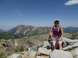
Unnamed peak; hiker name: H
We were on the trail at 7 a.m., enjoying the cool air and the almost-but-not-quite-at-peak wildflowers on the lower ski runs under the Majestic and Crest Express lifts. We encountered just a couple people before the Dog Lake turn-off and then no one (other than a fair number of unwelcome but slow-moving mosquitoes) as we made our way up. That trail through Brighton's bowls is just wonderful. It climbs steadily but is smooth and gentle underfoot, hard-packed dirt and pine needles - super-cushy. The last bit to the summit is steep with small boulders to scramble; cross-sounding pikas scolded us as we made our way up. Then it was summit #1, Clayton Peak, at 10,750 feet above sea level.
Lakes Mary and Martha from Pioneer Peak
There was no time for lingering, however, because this summit had taken us longer than I thought it would (failure to adequately research falls on me). We also weren't sure how to get to our next summit and had to descend much further than I had hoped before finding a dirt access road which would take us up. This "ridge run" does have a trail but it is faint and fades in and out; a recurring theme for the hike would be losing and re-finding the path. We made our way up through the wildflowers to the ridge behind the top of the Crest Express lift and started around.
Catherine's Pass/Lake Catherine and Tuscarora
That first summit is apparently unnamed (elevation 10,315 ft.) and the trail is barely there either. It's easy to know where you're going on a ridge, however, so we picked our way through the boulders until we found the trail again. There is a fair amount of up and down on this hike, as we descended to the low point and then scrambled up to Pioneer Peak (10,447 ft.). From here, on our left a gorgeous green drainage fell away towards the Heber Valley, and to our right, the Brighton lakes were as full as we've ever seen them, compliments of all the wonderful snow we got this past winter.
Last summit: Mt. Wolverine
From Pioneer Peak to the popular Sunset Peak is probably the sketchiest part of the ridge run. We lost (and found) the trail several times; the footing is extremely sandy and loose; and the ground falls away very steeply, so that whole section is absolutely a "no-fall" zone. It is also a no-other-hikers zone, which is always a treat in the increasingly busy Wasatch.
Wolverine Cirque
There were, however, scads of people atop Sunset Peak 10,648 ft.), as we knew they would be. Lots of hikers will nab that summit as it is an easy extension from Catherine's Pass, whether you've come up from the Alta side or the Brighton side. We left the crowds behind us as quickly as we could, pausing for snacks at Catherine's Pass (where we grievously disappointed the resident chipmunk who had been hoping for dropped goodies) before continuing on. Again, there was a bit of route-finding as the trail faded in and out, but we eventually found ourselves at the summit of Mt. Tuscarora (10,654 ft.), a popular winter summit for backcountry skiers. We had to cross a bit of snow on our way down and back up to Mt. Wolverine (the high point at 10,795 ft.), and then the footing was a bit precarious in spots - narrow, rocky, loose - as we skirted Wolverine Cirque. We even encountered a skier, resting a bit before his second run down the cirque. When asked how it was, he said, "It's a little wavy. But it's good for July," and then grinned at us. Wish we'd gotten to see him ski.
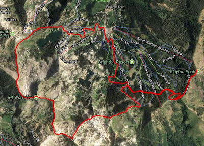
I love this map
We continued around the ridge, picked our way down the boulder field to Twin Lakes Pass. Here, two things were evident: the wildflowers are truly on the verge of peak gorgeousness; and there is so much water in the reservoir that Twin Lakes is just one lake right now. It's great to see. From there, it was basically a long slog out via the ski resort's access roads. It was hot and the gravel footing is looser than I like since my hiking boots tend to slip on the loose stuff. But cold beer and sandwiches were waiting for us at the car and that's good motivation.
Pretty sexy profile there
When the stats were pulled together, we ended up doing 10.64 miles with 4,100 feet of climbing (4:37 hiking and 1:19 stoppage time meant about six hours on the trail all told). That was a longer hike than I had envisioned [see above re poor research skills] but it is such a beautiful hike, and manages to avoid the teeming hordes even located where it is. Totally worth it, every time.


No comments:
Post a Comment