
Boys hiking
Back in August, when we rode the Navajo Rocks trails, we discussed doing some winter hiking on the 4X4 that ran under the Entrada cliffs. Once we got out there, however (and were only the second car in the parking lots because brrrrr), we ended up on the Ramblin MTB trail which followed the line of the cliffs but weren't right under them. We descended wide level benches of slickrock, crossed a couple of washes (including what we think is the head of Seven Mile Canyon) and went through some rolling sandy patches before ending up at a small parking area at 313. This would be a fun MTB ride - I think I could ride a lot of it - but it's only a little over three miles long.

Monitor and Merrimac from Ramblin
At this point, we had a decision to make: retrace our steps on Ramblin, for under seven miles total, or make a loop by crossing 313 and heading back up via Rocky Tops and Middle Earth, which would put our mileage over nine. We didn't want Milton to overdo it but watching him out there, happily chasing a golden retriever across the rock and clearly loving being out here, we decided to take the long way back.

Views wherever you look
As far as MTBing goes, Rocky Tops is rather more technical than Ramblin; as far as hiking goes, it's terrific. For the duration, we kept passing and getting passed by a couple groups of MTBers: they would pass us on the flats and then we would catch and pass them on the more technical sections. There's a little bit of everything out there on those trails, from doubletrack to sandy singletrack to steep switchbacks to sidehill sandstone to rolling slickrock benches. It would be a very hot hike in the warmer months - there is no shade out there at all - but it was fantastic in early December.
When we got back to the parking area, it was PACKED. A big group next to us was making tailgate coffee and brunch post-ride; there were several dogs for Milton to meet; other people were just warming up and heading out on the trails.
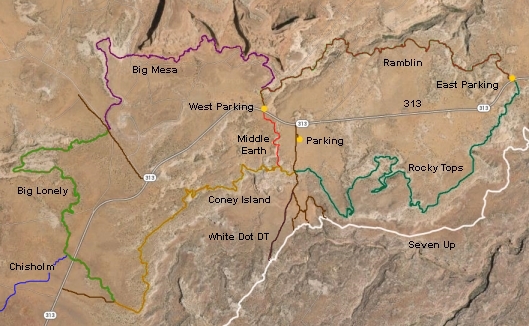
Map from utahmountainbiking.com (great site, tons of
information) because our GPS's batteries died mid-hike

Map from riderdestinations.com

Ridge-walking
Our plan worked and we saw no one out there until we switched to the Slickrock MTB trail around the Escalator obstacle. From there it was still two miles out to the trailhead (we would total over five miles on this one) and we saw several MTBers as the day got warmer. It was a ghost town compared to the spring/summer/fall, however. I anticipate more hiking up there in winter solitude.


No comments:
Post a Comment