Glowing sunrise due to drifting wildfire smoke
It was H's idea to start from the northern terminus and walk south, figuring that the traffic might be a bit lighter there along the popular, multi-use (hikers, MTBers and horses) trail. We were the first to park at the Bear Hollow Drive trailhead, heading up Rob's Trail to connect with the Mid Mountain Trail.
Here's the sun
We weren't sure how chilly it would be that early at that elevation but it really wasn't cold at all; I didn't need my arm warmers at all and had stuffed my gloves into my pack less than twenty minutes in. It would end up being 90F by the time we were done with our hike - which is quite hot for Park City.
Canyons ski trails
H's instincts about the trail use were spot-on. We didn't see anyone - other than the partridges that kept exploding out of the underbrush and scaring us - for hours.
Super Condor Express
The trail is fantastic: mostly packed dirt with only a few rocky
sections. The direction we were going was a gradual uphill, with great
switchbacks, keeping it MTB-friendly, all the way to Canyons' Super Condor Express chair. Then we started descending, past Alpine Lake and the top of the Sun Peak Express chair, through the Red Pine Lodge area and out of Canyons property. It did not go unnoticed that every foot down meant that same foot up on the return.
Last vestiges of snow, insulated by all that dirt
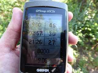
At 9.00 miles on the GPS, we stopped. It was shaded, with a bench by a dry creek, and we had some snacks and refilled our water. Although the hiking had not been a lot of work since there weren't any steep sections, we were hot and very sweaty. Now all we had to do was go back. What's funny is that all photos were taken during the first half of the
hike. We were on cruise control to finish the back nine.
Speedy (for us)!
When we got back to Red Pine Lodge, the lifts were running and there were tourists milling about. We encountered MTBers then on the section of the trail north of Red Pine Lodge, heading both north and south, but everyone was super-friendly and considerate. We outdistanced the few hikers heading our direction and even passed one MTBer! He was clearly a tourist and suffering from the elevation.
Nine down, nine to go
Things got busy when we got back to Rob's Trail for the final descent, with lots of casual hikers, with kids and dogs, getting in our way. At this point, we were ready to be done. Both of us had numerous hot spots and/or blisters on both feet - which was weird because that didn't happen at Ben Lomond, which is only two miles shorter - and my left knee was sore.
It was thus with both a sense of relief and a sense of accomplishment when we finally got back to the car, where dry socks and cold beer awaited us. The question had been, could we do eighteen miles? The answer was most definitely yes.
Hike stats: 18.00 miles; hiking time 5 hrs. 51 min. at 3.1 m.p.h.; total time 6 hrs. 37 min., with avg. speed of 2.7 m.p.h.; 2,237 feet of climbing


No comments:
Post a Comment