After a do-nothing Saturday (yes, every now and again we have one of those), we weren't inclined to sit around the house again on Sunday. We checked the trail conditions in Park City and determined that while they were likely too muddy for us to want to MTB, they were probably okay for hiking. On our way to the trails, however, we stopped off for breakfast at a new place for us, the No Worries Cafe.
Just off I-80 in Parley's Summit, the No Worries Cafe & Grill is a tiny little breakfast and lunch spot that looks like it doubles its seating in the summer with tables on its deck outside. It was quite busy but we didn't wait for longer than fifteen minutes and there's free coffee to sip while you wait. They had some great-sounding specials on the multiple chalkboards but H and I went with some tried-and-true dishes from the regular menu: huevos rancheros for him and biscuits and gravy for me. I'll cut right to the chase: breakfast was really good. H's huevos came out unassembled, which is kind of fun: a large, folded-up flour tortilla, scrambled eggs, beans, salsa, sour cream, cheese, hash browns, two strips of gorgeous bacon and a sizable dish of sliced jalapenos. My biscuits and gravy were terrific, quite possibly the best I've had. Two eggs (over medium), hash browns, two biscuits and sausage gravy, plus two sausage patties - all for $8.50. The country-style gravy was hot and very good, flavorful and well-seasoned with plenty of sausage chunks. I would go back to the No Worries Cafe any time.
We also had a minor celebrity sighting at breakfast: Jason Kreis, the head coach of Real Salt Lake, came in with his wife and sons. I'm not sure how many other breakfasters besides us recognized him, and we certainly didn't let on that we knew who he was, but for anyone who knows anything about soccer he's kind of a cool guy: First team all-state (Nebraska) as a freshman in high school; while playing for his first MLS team, the Dallas Burn, he scored their inaugural goal, lead the league in goals and points, was the first American-born player named MLS MVP and was a five-time all-star; he was the first player hired to play for RSL when that team was founded, scored RSL's first goal and was the first player in MLS history to score 100 goals. He's still the fifth highest scorer in MLS history, despite having retired in 2007 to take the head coaching job at RSL. And, by all accounts, he's a really good coach which is not usually the case with really talented players. Anyway, we saw him, he was eating eggs with his family, and we hope that his team does well in their playoff game this coming Thursday.
Sunday, November 4, 2012

Thursday, November 1, 2012
where the deer and the antelope play
Our Sunday activity was quite nearly the opposite of our Saturday one: we still went hiking, but we drove north to Antelope Island and walked for 11.2 miles on dry, sandy trails wearing t-shirts and shorts. We even got sunburned!

Once across the causeway and on the island, we drove to White Rock Bay on the west side. The bison round-up had just occurred and we could see the big beasties in the corrals up on the hill to the north of the beach. There were several other vehicles in the day-use parking lot: trucks hauling horse trailers and cars with bike racks; a number of MTBers rode into the lot as we were heading out, leading us to understand that there actually are MTB-friendly trails in this state park.
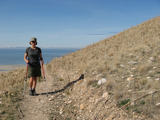
We did the White Rock Loop, plus an out-and-back jaunt to Elephant Head, and once out there really didn't see too many other people, a few trail-runners, a few MTBers, a few folks on horseback. The White Rock Loop trail is lovely, running level about mid-way up the rolling hills, the low grasses toasted gold from the summer's hot sun. It is so wide open out there that you can see everything: distances look great but the miles just disappeared under our feet with the easy walking.

To go out to Elephant Head, you have to climb up a little bit to the ridgeline, then walk out on that level to the bluff. There was bison poop everywhere up there - it must be a favorite spot of theirs. The whole west side of the island drops away from that trail. It couldn't have been more different from what we'd been doing just the day before.

Antelope Island is a great place for wildlife viewing. On our just-under 4 hour jaunt, we saw: bison, pronghorn antelope, mule deer, two coyotes, chukkars, hawks and a cowboy sipping on a can of Budweiser while he was a-horse. After the hike we went up to the bison corrals. Hundreds of them were there, the older ones lying down unconcernedly, the younger ones milling about more nervously. The noise the herd was making was great, sort of a low, humming, grunting, collective groan. Antelope Island State Park is such a cool place (I don't understand why more locals don't go there) - if you're ever visiting the greater SLC area, it's worth the trip.

Looking southeast to the island's center
from the White Rock Loop trail
Once across the causeway and on the island, we drove to White Rock Bay on the west side. The bison round-up had just occurred and we could see the big beasties in the corrals up on the hill to the north of the beach. There were several other vehicles in the day-use parking lot: trucks hauling horse trailers and cars with bike racks; a number of MTBers rode into the lot as we were heading out, leading us to understand that there actually are MTB-friendly trails in this state park.

Pretty cushy walking
We did the White Rock Loop, plus an out-and-back jaunt to Elephant Head, and once out there really didn't see too many other people, a few trail-runners, a few MTBers, a few folks on horseback. The White Rock Loop trail is lovely, running level about mid-way up the rolling hills, the low grasses toasted gold from the summer's hot sun. It is so wide open out there that you can see everything: distances look great but the miles just disappeared under our feet with the easy walking.

The Wasatch, peeking over the ridge of the island
To go out to Elephant Head, you have to climb up a little bit to the ridgeline, then walk out on that level to the bluff. There was bison poop everywhere up there - it must be a favorite spot of theirs. The whole west side of the island drops away from that trail. It couldn't have been more different from what we'd been doing just the day before.

Couple of big guys who did not get rounded up
Antelope Island is a great place for wildlife viewing. On our just-under 4 hour jaunt, we saw: bison, pronghorn antelope, mule deer, two coyotes, chukkars, hawks and a cowboy sipping on a can of Budweiser while he was a-horse. After the hike we went up to the bison corrals. Hundreds of them were there, the older ones lying down unconcernedly, the younger ones milling about more nervously. The noise the herd was making was great, sort of a low, humming, grunting, collective groan. Antelope Island State Park is such a cool place (I don't understand why more locals don't go there) - if you're ever visiting the greater SLC area, it's worth the trip.
Tuesday, October 30, 2012
hiking in solitude
We had a little snow storm last week that dropped a tantalizing amount of snow in the mountains (and a couple of inches on our lawn, which didn't last long): nearly three feet north of SLC, at Powder Mountain and surrounds, and about a foot and a half in our own Cottonwood Canyons. On Saturday we decided that we should go up and tromp around in it. One of our very first hikes when we moved here was up at Silver Lake, trying to find Lake Solitude; we never found it that day, but since then we've skied that area enough that we figured we could locate it this time.

We started up at the Solitude Nordic Center in Brighton, by Silver Lake, taking the well-beaten lake path around to where the hiking/MTBing trails split off. We'd brought our snowshoes but decided not to use them - this would ultimately be the right decision, although we did break trail in a couple of places where they would have been useful. But I was wearing plastic bags between my hiking boots and my wool-socked feet and a little knee-deep snow wasn't going to be an issue.

Just like the first time we tried to find Lake Solitude, we started following a trail ... that we eventually lost. But we recognized Solitude Ski Resort's Sunrise chair, crossing under it and walking across the top of North Star to Zip-A-Dee, which comes out above the Summit chair. From there we knew what to do, making our way through the trees to little Lake Solitude (not quite frozen over). H suggested that we make this hike a loop and since a loop is always better than an out-and-back, I readily agreed.

Our route - up Mine/Shaft and through the Headwall Forest to Sol-Bright - had been traveled before: we walked in ski-, boot-, snowshoe- and deer-tracks. We went over the pass between Solitude and Brighton, continuing along the less-trodden Sol-Bright trail and then turning off on the well-packed trail back to Silver Lake. It was a beautiful day, sunny and fairly warm, and we had the place pretty much to ourselves for a couple of glorious hours.


Just leaving Silver Lake
We started up at the Solitude Nordic Center in Brighton, by Silver Lake, taking the well-beaten lake path around to where the hiking/MTBing trails split off. We'd brought our snowshoes but decided not to use them - this would ultimately be the right decision, although we did break trail in a couple of places where they would have been useful. But I was wearing plastic bags between my hiking boots and my wool-socked feet and a little knee-deep snow wasn't going to be an issue.

Snow in the trees - so pretty
Just like the first time we tried to find Lake Solitude, we started following a trail ... that we eventually lost. But we recognized Solitude Ski Resort's Sunrise chair, crossing under it and walking across the top of North Star to Zip-A-Dee, which comes out above the Summit chair. From there we knew what to do, making our way through the trees to little Lake Solitude (not quite frozen over). H suggested that we make this hike a loop and since a loop is always better than an out-and-back, I readily agreed.

Under the Summit chair
Our route - up Mine/Shaft and through the Headwall Forest to Sol-Bright - had been traveled before: we walked in ski-, boot-, snowshoe- and deer-tracks. We went over the pass between Solitude and Brighton, continuing along the less-trodden Sol-Bright trail and then turning off on the well-packed trail back to Silver Lake. It was a beautiful day, sunny and fairly warm, and we had the place pretty much to ourselves for a couple of glorious hours.

Along Sol-Bright
Saturday, October 27, 2012
new boots
Oops! A couple days got away from me without posting - sorry about that. We've been doing stuff, I promise.
Case in point: H and I were 3+ years overdue to buy new ski boots so we recently found our way to the Sport Loft (4678 S. Highland Drive, Holladay). It was purely by chance that we landed there - after an internet search for "Salt Lake City ski boot fitters" or somesuch - we're very glad we did. It was quite an experience. Neither of us has ever had custom boot fitting before and we didn't know what to expect.

What you get at the Sport Loft, which has been in business and run by the same family for 40 years, is the undivided attention of Earl and Jeremy Middlemiss, father and son, for three hours as they ask exhaustive questions about your skiing (current equipment, days on the hill, skill level, technique), measure your feet and observe your stance. Then they try you in three or four different brands of ski boots, each time asking careful questions about the fit at multiple places on your feet. When a boot is decided upon, the next step is to pad your feet, depending upon your physiology's idiosyncrasies, and then heat-mold the boot liners around your feet. We each also got custom orthotics to correct our stances and, in my case, compensate for my fallen arches. My new boots, Fischer Trinity 110s, went one step further and I had to stand motionless in a heat/vacuum contraption for fifteen minutes as the shell was customized to my feet. H got to take his new Lange RX-130s home with him that night. My boots had to cool and cure on a flat surface for 24 hours, so I didn't go back until the next day to try them on and get the bindings on both pairs of skis adjusted.

Custom boot-fitting at the Sport Loft is not particularly cheap but the level of service you get is seemingly unprecedented. Earl and Jeremy paid attention only to us for the duration of our fittings and took their time answering all our questions. When I went back for my boots, Earl walked out to the car with me and insisted on carrying not only my boots for me, but also both pairs of my skis. He even picked out new ski socks for me! There was a ski instructor (19 years at Alta, this year at Canyons) in the shop finishing up his fitting when H and I showed up initially, and he told us that without a doubt, Earl and Jeremy are the best fitters anywhere. H and I were certainly impressed with the personalized service we got and now, more than ever, we're excited to get on the hill and see what our new boots can do.
Case in point: H and I were 3+ years overdue to buy new ski boots so we recently found our way to the Sport Loft (4678 S. Highland Drive, Holladay). It was purely by chance that we landed there - after an internet search for "Salt Lake City ski boot fitters" or somesuch - we're very glad we did. It was quite an experience. Neither of us has ever had custom boot fitting before and we didn't know what to expect.

Trying not to move during
the vacuum process
What you get at the Sport Loft, which has been in business and run by the same family for 40 years, is the undivided attention of Earl and Jeremy Middlemiss, father and son, for three hours as they ask exhaustive questions about your skiing (current equipment, days on the hill, skill level, technique), measure your feet and observe your stance. Then they try you in three or four different brands of ski boots, each time asking careful questions about the fit at multiple places on your feet. When a boot is decided upon, the next step is to pad your feet, depending upon your physiology's idiosyncrasies, and then heat-mold the boot liners around your feet. We each also got custom orthotics to correct our stances and, in my case, compensate for my fallen arches. My new boots, Fischer Trinity 110s, went one step further and I had to stand motionless in a heat/vacuum contraption for fifteen minutes as the shell was customized to my feet. H got to take his new Lange RX-130s home with him that night. My boots had to cool and cure on a flat surface for 24 hours, so I didn't go back until the next day to try them on and get the bindings on both pairs of skis adjusted.

New boots! So pretty!
Custom boot-fitting at the Sport Loft is not particularly cheap but the level of service you get is seemingly unprecedented. Earl and Jeremy paid attention only to us for the duration of our fittings and took their time answering all our questions. When I went back for my boots, Earl walked out to the car with me and insisted on carrying not only my boots for me, but also both pairs of my skis. He even picked out new ski socks for me! There was a ski instructor (19 years at Alta, this year at Canyons) in the shop finishing up his fitting when H and I showed up initially, and he told us that without a doubt, Earl and Jeremy are the best fitters anywhere. H and I were certainly impressed with the personalized service we got and now, more than ever, we're excited to get on the hill and see what our new boots can do.
Tuesday, October 23, 2012
rocky shores
It was still kind of overcast and chilly on Sunday so we headed back up to town to give the Hogle Zoo another go. It was busy but not packed and we headed in. Quite a bit has changed since we were there last: the whole center of the zoo is under construction for the new 4.5 acre "African Savanna" exhibit, which will house giraffes, zebra, ostrich, small antelope and lions, presumably not all together. The drawing of the proposed exhibit looked nice, a much better habitat for the giraffes (speaking of the giraffes, a new baby was born just a month ago) and the lions will be a new addition to the zoo. During this construction, a number of animals have been moved, unavailable for viewing or maybe transferred to other zoos: the bison, peccaries, camels, black bears and mountain lions. We do hope they bring the bear and the cougar back as it's important to have native Utah animals on display.

But on to the real reason we went to the zoo - the new Rocky Shores exhibit. The newest completed exhibit, they've done a really nice job of creating interesting habitats for the new river otters, sea lions, harbor seals, polar bear and grizzly bears. Rizzo, the polar bear, has a big habitat to herself, with plenty of room to swim and coming up close to the viewing area to the delight of all the people watching. Next door, the seals and sea lions share a pool, although it's big enough that they don't have to interact if they don't want to; the two young sea lions were having a ball, wrestling with each other underwater, porpoising up out of the water, chasing each other; the older sea lion, who I think is blind, kept out of their way but was clearly at home, swimming easily through the habitat.

Most impressive were the three grizzly bear cubs, two females and one male, who don't seem much like cubs anymore. The zoo acquired them from the wild near Yellowstone after their mother killed a camper and had to be put down. These siblings are going to be huge and their habitat is better fortified than any others in the zoo. One of the cubs was more active than the other two and walked up to the viewing window several times to look at the people looking at him; his claws were easily over two inches long and extremely intimidating. It's very clear that these are wild animals.

We ended up spending a couple of hours walking around and looking at all the animals. I think they've done a very nice job with the Rocky Shores exhibit and would expect more quality work for the African Savanna exhibit as well. The Hogle Zoo doesn't have much space to work with so I'm glad to see them making the most of what they have for their animals.

Those fences are electrified so the
zoo's neighbors don't worry about escapees
But on to the real reason we went to the zoo - the new Rocky Shores exhibit. The newest completed exhibit, they've done a really nice job of creating interesting habitats for the new river otters, sea lions, harbor seals, polar bear and grizzly bears. Rizzo, the polar bear, has a big habitat to herself, with plenty of room to swim and coming up close to the viewing area to the delight of all the people watching. Next door, the seals and sea lions share a pool, although it's big enough that they don't have to interact if they don't want to; the two young sea lions were having a ball, wrestling with each other underwater, porpoising up out of the water, chasing each other; the older sea lion, who I think is blind, kept out of their way but was clearly at home, swimming easily through the habitat.

Bear on the move
Most impressive were the three grizzly bear cubs, two females and one male, who don't seem much like cubs anymore. The zoo acquired them from the wild near Yellowstone after their mother killed a camper and had to be put down. These siblings are going to be huge and their habitat is better fortified than any others in the zoo. One of the cubs was more active than the other two and walked up to the viewing window several times to look at the people looking at him; his claws were easily over two inches long and extremely intimidating. It's very clear that these are wild animals.

Can you see those claws? Yeesh ...
We ended up spending a couple of hours walking around and looking at all the animals. I think they've done a very nice job with the Rocky Shores exhibit and would expect more quality work for the African Savanna exhibit as well. The Hogle Zoo doesn't have much space to work with so I'm glad to see them making the most of what they have for their animals.
Sunday, October 21, 2012
columbus power plant
We keep hoping that it'll warm up enough to go MTBing one more time before the season ends, but this weekend was not that weekend. So on Saturday we did a new hike up Little Cottonwood Canyon - well, not really a hike but more like walking and exploring someplace we hadn't been before. H had printed off Charles Keller's "Faint Trails in the Wasatch" article from the October Rambler (online magazine put out by the Wasatch Mountain Club) about the ruins of a power plant along the LCC creek which gave the town of Alta its first electric lights in 1904.

Although the walk in to the Columbus power plant is really quite short, between walking up and down the Little Cottonwood Canyon Trail and rock-hopping along the creek (a skill I'd forgotten I had; I get it from my dad who's really good at it) we managed to put in about 5 miles. To get to the trailhead you go up the LCC road, following the mile markers to around 6.5 miles. There's a small marking area on the south side of the highway and an old road leads down to the LCC Trail. Turn left at the trail and walk up no more than half a mile.

As I said, though, we did quite a bit of walking first since the LCC is so pretty this time of year. There were some other folks out walking and quite a lot of MTBers - although I would not care to try that trail since it's steady climbing with long stretches of loose rocks. We were amazed at how many other trails were down in there too; what a lot of the MTBers seemed to be doing was biking up the LCC Trail and then descending on these other trails ... which I absolutely would never do on a bike, what with the roots and rocks and drops over stumps and banked turns. They all looked like they were having fun tho'.

Before we made it up to the power plant ruins, we found the old town of Hogum Fork on White's Flat. Back in its heyday, this town of nearly 60 folk had a store, a stable, two saloons, a smithy and a boarding house. Now there are only scattered stones, old nails and bits of rusted metal and hundreds of shards of pottery to show that anyone ever lived there.

The Columbus Power Plant, on the south bank of the creek, must have been a beautiful building but very little is left now. The western wall is the most intact, with a doorway and two windows still standing, and half a circular window rising above. They had built a massive stone wall along the south bank of the creek to shore up the plant. One of two stone and concrete pipes, large enough for me to easily have crawled through, still runs from the creek up into the plant building; the other one has collapsed about ten feet in. Judging from the remnants of the abutments, it looks as though there had been at least two bridges across the stream. The water runs so high and so fast in the spring, however, that the bridges must have been difficult to maintain and, once the power plant was abandoned, probably washed away in short order.

Anyone who is interested in the history of the area should go check out the Columbus ruins. It's a pretty place and just a short walk for us now, and it's humbling to think how difficult it must have been for the miners and loggers and millworkers who used live up there not so long ago. [Note: All history in this post was learned from Charles Keller's "Faint Trails" article and his book, The Lady in the Ore Bucket. Any errors are mine.]

Little Cottonwood Creek
Although the walk in to the Columbus power plant is really quite short, between walking up and down the Little Cottonwood Canyon Trail and rock-hopping along the creek (a skill I'd forgotten I had; I get it from my dad who's really good at it) we managed to put in about 5 miles. To get to the trailhead you go up the LCC road, following the mile markers to around 6.5 miles. There's a small marking area on the south side of the highway and an old road leads down to the LCC Trail. Turn left at the trail and walk up no more than half a mile.

Nearly all that's left of Hogum Fork
As I said, though, we did quite a bit of walking first since the LCC is so pretty this time of year. There were some other folks out walking and quite a lot of MTBers - although I would not care to try that trail since it's steady climbing with long stretches of loose rocks. We were amazed at how many other trails were down in there too; what a lot of the MTBers seemed to be doing was biking up the LCC Trail and then descending on these other trails ... which I absolutely would never do on a bike, what with the roots and rocks and drops over stumps and banked turns. They all looked like they were having fun tho'.

The wall along the south bank
Before we made it up to the power plant ruins, we found the old town of Hogum Fork on White's Flat. Back in its heyday, this town of nearly 60 folk had a store, a stable, two saloons, a smithy and a boarding house. Now there are only scattered stones, old nails and bits of rusted metal and hundreds of shards of pottery to show that anyone ever lived there.

Western wall of the Columbus power plant
The Columbus Power Plant, on the south bank of the creek, must have been a beautiful building but very little is left now. The western wall is the most intact, with a doorway and two windows still standing, and half a circular window rising above. They had built a massive stone wall along the south bank of the creek to shore up the plant. One of two stone and concrete pipes, large enough for me to easily have crawled through, still runs from the creek up into the plant building; the other one has collapsed about ten feet in. Judging from the remnants of the abutments, it looks as though there had been at least two bridges across the stream. The water runs so high and so fast in the spring, however, that the bridges must have been difficult to maintain and, once the power plant was abandoned, probably washed away in short order.

The other end comes up inside the power plant
Anyone who is interested in the history of the area should go check out the Columbus ruins. It's a pretty place and just a short walk for us now, and it's humbling to think how difficult it must have been for the miners and loggers and millworkers who used live up there not so long ago. [Note: All history in this post was learned from Charles Keller's "Faint Trails" article and his book, The Lady in the Ore Bucket. Any errors are mine.]
Thursday, October 18, 2012
33,000
Last weekend (and also this coming weekend, so get on it) Snowbird was holding their Customer Appreciation Days where not only are the "Summer Activities" still open (alpine slide, ropes course, etc.) but if you bring a hygiene or non-perishable food item for their food drive to benefit the Utah Food Bank, you'll get a free ticket for a tram ride. (You can also obtain a tram ticket for a $3 donation which goes to Wasatch Adaptive Sports.) The tram tickets are usually $16.00 each, so we thought a couple of cans of soup for a ride up 2,900 vertical feet was a very good deal.

The forecast was for clear and chilly, with wind blowing 5-10 m.p.h. We layered up (I wore one of the more terrible outfits I've come up with in recent history - note to self to buy running tights that won't bag in the knee like my mid-weight long-johns do) and so of course it wasn't nearly as cool as predicted. The tram drops its passengers at the top of Hidden Peak (approx. 10,980 ft.) and most people mill around, looking at the fabulous views, and then get back on for the ride down. We were going to do that too, but first we had two more peaks to bag.

Our first goal was Mount Baldy which is the dividing line between Snowbird and Alta. The Mt. Baldy Trail is a 1.5 mile walk along an unmaintained ridge trail; you have to walk down from Hidden Peak a ways, and then back up to the Baldy summit (11,068 ft.). H is always talking about how he wants to ski the Baldy Chutes from the summit down into the Ballroom at Alta - which is tough to time because there's either too much snow to open the chutes, or not enough snow to open the chutes - well, after standing at the top of the mountain and looking down into said Chutes, I'm pretty sure there's no way I'm ever going to ski them. I realize that they'll be more manageable packed full of snow but still, holy hell, STEEP and NARROW with lots of ROCKS on either side. H just stood there, peeking over the edge, and laughing nervously.

We walked down the eastern ridge of Mount Baldy, which is where the Alta skiers boot-pack up if they're coming from the Sugarloaf side. The trail was short but steep, rocky and loose in several spots; it's probably much better to hike with ten feet of snow on top of it. We crossed the saddle to the Sugarloaf chairlift, then followed a faint trail up the western side of Sugarloaf Peak itself (11,051 ft.). There was still some snow here, covering the steep, rocky switchbacks. The views from the top were wonderful, looking across at the spiny Devil's Castle, down at Cecret Lake, out in the distance to the snow-covered Uintas. The sun peeked from behind the fast-moving clouds long enough for us to even take a good self-portrait.

Now all we had to do was get back up to Hidden Peak. We descended from Sugarloaf to the saddle, then continued walking down, down, down along a dirt Snowbird access road before it finally started switchbacking up. We forgot to take the GPS with us, unfortunately, so I can't tell you exactly how many elevation feet we went up and down over the course of our 2.5 hour hike, but it seemed like rather a lot. By the time we got back up to the tram station, we felt we'd earned our tram ride back down to Snowbird Base. And that was our little excursion: three* 11,000+ peaks in one afternoon.
* Rounding up Hidden Peak just a bit is allowed.

There's a little snow in them thar hills
The forecast was for clear and chilly, with wind blowing 5-10 m.p.h. We layered up (I wore one of the more terrible outfits I've come up with in recent history - note to self to buy running tights that won't bag in the knee like my mid-weight long-johns do) and so of course it wasn't nearly as cool as predicted. The tram drops its passengers at the top of Hidden Peak (approx. 10,980 ft.) and most people mill around, looking at the fabulous views, and then get back on for the ride down. We were going to do that too, but first we had two more peaks to bag.

Very fabulous outfit, on Hidden Peak
Our first goal was Mount Baldy which is the dividing line between Snowbird and Alta. The Mt. Baldy Trail is a 1.5 mile walk along an unmaintained ridge trail; you have to walk down from Hidden Peak a ways, and then back up to the Baldy summit (11,068 ft.). H is always talking about how he wants to ski the Baldy Chutes from the summit down into the Ballroom at Alta - which is tough to time because there's either too much snow to open the chutes, or not enough snow to open the chutes - well, after standing at the top of the mountain and looking down into said Chutes, I'm pretty sure there's no way I'm ever going to ski them. I realize that they'll be more manageable packed full of snow but still, holy hell, STEEP and NARROW with lots of ROCKS on either side. H just stood there, peeking over the edge, and laughing nervously.

I wish you could really see how steep this is
We walked down the eastern ridge of Mount Baldy, which is where the Alta skiers boot-pack up if they're coming from the Sugarloaf side. The trail was short but steep, rocky and loose in several spots; it's probably much better to hike with ten feet of snow on top of it. We crossed the saddle to the Sugarloaf chairlift, then followed a faint trail up the western side of Sugarloaf Peak itself (11,051 ft.). There was still some snow here, covering the steep, rocky switchbacks. The views from the top were wonderful, looking across at the spiny Devil's Castle, down at Cecret Lake, out in the distance to the snow-covered Uintas. The sun peeked from behind the fast-moving clouds long enough for us to even take a good self-portrait.

Smiles atop Sugarloaf Peak
Now all we had to do was get back up to Hidden Peak. We descended from Sugarloaf to the saddle, then continued walking down, down, down along a dirt Snowbird access road before it finally started switchbacking up. We forgot to take the GPS with us, unfortunately, so I can't tell you exactly how many elevation feet we went up and down over the course of our 2.5 hour hike, but it seemed like rather a lot. By the time we got back up to the tram station, we felt we'd earned our tram ride back down to Snowbird Base. And that was our little excursion: three* 11,000+ peaks in one afternoon.
* Rounding up Hidden Peak just a bit is allowed.
Tuesday, October 16, 2012
nature, history
This past Saturday was the first rainy-ish day, pretty much since July. (I'm sure that's not actually true but we really haven't had very many precipitous days this year.) Since hiking and MTBing didn't seem like that much fun in the mud and rain sprinkles, we checked out our city options: we haven't been to the Hogle Zoo since they installed the new Rocky Shores exhibit and we also hadn't been to the new Natural History Museum of Utah. When we did a drive-by at the zoo, it was completely packed even with the threat of rain - so off to the Museum we went, where we got a parking space right in the front row.
The last time we went to the Natural History Museum (almost two years ago to the day), it was in its old space. The spectacular new museum, nestled in the foothills near the U, at 301 Wakara Way, opened last November. Built out of local Utah stone and copper, the building is both gorgeous and efficient, utilizing solar panels to feed a portion of its electricity needs, rooftop plantings, water-runoff systems to supply water for the grounds and low light pollution fixtures. The building was designed to blend into its foothills surroundings and although we didn't see it on a sunny day, it's truly beautiful.

Inside, the collections have plenty of room to spread out and be explored: the utterly impressive paleontology exhibit (I didn't recognize hardly any of the dinosaur names what with all the new discoveries), native anthropology, geology, entomology and vertebrate animals, minerals and gems and botany. It's all quite impressive. I did wish for something about Utah's water issues - where it comes from, how it's used, where it goes - I would think that since we're the second driest state in the country, it would be something to talk about.
There's a cafe and a museum shop that are open to the public without an entrance fee; and outside, the Bonneville Shoreline Trail runs right across the museum's walkway. There's a lot going on up there at the Museum, plenty to learn and do in a beautiful setting - everyone should be sure to check it out, rainy Saturday or whenever.
The last time we went to the Natural History Museum (almost two years ago to the day), it was in its old space. The spectacular new museum, nestled in the foothills near the U, at 301 Wakara Way, opened last November. Built out of local Utah stone and copper, the building is both gorgeous and efficient, utilizing solar panels to feed a portion of its electricity needs, rooftop plantings, water-runoff systems to supply water for the grounds and low light pollution fixtures. The building was designed to blend into its foothills surroundings and although we didn't see it on a sunny day, it's truly beautiful.

This would have been stunning with a blue sky
Inside, the collections have plenty of room to spread out and be explored: the utterly impressive paleontology exhibit (I didn't recognize hardly any of the dinosaur names what with all the new discoveries), native anthropology, geology, entomology and vertebrate animals, minerals and gems and botany. It's all quite impressive. I did wish for something about Utah's water issues - where it comes from, how it's used, where it goes - I would think that since we're the second driest state in the country, it would be something to talk about.
There's a cafe and a museum shop that are open to the public without an entrance fee; and outside, the Bonneville Shoreline Trail runs right across the museum's walkway. There's a lot going on up there at the Museum, plenty to learn and do in a beautiful setting - everyone should be sure to check it out, rainy Saturday or whenever.
Sunday, October 14, 2012
not bad for a hole in the ground
What else we could see was Dead Horse Point State Park and the Island in the Sky section of Canyonlands National Park.

I know it's not quite as impressive as the Big Ditch, the Grand Canyon, but dang if it's not amazing in its own right. So many colors and you can see forever - both out to the horizon and down-down-down to the river below.

We had lunch at one of DHPSP's lovely picnic tables and were entertained by the active and bold chipmunks who have clearly learned that picnicking people = food. They were sorely disappointed when we didn't drop anything.


View from DHPSP
I know it's not quite as impressive as the Big Ditch, the Grand Canyon, but dang if it's not amazing in its own right. So many colors and you can see forever - both out to the horizon and down-down-down to the river below.

Brave little tree, determined to grow right there
(on the edge of a cliff)

The Shafer Trail coming up from the White Rim
to the Canyonlands access road
I think I love this part of Utah so much because it is just so different than the New England landscape I grew up in. Both are beautiful but I just love the openness of the sky, the quality of the light and the desert colors.

Self-portrait
That evening, our last in Moab, we had dinner out on the porch of Pasta Jay's on Main Street (we did have to ask them to turn the heaters on - it cools off quick in the desert once the sun goes down). It wasn't the best meal ever - the pesto cream sauce on my gnocchi was salty and far too rich; the others, who had tomato-based sauces, fared better - but recounting the stunning scenery of the day more than made up for it.
Friday, October 12, 2012
arches redux
We went back to Arches first thing (well, after breakfast and a coffee run) and headed straight out to the end of the auto road, where you can walk out to Landscape Arch, picnic at Devil's Garden, etc.

It was a gorgeous, clear day - but about 25 degrees colder than the day before. When we got out of the car to walk down to Pine Tree Arch, the wind whistled through the stone fins and I immediately wished I'd worn (a) longer pants and (b) socks.

Although a tour bus had just dismounted and its hordes were milling around at the trailhead, we got down to Pine Tree Arch alone and amazingly had it all to ourselves.

H and I were really thrilled that the skies were so clear after our previous Moab trip had been so hazy with the wildfire smoke.

We swung by the Delicate Arch trailhead to check out the petroglyphs and the historic Wolfe Ranch. Amazing to think that a whole family - grandfather, parents, children - lived in that tiny one room cabin. But it was a good place to raise stock since there was a year-round water source, so you work with what you've got.

The park was starting to get busy again. It was time to move on and see what else we could see.

The view from the parking lot is even good
It was a gorgeous, clear day - but about 25 degrees colder than the day before. When we got out of the car to walk down to Pine Tree Arch, the wind whistled through the stone fins and I immediately wished I'd worn (a) longer pants and (b) socks.

Brrrr in the shade!
Although a tour bus had just dismounted and its hordes were milling around at the trailhead, we got down to Pine Tree Arch alone and amazingly had it all to ourselves.

Contemplating Pine Tree Arch
H and I were really thrilled that the skies were so clear after our previous Moab trip had been so hazy with the wildfire smoke.

Looking out past Pine Tree Arch
We swung by the Delicate Arch trailhead to check out the petroglyphs and the historic Wolfe Ranch. Amazing to think that a whole family - grandfather, parents, children - lived in that tiny one room cabin. But it was a good place to raise stock since there was a year-round water source, so you work with what you've got.

L and P pose in front of their new Utah vacation home
The park was starting to get busy again. It was time to move on and see what else we could see.
Subscribe to:
Posts (Atom)


 Posts


